High pressure is bringing settled weather to much of New Zealand for the end of the week and into this weekend.
Many people saw sunshine yesterday, and any remaining areas of cloud are expected to clear, followed by a mostly sunny Friday.
The cloud will take a little longer to clear for Gisborne and Hawke's Bay, but by Friday afternoon these places should expect to see the sunshine too.
'Most people can expect a settled weekend,” says MetService Meteorologist Claire Flynn.
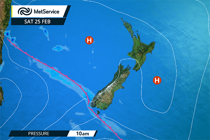
'However, there is a weak front moving onto the south of the South Island on Saturday bringing rain to Fiordland and a few showers to Southland, Canterbury and Otago.
'This should clear up again on Sunday, though there could be a few showers about the ranges of both Islands in the afternoon. Another high then moves in to bring more settled weather for the start of next week.”
The high pressure brings good news for those with tickets to the RNZAF Air Tattoo in Ohakea this weekend.
While there will be some cloud at times, the weather is expected to be mostly dry with high temperatures of 23C, but just a chance of a shower on Sunday.
Temperatures are expected to reach the mid to high twenties for many places around the country this weekend, particularly the North Island, with 28C for Masterton on Saturday and 26C in Coromandel on Sunday.
'Fortunately for us, after a busy Summer the recent settled weather is expected to continue into the start of Autumn.
'We will have more details on this in our March Outlook, out next week.” People can keep an eye out for the Monthly Outlook at http://info.metraweather.com/e/60812/MonthlyOutlook/cf6ssz/503473593.
Looking north to the tropics, we have just had our first tropical cyclone of the season in the Southwest Pacific.
After a record quiet start to the season, Tropical Cyclone Bart was named a Category 1 Tropical Cyclone at 1am on Wednesday, February 22.
It has since weakened and moved southeastwards, transitioning to an extra-tropical depression after only 30 hours as a tropical cyclone.
MetService is also keeping an eye on another tropical depression sitting near Fiji, and there is a chance it could develop into a tropical cyclone.
To keep up to date with what is happening in the tropics, see http://info.metraweather.com/e/60812/ings-tropical-cyclone-activity/cf6ss8/503473593

0 comments
Leave a Comment
You must be logged in to make a comment.