UPDATED 12.30PM: Power has been restored to homes in Welcome Bay, but other areas around the North Island are not so lucky.
While the lights have been switched back on in Tauranga, properties in Palmerston North, Hunterville, Thames, Te Aroha and Whangamata have had their power cut.
A vehicle hitting a pole in Palmerston North is the cause of the power outage there, while the rest of the outages are under investigation.
EARLIER:
Power is out to homes in Welcome Bay this morning as slow-moving heavy rain moves through the Bay of Plenty.
Around 941 properties have been left in the dark since about 6am.
Powerco repots a site investigation is underway into the cause of the outage, and hopes to have the supply back on around 10am.
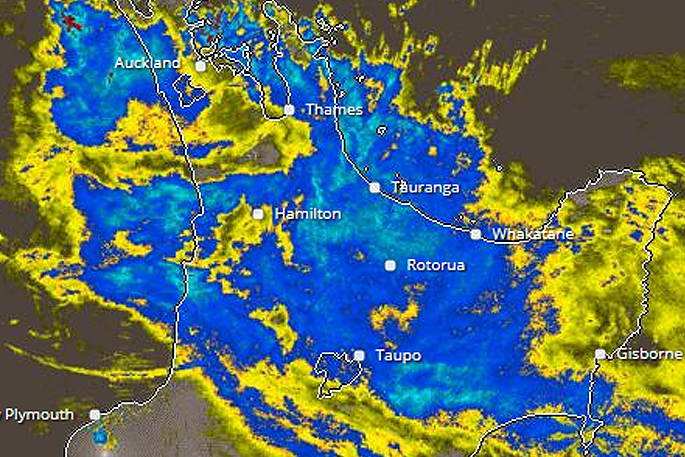
Meanwhile, a severe weather warning and thunderstorm watch is in place for the region.
Severe weather is affecting most of the North Island including, Auckland, Coromandel Peninsula, Waikato and the Bay of Plenty.
The MetService says an active frontal band is moving across the upper North Island this morning, bringing heavy rain to the region.
'Downpours and/or thunderstorms may produce localised rainfall rates of 25 to 40mm/hr and possibly more,” says a statement from the weather organisation.
'Rainfall of this intensity can cause flash flooding, especially about low-lying areas such as streams, rivers or narrow valleys, and may also lead to slips.
'Driving conditions will also be hazardous with surface flooding and poor visibility in heavy rain.”
Parts of State Highway 25 in the Coromandel are closed due to flooding. Other road closures are expected as the weather bomb crosses the country today.
Flooding is affecting State Highway 25 in the Coromandel. Sections CLOSED. Visit our website for details: https://t.co/diZbqAjYty ^TP pic.twitter.com/GkOhGqrLOI
— NZTA Waikato/BoP (@NZTAWaiBoP) March 7, 2017
According to Weatherwatch.co.nz, the rain is expected to ease later today.
Areas of rain in the north today will start to drift further back out to sea as high pressure over the South Island and lower North Island grows and alters the wind direction, says a statement on the weather organisation's website.
"Easterlies kick in and set in across the upper North Island with much of the nation dry today. Best chance for rain in the very north, where it will also be windiest.
"The Tasman Sea is split in half - with a large low to the north and large high to the south."
Auckland Northland Waikato BOP
Rain slowly easing to showers and increasing dry spells. Winds turn to the SE Highs: 22 to 25 Lows: 14 to 18
Western North Island (also Central Plateau)
Early rain clears with cloudy dry weather remaining. Cooler winds from the SE kicking. Highs: 18 to 22 Low: 12 to 14

0 comments
Leave a Comment
You must be logged in to make a comment.