Severe Tropical Cyclone Cook is now a Category 3 storm and may reach Cat 4 with sustained winds of 200km/h and gusts much higher before making landfall in New Caledonia tonight.
It's a bad forecast for the French island nation with both flooding rains, severe storm surge and damaging winds combining tonight as the cyclone makes brief landfall, says the latest update from WeatherWatch.co.nz.
'By Tuesday evening, Cook will be drifting south to south east away from New Caledonia and slowly towards New Zealand.
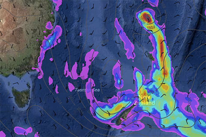
'However, Cyclone Cook is a very intense but small sized storm. The concern WeatherWatch.co.nz has at this stage is more to do with a larger sized low in the Tasman Sea joining forces with Cook to drag down more flooding tropical rains into the North Island of New Zealand.
'This set up could see rain returning to flooded parts of Bay of Plenty, for example, this Wednesday then intensifying as ex-cyclone Cook passes by over Thursday and Friday with torrential rain around eastern parts of the North Island - rain heavy enough to cause even further slips and flooding as possibly more than a months' worth of rain yet again falls in just a couple of days.”
As for the four day Easter Weekend - it doesn't look stormy so much as it looks unsettled for many regions. In other words a changeable forecast from day to day with a risk of some wet weather amongst the sunny and/or spells.
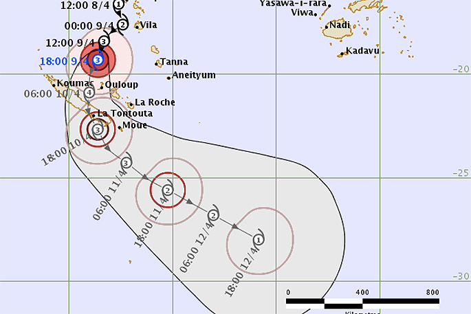 Latest track map as of 8am NZT / Fiji Met.

2 comments
As
Posted on 10-04-2017 18:07 | By Capt_Kaveman
of this post it is a Cat 2 6.06pm 10-4-17
kaveman
Posted on 10-04-2017 19:11 | By jjrk
are you looking at Metservice site? after cyclone cook was formed and named i looked on metservice and it was still a low with a high chance of becoming a cyclone in the tropical cyclone advisory tab, even though the surface pressure chart had a "T" in the middle of that low with "cook" above it . so i assume coz its "way up there" at the moment there a bit slow to update. i think fiji metservice has more juristriction up those ways
Leave a Comment
You must be logged in to make a comment.