Heavy rain is now falling over parts of the country and is expected to continue into Thursday.
Further rainfall accumulations could exceed 160mm over Bay of Plenty and Taupo during this time, with lesser amounts in other areas.
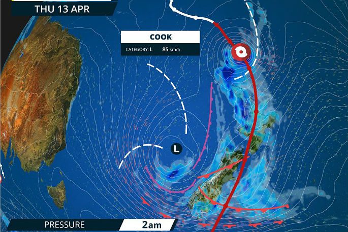
The MetService says a low lies slow moving west of the South Island directing a moist and unsettled northeasterly airstream over New Zealand.
"Cyclone Cook is expected to make landfall over the Coromandel Peninsula or western Bay of Plenty Thursday afternoon and move southwards reaching Wellington in the early hours of Friday morning.
"On this track, damaging severe gales with gusts of 150 km/h or more are possible, affecting regions from Auckland to Coromandel Peninsula and Bay of Plenty, down to Wellington.
"Eastern coastal areas of Auckland, Coromandel Peninsula and Bay of Plenty may see large waves of 5 metres or more, storm surges near the centre of Cyclone Cook, coastal inundation and erosion."
The precise track of the Cyclone centre may change as the system approaches.
People should be aware that this is a very significant event and is likely to produce widespread flooding, slips and wind damage, including to powerlines and may even lift roofs and bring down large trees.
Driving conditions are likely to be hazardous, so people will need to take extra care on the roads, and even consider altering their Easter travel plans.
HEAVY RAIN WARNING
AREA/S AFFECTED
Northland
FORECAST
Periods of heavy rain are expected from Wednesday evening until Thursday midday. In the 16 hours from 8pm today to midday Thursday, a further 80 to 100mm is forecast to accumulate in addition to what has already fallen, especially in the east. Maximum rainfall rates 30 to 40mm per hour and thunderstorms possible.
AREA/S AFFECTED
Auckland, including Great Barrier Island
FORECAST
Periods of heavy rain are expected from Wednesday evening until Thursday evening. In the 20 hours from 8pm Wednesday to 4pm Thursday, 90 to 120mm is forecast to accumulate, but Great Barrier Island could get 150 to 180mm, in addition to what has already fallen. Maximum rainfall rates 30 to 40mm per hour with thunderstorms possible.
AREA/S AFFECTED
Coromandel Peninsula, Bay of Plenty Rotorua and Taupo
FORECAST
Periods of heavy rain are expected from Wednesday evening until Thursday evening. In the 24 hours from 8pm Wednesday to 8pm Thursday, 120 to 160mm is forecast to accumulate, in addition to what has already fallen. Maximum rainfall rates 30 to 40mm with thunderstorms possible.
AREA/S AFFECTED
Waikato and Waitomo
FORECAST
Periods of heavy rain are expected from this evening until Thursday evening. In the 24 hours from 8pm Wednesday until 8pm Thursday, 100 to 120mm of rain may accumulate. Maximum rainfall rates 25 to 35mm per hour.
AREA/S AFFECTED
Mount Taranaki and Tongariro National Park
FORECAST
Periods of heavy rain are expected from this evening until Thursday evening. In the 24 hours from 8pm Wednesday evening until 8pm Thursday, 100 to 120mm of rain may accumulate. Maximum rainfall rates 25 to 35mm per hour.
AREA/S AFFECTED
North Otago, Dunedin and Clutha
FORECAST
Rain is expected to ease Thursday morning. In the 16 hours from 8pm today to midday Thursday, a further 50 to 60mm is forecast to accumulate on top of what has already fallen. Maximum rainfall rates 15mm per hour. Note, a further period of heavy rain is likely Friday afternoon.
FREEZING LEVEL: Above 3000 metres.
STRONG WIND WARNING
AREA/S AFFECTED
Auckland including Great Barrier Island, Waikato and Waitomo
FORECAST
From Thursday afternoon until Thursday evening, severe gales with gusts of 120 km/h or more are possible.
AREA/S AFFECTED
Coromandel Peninsula and Bay of Plenty
FORECAST
From Thursday afternoon until Thursday evening, severe gales with gusts of 150 km/h or more are possible. Also, coastal areas in the east can expect large waves of 5 metres or more during this time, with storm surges near the centre of Cyclone Cook, and possible inundation and coastal erosion.
AREA/S AFFECTED
Taumarunui, Taupo, Taihape,Taranaki, Wanganui, Manawatu, Horowhenua Kapiti Coast and Wellington
FORECAST
From Thursday evening until early Friday morning, severe gales with gusts of 140 km/h or more are possible.
AREA/S AFFECTED
Gisborne and Hawkes Bay
FORECAST
From Thursday afternoon until Thursday night severe gales are possible with gusts of 140km/h or more.
AREA/S AFFECTED
Wairarapa
FORECAST
From Thursday evening until early Friday morning severe gales are possible with gusts of 140km/h or more.

0 comments
Leave a Comment
You must be logged in to make a comment.