Heavy rain and possible thundery falls are being forecast for the Bay of Plenty and Gisborne today.
The MetService's weather warning, which was issued on Wednesday, remains in place today.
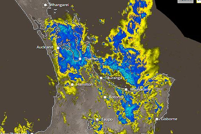
'The heaviest falls are expected over Bay of Plenty and northern Gisborne where a further 80 to 120mm may accumulate till midnight Friday.”
Forecasters have been tracking the current weather system since Monday.
WeatherWatch.co.nz described the current incoming sub-tropical low as "frustrating to forecast" due to it's large size, slow tracking and the fact the large centre means there will also be large areas of calm and dry.
'To make matters more frustrating the large mountains and ranges in New Zealand can block the rain, stop the rain or make it heavier and prolonged for a few - and just a tiny shift in wind flow can have significant consequences,” says WeatherWatch.co.nz
'As we reported late Thursday afternoon, the low is gently nudging this rain away from Northland and Auckland for the most part while at the same time the nor'east flow is trying to pull it back to land.
'So this rain band is being pushed and pulled a bit and breaking apart.”
Don't get complacent! This is sub-tropical after all...
'At the risk of now contradicting ourselves, a sub-tropical low can be unstable and that means rain clouds can bubble up quickly and be quite intense - especially with low pressure moving in,” says WeatherWatch.co.nz.
'On Friday, the low deepens further so we may see more quite isolated pockets of flooding as the rain bands track southwards down the eastern coastline of New Zealand (for the most part eastern areas are more vulnerable to heavier rain).
'Once the low tracks over the North Island, a wet and windy south west flow will blow over the upper North Island later on Friday/overnight and into Saturday.”
We're not done with the raincoat yet! Another day or so from the swirling Tasman low.Rain/showers/thunder/cold/yuck! https://t.co/3zsDJI5koT pic.twitter.com/MoeS1XDY7L
— Daniel Corbett (@danielcorbetttv) June 22, 2017

0 comments
Leave a Comment
You must be logged in to make a comment.