While the skies may look reasonably clear around the country today, tomorrow is going to be a different story.
Weather forecaster are predicting deluges of rain for most areas, with some regions expected to get around two months' worth of rain in one day.
The MetService is calling the approaching weather a "significant winter storm".
A severe weather watch is in place for the Bay of Plenty with heavy rain expected from Thursday afternoon through to Thursday night.
According to WeatherWatch.co.nz, a northerly airflow gradually builds over New Zealand today while a large low forms in the Tasman Sea, says WeatherWatch.co.nz
'A front moves in from the west on Thursday with a strong north to northeasterly airflow preceding it.
'A deep low moves onto the South Island on Friday bringing very strong winds around it and some heavy rain, especially about the eastern South Island.”
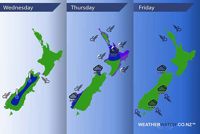
Wednesday
Blue - A frosty start about a thinner slice of the inner South Island, no major frosts.
Purple - As a northerly quarter airflow increases over New Zealand during the day northwesterly winds becoming gusty through Cook Strait and northeasterlies strong about coastal Fiordland from afternoon.
Thursday
Blue - A deep low forms moving into position west of the South Island on Thursday. Hooked into this low is a front which moves in from the west delivering heavy rain about the upper North Island and Nelson / Tasman in the evening then easing overnight. Rain about Fiordland may be heavy then easing from afternoon.
Purple - North to northeasterly winds preceding this front are quite strong with gales likely about coastal areas especially about northeastern parts of the North Island.
Friday
This low deepens further and sits over the upper South Island on Friday, winds around the low are gusty and strong, more so about the eastern South Island south of Banks Peninsula where severe gales may develop about the coast. Expect some heavy rain also about the eastern South Island Banks Peninsula southwards.
Snow keeps above 800m for the South Island, lowering to 500m in the evening about Southland. Snow lowering to 500m overnight about Mid and South Canterbury also.
The difference between the normal low last Thursday (left) and the deep low that is crossing #NewZealand this Thursday (right): pic.twitter.com/q2lrLJ2PQT
— Philip Duncan (@PhilipDuncan) July 18, 2017

0 comments
Leave a Comment
You must be logged in to make a comment.