Today Cyclone Cook is expected move onto northern New Zealand during the day then move southwards down the country in the evening and overnight.
Very strong winds and heavy rain will be associated with this low and the areas most affected will be determined by where this deep low moves.
Ex-Cyclone Cook moves southwards over the South Island on Friday while northwesterlies lie over the North Island. West to northwesterly winds for much of Saturday.
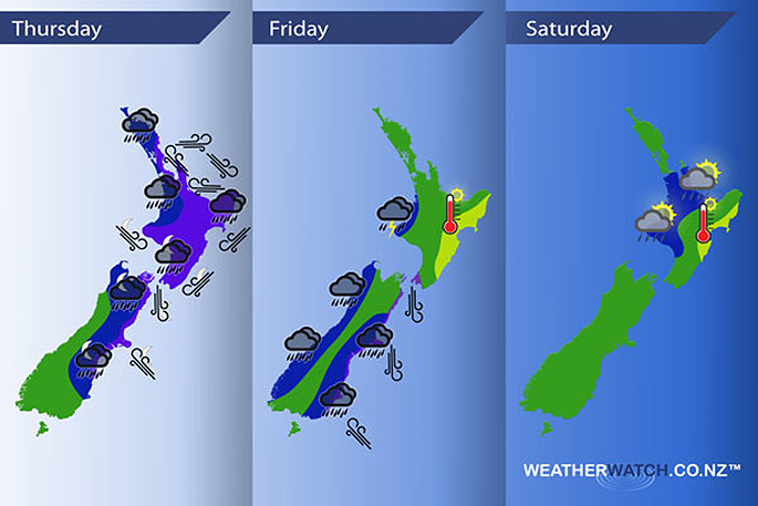
Thursday
Cyclone Cook moves onto the north of the country this afternoon then pushes southwards in the evening and overnight.
With this strong low brings the potential for heavy rain (torrential falls for some) and very strong winds.
Any subtle shift in the centre of this low could result in a different outcome for various regions regarding rain and wind.
However, current indications are that most parts of the North Island could experience some heavy rain at some point during the day, then the top of the South Island and eastern South Island overnight.
The above weather model from NIWA shows Cyclone Cook making landfall just south of Whangamata around 6pm.
The main focus seems to be Auckland, Waikato, Bay Of Plenty and perhaps parts of the Central North Island and northern Taranaki.
These areas of very heavy rain will build in the afternoon then ease from evening. A risk of torrential falls and flooding is possible.
Trying to pin point the situation a bit more, the Coromandel, Great Barrier Island, western Bay Of Plenty and the Waikato may bear the brunt of this low.
As noted above very strong winds are likely with this low.
Winds will strengthen from the east in the afternoon about the upper North Island with severe to storm force gales possible about eastern areas then winds change around to the northwest late afternoon or evening once the low moves through.
Northwest winds could be equally as strong for a time when the change kicks in then easing away fairly quickly. Very strong north to northeasterly winds push down the eastern side of the country during the evening and overnight, ahead of this strong southeasterly winds may build about coastal Canterbury overnight.
Winds through Cook Strait could be very strong from the north for a time overnight.
Gusty southeasterly winds about coastal parts of the lower South Island ease away this morning.
Friday
Blue - Heavy rain pushes southwards during the day along the east coast of the South Island, easing about Canterbury in the morning then about Otago and Southland late afternoon / evening. Some heavy rain at times about North Westland from morning then South Westland from afternoon. All heavy rain eases overnight.
In the evening and overnight heavy showers and thunderstorms may affect Taranaki.
Purple - Strong winds will mainly be limited to coastal fringes of the eastern South Island and may only be very strong for a relatively short amount of time as a deep low centre passes southwards during the day. Winds generally strong to gale from the south or southeast then changing to the north once the low moves by. Northerlies through Cook Strait will likely be gale force in the morning then easing by midday.
Yellow - High's reaching into the mid 20's for the east coast of the North Island in the afternoon.
Saturday
Blue - Showers in the afternoon and early evening may bring an isolated heavy fall or two, low risk of some thunder even then easing later on.
Yellow - High's reaching into the mid 20's for the east of the North Island once again.
- Aaron Wilkinson, WeatherWatch.co.nz

1 comment
Presenting credentials
Posted on 13-04-2017 08:49 | By penguin
The cyclone is probably here in answer to a job offer at a Tauranga restaurant for a ''Cook.''
Leave a Comment
You must be logged in to make a comment.