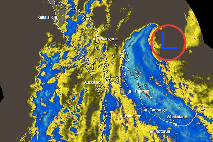
The storm that was once Tropical Cyclone Cook is now clearly showing up on New Zealand rain radar directly east of Whangarei and heading south into Bay of Plenty.
The outer bands of the centre (where the heaviest rain and strongest winds are) is now pushing into eastern and northern Coromandel Peninsula and into Bay of Plenty.
Slips and flooding should be expected - this may be a significant event in this area, says WeatherWatch.co.nz.
'It appears the centre of the low will be making landfall in Bay of Plenty sometime between 3pm and 6pm we believe.
'The reason why we focus on the centre is because the most severe weather extends out from it by about 150 to 200kms - beyond that things aren't generally so concerning.
'Also, the centre is where the biggest storm surge is (the centre of the spinning low is so powerful it sort of sucks up the sea height below it, creating a tide that can be half a metre to a metre above normal, adding to coastal flooding concerns).
'Our feeling is that Auckland City and Northland generally remain well to the west of the severe weather - but severe weather may impact these regions this afternoon for a time, but mostly out over the Gulf and Great Barrier Island in our view.”
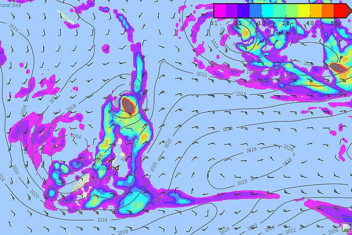
HEAVIEST RAIN See our Rain Maps here to click through the next few days and get a better idea as to how this is looking.
THURSDAY Rain, especially heavy in BAY OF PLENTY & COROMANDEL PENINSULA (regions nearby, like western Northland, the Far North, eastern Bay of Plenty, Waikato and Auckland may also all be impacted should Cook jog slightly further west or east during Thursday morning).
Rain with heavy falls spreads into many other North Island regions.
The heaviest rain may only last 2 to 5 hours as this low comes through.
South Islanders have rain also, becoming heavy in the north in the afternoon then tracking southwards during the evening, especially in the north and east.
Rain will be widespread across much of New Zealand by Thursday PM.
FAST MOVING RAIN MOVES SOUTH ON FRIDAY: Cook will be fast moving, by midnight Thursday it may already be at Cook Strait (named after the Captain not the storm!). It will be the first time in history a storm named Cook not only hit Cook Strait but crossed directly over it.
By Friday morning Cook the storm will be centred near Christchurch if current modelling stays true. Downpours may be intense in SOUTH CANTERBURY and COASTAL OTAGO for a time on Friday morning.
There is some concern in DUNEDIN and COASTAL OTAGO from flooding - the downside (at this stage) with Cyclone Cook is that the low itself will likely slow down around the lower South Island and this could feed persistant rain into the area. We'll update in more detail tomorrow afternoon as the low moves in closer. The further south we forecast and the further ahead we forecast the less accuracy there is.
Rain may ease in Northland and Auckland by evening.
STRONG WINDS
THURSDAY PM With recent major floods in the upper North Island the main concern from authorities is further flooding - but winds are also an issue with Cook, especially now that the storm is going to track directly into the North Island and across or near some of our most populated centres and regions.
The good news is that the worst of the winds will be mostly out at sea and to the east of the country - and Cook is moving through fast.
The bad news is that damaging winds may impact some areas around the centre of this low. Places like GREAT BARRIER ISLAND, COROMANDEL PENINSULA, EASTERN WAIKATO, EASTERN HAURAKI PLAINS, BAY OF PLENTY, EAST CAPE - then later on and into GISBORNE, TAUPO HAWKES BAY for Thursday PM. Winds pick up in WAIRARAPA and WELLINGTON later/overnight and sometimes these winds can be even stronger on the other side of the ranges in eastern Manawatu, Horowhenua, Kapiti.
But this is moving through fast so we hope any possible damage will be limited - in fact peak gales may only last an hour or two for some areas. FRIDAY On Friday the area of damaging winds pretty much hugs the coastline of the South Island and lower North Island first thing, affecting WELLINGTON/COOK STRAIT, CANTERBURY then COASTAL OTAGO during the day. Coastal areas are most at risk in all the above regions, or those in well-known wind tunnels.
The good news is the damaging winds will be a short burst for most places. In winter we get squalls that can bring damaging winds for 10 minutes or so. Cook may be a longer, much bigger, version of one of those squalls, lasting for 2 or 3 hours with peak winds and rains as it churns southwards. Some places may just have a burst of wind and rain similar to the usual weather we get in New Zealand, but there is also a high chance winds will be briefly damaging in some places. Keep up to date with MetService wind warnings for more regional information.
Winds may also weaken a little as the low crosses the North Island and heads further south.
- WeatherWatch.co.nz

0 comments
Leave a Comment
You must be logged in to make a comment.