Heavy rain and gale northeasterlies for northern and central New Zealand Thursday and Friday.
The MetService has issued severe weather warning for heavy rain.
'A rapidly deepening low is forecast to approach New Zealand from the northwest today, then to lie the west of the North Island on Thursday while continuing to move southeastwards,” says a statement from the weather organisation.
'During Thursday, the low spreads a moist and strong northeast flow over central and southern New Zealand, delivering heavy rain and strong northeasterly winds to these areas.”
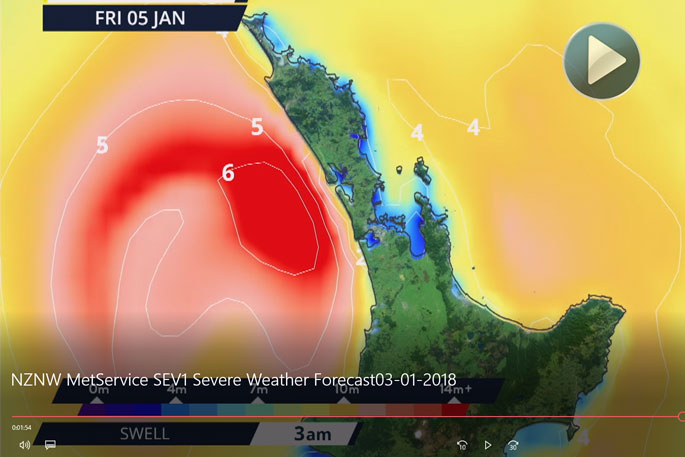
The heaviest rain is expected in Northland, Auckland, Coromandel Peninsula, Bay of Plenty, Mount Taranaki, Marlborough, and Nelson, and warnings for heavy rain are now in force for these areas.
'The strongest winds are expected across the upper North Island, from Taranaki to Bay of Plenty northwards, and a warning for severe gale northeasterlies is now in force for these areas. Note, the combination of strong winds and high tides could cause coastal inundation about eastern areas from Northland to Bay of Plenty including the Firth of Thames.
'The low should cross central New Zealand on Friday bringing a period of gale westerlies to the North Island, and gale southeasterlies across the upper South Island. The low should then move away to the southeast of the country on Saturday.”
People should keep up to date with the latest forecasts in case other areas are added to the WARNING.
Persistent showers forecast throughout today in the Bay of Plenty. Check out the forecast at https://t.co/q36ltTKxon. Judging by the @snapithd Tauranga webcam its the perfect morning for a lie in! ^JM pic.twitter.com/2z8wi1Ujl6
— MetService (@MetService) January 2, 2018
==================
HEAVY RAIN WARNING
==================
Heavy rain may cause streams and rivers to rise rapidly. Surface flooding and slips are also possible and driving conditions may be hazardous.
Area: Northland
Valid: 12 hours from 9am to 9pm Thursday
Forecast: Rain is expected to become heavy for a time from Thursday morning until Thursday evening. Expect 80-120mm of rain to accumulate about the northern and eastern hills during this time, while 50-80mm of rain may accumulate elsewhere. Peak intensities of 15 to 25mm/hr possible, especially in the afternoon.
Area: Auckland including Great Barrier Island
Valid: 12 hours from 12pm Thursday to 12am Friday
Forecast: Rain is expected to become heavy for a time from midday to midnight Thursday. Expect 70-90mm of rain to accumulate during this time, especially about the Hibiscus Coast, and the Waitakere and Hunua Ranges. Peak intensities of 15 to 25mm/hr possible, especially in the evening.
Area: Coromandel Peninsula
Valid: 13 hours from 1pm Thursday to 2am Friday
Forecast: Rain is expected to become heavy for a time from early Thursday afternoon to overnight Thursday. Expect 100-150mm of rain to accumulate during this time, especially about the ranges. Peak intensities of 20 to 30mm/hr, especially from evening.
Area: Bay Of Plenty including Rotorua
Valid: 15 hours from 3pm Thursday to 6am Friday
Forecast: Rain is expected to become heavy for a time from Thursday afternoon to around dawn Friday. Expect 120-160mm of rain to accumulate about the ranges, especially the Kaimai and Mamaku ranges, while 70-100mm of rain may accumulate elsewhere. Peak intensities of 20 to 30mm/hr possible.
Area: Mount Taranaki
Valid: 9 hours from 6pm Thursday to 3am Friday
Forecast: Rain is expected to become heavy for a time from Thursday evening to early Friday morning. Expect 100-150mm of rain to accumulate during this time.Peak intensities of 20 to 30mm/hr.
Area: Nelson
Valid: 9 hours from 12am to 9am Friday
Forecast: Rain is expected to become heavy at times from around midnight Thursday until mid-morning Friday. Expect 120-160mm of rain to accumulate about the ranges west of Motueka, while 50-80mm of rain may accumulate elsewhere. Peak intensities of 25-40mm/hr, especially about the western ranges.
Area: Marlborough including the Kaikoura Coast
Valid: 9 hours from 12am to 9am Friday
Forecast: Rain is expected to become heavy at times from around midnight Thursday until mid-morning Friday. Expect 100-150mm of rain to accumulate about the Kaikoura Ranges, while 70-100mm may accumulate elsewhere, especially the Richmond Range. Peak intensities of 20 to 30mm/hr possible.
===================
STRONG WIND WARNING
===================
Strong wind gusts could damage trees, powerlines and unsecured structures.Driving may be hazardous, especially for high-sided vehicles and motorcycles.
Area: Northland
Valid: 5 hours from 4pm to 9pm Thursday
Forecast: During Thursday evening, northeasterlies are expected to become severe gusting 120 km/h in exposed places.
The combination of strong winds and high tides may also cause coastal inundation in eastern areas.
Area: Auckland including Great Barrier Island
Valid: 6 hours from 6pm Thursday to 12am Friday
Forecast: During Thursday evening, northeasterlies are expected to become severe gusting 120 km/h in exposed places.
The combination of strong winds and high tides may also cause coastal inundation in eastern areas including the Firth of Thames.
Area: Coromandel Peninsula, Waikato, Waitomo, Taumarunui, Bay Of Plenty, Rotorua, Taupo and Taranaki
Valid: 9 hours from 9pm Thursday to 6am Friday
Forecast: From Thursday evening until around dawn Friday, northeasterlies are expected to become severe gusting 120 km/h in exposed places.
The combination of strong winds and high tides may also cause coastal inundation in Coromandel and Bay of Plenty including the Firth of Thames.

0 comments
Leave a Comment
You must be logged in to make a comment.