Another period of heavy rain and strong winds is forecast for parts of New Zealand today and into tomorrow.
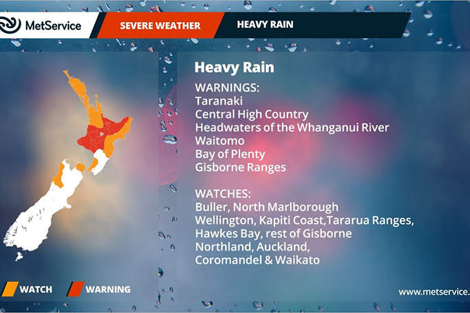
MetService has issued a series of severe weather warnings and watches covering much of the Central and Northern New Zealand.
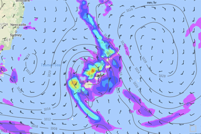
This wet weather is the result of the combination of a front heading slowly eastwards across the country and the remnants of what was Tropical Cyclone Donna sinking southwards.
As the front moved over the Nelson region during the early hours of Thursday morning, rainfall totals exceeded 50mm at Nelson airport with nearby observation stations reporting similar amounts in just under an hour.
As the front continues to track eastwards, heavy rain with some local downpours is forecast to move further across the North Island.
Severe Weather Warnings are already in place for Taranaki, the Central High Country as well as Bay of Plenty and the ranges of Gisborne while a Severe Weather Watch covers the rest of the North Island.
'The tracks of Ex-Tropical Cyclones are sometimes hard to forecast, as we have seen in other recent events,” says Metservice Communications Meteorologist, Lisa Murray.
'Approaching from the northwest, the remnants of Donna form a broad area of low pressure that slides across the north of the county overnight and into Friday.
'Although there is still much uncertainty as to the speed and positioning of the Ex-Tropical Cyclone it is looking like a wet night for many on the North Island,” says Lisa.
'The wettest areas are expected to be Bay of Plenty, Central Plateau and the Gisborne Ranges although other areas can expect to also see downpours which could cause some surface flooding and landslips.”
Accompanying the wet weather will be some stronger winds.
A severe weather watch is in place for strong to gale force northeasterlies over central and upper parts of the North Island.
As the low pulls away to the east the winds will swing round to the south, still strong to gale in some places.
'Aucklanders should prepare for some localised heavy falls and strong wind,” says Lisa.
'Auckland is currently under a severe weather watch for heavy rain and strong winds, but this could be upgraded to a Warning if the system tracks closer to the region.”
Most western areas of the South Island have sunshine on Friday while a weak front moves up the eastern side brings a period of showers as it passes.
By Friday evening the worst of the weather is forecast to pull away into the Pacific leaving a drier and brighter weekend, just in time for Mother's Day.
However, with the winds swinging around to the south it's going to feel much cooler.
EDGECUMBE
Edgecumbe residents and farmers are advised that measures have been taken to make their district as safe as possible from the rainfall forecast for today and tonight.
The BOPRC says the amount of rain forecast will not threaten the stopbank and that their river flap gates are repaired and operational.
The Edgecumbe treatment ponds have been reduced to a low level and are expected to have ‘freeboard' to accommodate more rain and wastewater flow rates.
The main area of concern is that the cleaning up process will be slowed down with the additional rain as low lying areas are still saturated.
Additional staff will be on standby for the heaviest rainfall periods and a vacuum tanker will be on standby in Edgecumbe just in case there are any overflows from the stormwater system.
If an alert is received (via telemetry) the Otakiri valve will be activated. And as an extra precaution it will be monitored by a WDC staff member.
Residents of Edgecumbe and other towns in the district, are asked to check your house gulley traps are clear before the rainfall arrives.
New Zealand's stuck in a pattern - another rain maker likely next week
The third ex-cyclone in two months is about to cross New Zealand dumping more torrential rain and bringing more than a months' worth of rain to some areas over the next two days.
Flooding is possible once again with the North Island already drenched and wetter than average in every region, says WeatherWatch.co.nz
So what happens after Donna?
It appears New Zealand is stuck in a rut, weather-wise that is.
After the remnants of Donna pass by on Friday and Saturday yet another large high will drift over New Zealand from the Tasman Sea.
 A weather map for next Wednesday. Iamge: Weathermap
'This is another powerful anti-cyclone and should bring more settled weather for three or four days to many parts of the country,” says the weather organisation.
'As it moves away next Tuesday, it looks quite possible that yet another warmer-than-average northerly flow will spread down over the country from the sub-tropics. This is then followed by another low that at this early stage looks likely to cross the country from the Tasman Sea.
'This low is followed by another large high.
'When you zoom out and look due west around the globe you notice a pattern - high, low, high, low, high tracking eastwards towards the New Zealand area.”

0 comments
Leave a Comment
You must be logged in to make a comment.