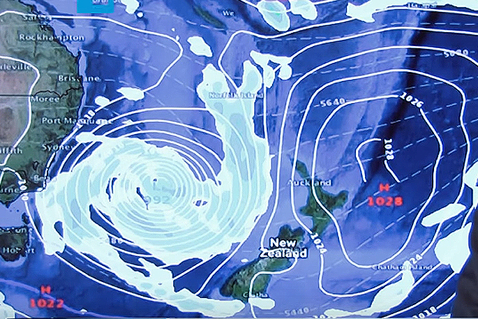
A big low growing to engulf much of the Tasman Sea is expected to tap into sub-tropical air just north of New Zealand.
WeatherWatch.co.nz says this will help to fuel more heavy rain on Wednesday as the system slowly crosses the country.
'By Thursday a windy south to south west flow will spread northwards across most of the country and by Friday all of New Zealand will be cooler - with the worst of the polar blast mainly out to the east of the South Island,” says the weather organisation.
A big high is coming afterwards - the weekend coming up should see conditions ease and calm down again.
'There's currently quite a strong pattern of large highs and deep lows tracking in from the west - but despite these large highs the rain events have made May wetter than average so far in most parts of the country.”

1 comment
Of the past
Posted on 16-05-2017 09:10 | By penguin
For those who were born many years ago, the weather pattern described by WeatherWatch is what used to be ''normal.'' There was roughly a 10 day cycle . Three days of low pressure, stormy and unsettled weather and approximately seven days of high pressure, settled conditions. This cycle was acknowledged by the then weather office. Over the years this pattern has changed considerably. Many maintain that Labour weekend usually marked the beginning of summer as the sun nearly always shone from a clear blue sky!
Leave a Comment
You must be logged in to make a comment.