Updated tsunami evacuation maps for Tauranga are now available online and will be delivered to all households within the Mount and Papamoa evacuation.
Over the past five years, Tauranga City Council has created a network of tsunami evacuation routes and safe locations in coastal areas.
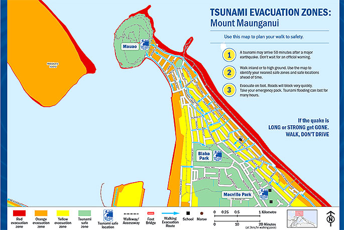
Later this month, households in the Mount Maunganui, Arataki, Papamoa and Wairākei areas will receive a copy of four separate brochures that show the tsunami evacuation zones.
'The maps are a prompt for residents to make evacuation plans, having a plan in place will save time and potentially lives during an event,” says Tauranga City Council Manager emergency management Paul Baunton.
'Use the maps to work out where you need to go to escape a tsunami, and practice your route.”
The maps are updated annually to include new development areas and changes to road, cycleway and walkway networks.
"If you feel an earthquake that is long and strong, then get gone. That is the first and most reliable sign that a tsunami could be on the way.
'You should evacuate as soon as you can after that earthquake. We recommend you walk to avoid crippling traffic jams.
'The maps show there are safe locations and areas within achievable walking distances from most places along the coast,” says Paul.

1 comment
genius
Posted on 19-12-2017 08:37 | By Captain Sensible
The genius who came up with the Tsunami Escape Plan I recently saw....head AWAY from ( not towards) the sea!
Leave a Comment
You must be logged in to make a comment.