As a ridge of high pressure drifts eastwards, a deep trough will bring a period of rain and gales to many places this week, followed by a brief cold outbreak with snow to unseasonably low levels.
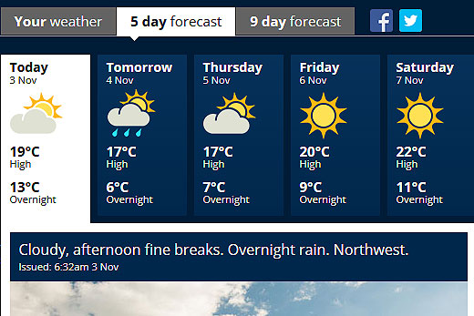
However, in the Bay of Plenty, today is looking cloudy with fine breaks throughout the afternoon before overnight wind and rain tomorrow.
Rain is forecast for the Bay of Plenty tomorrow. Image: MetService.
North-westerlies are set to spread up southern and central New Zealand ahead of an approaching front today, also bringing cloudy periods to western places.
Folk in the east can expect their run of fine weather to continue, with daytime temperatures reaching the mid-twenties in some places.
Cloudy periods are forecast for Thursday, with fine weather expected to shine on Friday, according to the MetService's five-day forecast.
'On Tuesday there will be a period of heavy rain on the West Coast,” says meteorologist Peter Little, 'and in the east, following a period of blustery north-westerlies, there will also likely be some decent rain which will be useful after a dry October.”
Rain spreads over much of the North Island tonight, but the heaviest rain is expected on Wednesday as the low progresses northwards.
A strong, cold southerly flow spreads over New Zealand following this weather system, with snow forecast as low as 300 metres over southern and eastern parts of the South Island today.
'There is the potential for significant accumulations of snow, especially about the inland Canterbury Plains, but the snow is not expected to affect those living in coastal cities or towns,” adds Peter.
A watch for heavy snow is in force for Canterbury, Otago and Southland, in addition to the heavy rain and severe north-west gales possible in these areas.
Road snowfall warnings have also been issued for some of the South Island passes, as well as a heavy rain warning for Fiordland and Westland.
A new ridge of high pressure brings more settled weather over the South Island during Wednesday and Thursday, with frosty starts for most places.
Meanwhile the low lingers east off the North Island, directing rain into eastern areas along with large waves.
The cold southerly will likely bring snow to the Desert Road and possibly some other high country roads for a time.
Skies should be mostly clear over the South Island and in the north and west of the North Island by Thursday evening for those wanting to celebrate Guy Fawkes.
The ridge drifts over central New Zealand on Friday, clearing the rain from all but Gisborne, and once again north-westerlies build further south as another front approaches from the Tasman Sea ahead of the weekend.


0 comments
Leave a Comment
You must be logged in to make a comment.