Western Bay of Plenty District Council have issued a call out for historic photos of the old Katikati railway line to help recreate how the area once looked as part of a new cycleway project for the township.
Council plan to construct a cycleway/walkway network between Katikati's Haiku Park and Hunter Reserve, with work expected to begin next year.
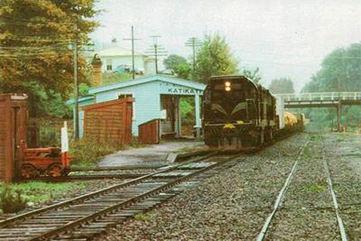
A photo of one of the last trains to pull in to Katikati Railway Station, taken in 1978. Photo: Len Baker/Tauranga Memories.
One of the proposed new routes is along the old railway line, south of the former Katikati Railway Station, and officials want to recreate how the area once looked as part of the project.
'We have searched the Katikati Library archives,” says council staff member Scott Parker, 'but there's not much photographic evidence there.
'So we figured there may be some old treasured photos of Katikati yesteryear stored away in residents' drawers or albums.
'These photos will help us piece together history and will also be very useful for interpretive signage along the walkway explaining the area's history.”
Scott says the photos he is particularly keen to find are those that pre-date the closure of the railway line in 1978.
'We would like to see the railway section immediately south of the old Railway Station, where it crossed the Uretara Stream and another 500m or so to the south.”
The railway was opened in 1928 and served the Katikati district for 50 years until it closed when the Kaimai Tunnel opened in 1978.
The tunnel bypassed the old East Coast Main Trunk Line through Karangahake Gorge.
The Katikati Railway Station was burnt down by an arsonist in 1988 – ending an important era of the township's history.
Scott says this new project is part of a longer term plan to extend the existing 3.6km of Uretara Stream walkways between the end of Park Rd and Haiku Park, all the way to Hunter Reserve on Wharawhara Road.
'The first stage will involve building a new bridge spanning the Uretara, upstream of the existing Haiku pedestrian bridge on a similar alignment to that of the old railway line,” he says.
'We hope to get this started before June 2016.”
Once the bridge is in place, new cycleway/walkway linkages on the east side of the Uretara will connect to Henry Rd/State Highway 2, Rawaka Drive and Hunter Reserve.
The trail to Henry Road will follow the old railway line embankment/cutting – a distance of about 400m.
The other longer 1.5km trail will generally follow the Uretara upstream, ending at Hunter Reserve.
*Any relevant photos can be given to the Katikati Information Centre.

0 comments
Leave a Comment
You must be logged in to make a comment.