Tauranga City Council has updated the tsunami evacuation maps for Mount Maunganui, Bayfair, Papamoa and Papamoa East.
The maps were reviewed and updated to reflect new road developments and refinements to tsunami modelling and infrastructure, and are available for download on council's website.
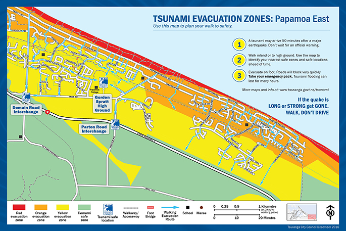
Last updated in May 2016, the evacuation maps are based on a 14m tsunami, which is considered the maximum credible tsunami for the Bay of Plenty region.
Walking evacuation routes on the maps have been updated to show the shortest distances, while the Papamoa and Papamoa East maps now make it clearer what parts of the raised berm alongside State Highway 2 and the Tauranga Eastern Link are in the tsunami safe zone.
Emergency Management manager Paul Baunton says every iteration of the evacuation zone maps goes through a thorough review process.
'A team of people across several organisations are closely involved with the Tauranga City tsunami maps. All changes are reviewed by the Bay of Plenty Civil Defence group and Tonkin and Taylor.
'We make small but important improvements each time so that the maps will be as helpful and accurate as possible for our community.”
Public feedback has also helped council improve both the maps and evacuation routes on the ground.
'Residents who have practiced their evacuation routes often give us helpful feedback and they alert us to things that need to be changed.”
Council has recently constructed an additional evacuation path connecting Shaun Close with Harding Drive. Evacuation signs for this new route will be installed in January.
Paul is encouraging everyone to take some time to study the maps and to practice their evacuation route so they know exactly where to go after an earthquake.
'If the earthquake lasts longer than a minute, or if it is strong enough to knock you over, you need to get going immediately.”
Other natural warning signs include the ocean making strange roaring noises or a sudden change in sea level.
Printed versions of the new maps will be available in public libraries later next week. The council is also planning to distribute a map to every household along the coast in January.
For more information and to download the maps visit the Tauranga City Council website at: www.tauranga.govt.nz/tsunami

1 comment
If we try hard enough.............
Posted on 10-12-2016 22:34 | By groutby
then everyone will become totally paranoid about a "tsunami" incident...only a few years ago we hadn't even heard of them!!...TCC...tell us the guts and move on....PLEASE!
Leave a Comment
You must be logged in to make a comment.