The Bay of Plenty Regional Council has approved the purchase of a neighbouring property that adds 25 hectares to the Papamoa Hills Cultural Heritage Regional Park.
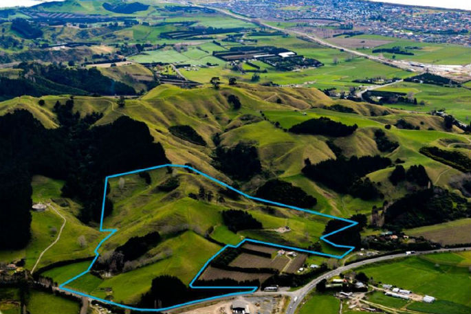
The 25ha property located at 8b Poplar Lane is immediately south of the regional park and encompasses a culturally significant pa complex/ridgeline, plus road frontage and flat land providing possible future access to the Park via Poplar Lane.
Run as a sheep and beef grazing block for the past several decades, the property was put up for sale by tender late in 2016. Regional councillors voted unanimously to put in a tender at an extraordinary meeting on December 7, which was subsequently accepted by the vendors.
The purchase takes the Papamoa Hills Regional Park to 160ha, adding two further pa sites, improving archaeological protection and providing opportunities for improved recreational access.
Included in Pim De Monchy's report to the council's Komiti Maori is an assessment from Heritage New Zealand stating the property has four recorded archaeological sites identified within the 25ha, two pa – both of which are contiguous with pa in the regional park, a terraced hill site, and an adze ‘findspot'.
It is highly likely that the property contains additional unrecorded sites that have both visible and buried archaeological features.
The ‘Papamoa Pa Complex' was nominated in 2004 for assessment for inclusion on the New Zealand World Heritage Tentative List.
This nomination encompassed an area bounded by State Highway 2 to the north and east, Welcome Bay Road and Reid Road to the west, and Poplar Lane to the south. The Papamoa Hills Regional Park, and the property at 8b Poplar Lane, were included within the nominated area.
The property is part of the wider Papamoa Pa Complex, a nationally significant archaeological landscape representing pre-European Maori occupation over several hundred years. Huge fortified pa were built, plus smaller defended sites, terraces for living and cultivations, pits for food storage, and many other archaeological features concentrated in one strategic location.
One of the pa sites on the ridge line running North from Poplar Lane comprises two large platforms with terracing and midden. Another is a flattened ridge top with extensive terracing. Features were recorded on the platform that may represent house floors, terraces and pits.
There are at least eight Pa sites in the 135ha Papamoa Hills Regional Park, and others can be seen in the surrounding landscape.
The area has seen complex, and at times, confrontational settlement phases and represents the genealogical ties that link local iwi and hapu with others around New Zealand.
Those who have participated in the shifting patterns of occupation of the Papamoa Hills from the Great Migration include people of the Takitimu, Tainui and Arawa waka, and descendants of the Mataatua waka.
Today, the Park's kaitiaki include Waitaha, Ngati Pukenga, Nga Potiki, and Ngaiterangi who share the commonality of occupation and intermarriage in the area.
The park is valued by residents of Tauranga, the Western Bay of Plenty and further afield, as is evident from a 20 per cent annual growth in visitor numbers to 110,000 during the year to June 2016.

2 comments
hills
Posted on 02-03-2017 14:24 | By dumbkof2
watch out in 10 years time the i want it crowd will say they didnt get enough for it
Yep
Posted on 03-03-2017 04:27 | By NZer
And one eyed Pete will have an explanition that defies belief for it.....
Leave a Comment
You must be logged in to make a comment.