A low is bringing snow to the South, and rain, gales, lightning and tornados are hitting the North Island from the west, cutting power to thousands and ripping roofs off homes.
Tauranga can expect the weather system to arrive about lunchtime as a complex trough crosses the Central North Island.
Tauranga is on watch for severe wind, but is on warning for severe thunderstorms.
The thunderstorms are associated with the complex trough in front of the low pressure system and is expected to arrive over Tauranga about lunchtime, says MetService meteorologist April Clark.
Associated with the trough are strong winds and heavy rain which may be localised.
The winds associated with the trough are the most immediate concern, gusts could cause structural damage, knock down trees, affect power supplies and make driving hazardous.
'We are expecting that to be in the afternoon for Tauranga when those strong gusts with those thunderstorms will be happening. It's not looking too bad for you guys at the moment.
'That will be early afternoon. It's not too far away from you guys now, and then after that the wind will be turning south west.”
The south westerlies are expected to strengthen into the evening as they start funnelling through, and there will be a drop in temperature.
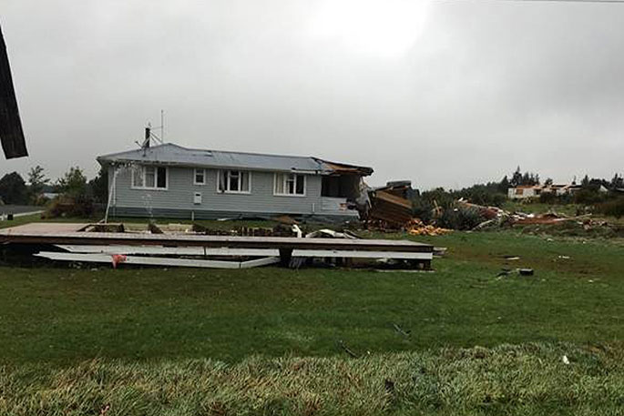
Meanwhile, tornados were spotted in Opunake and National Park Village, with Civil Defence reporting widespread damage including houses losing roofs.
At least nine schools in the area closed for the day due to the weather, and several flights in and out of New Plymouth were cancelled.
A road snowfall warning has been issued for the Central Plateau - SH1, SH49, SH4, SH47, SH46 - and the Napier-Taupo Road.
The NZTA is asking road users to take extra care while travelling, "as snow and ice can make the road more hazardous, especially in shaded areas and on bridge decks".
A trough which produced close to 6000 lightning strikes over the Taranaki region between 7-9am is about to head over #Auckland & much of the upper North Island. This squall line is likely a period of heavy rain along with gusts of up to 110km/h. More at https://t.co/GZIq9Jlbrw^AC pic.twitter.com/N39Mpx8CT2
— MetService (@MetService) April 9, 2018
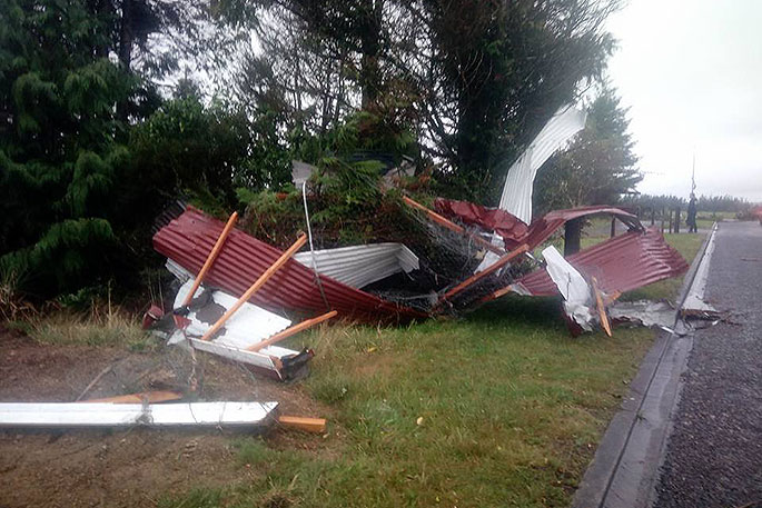 Photo from Tongariro taken by Damien Lee Kenyon.
Several clusters of thunderstorms across the North Island at 10:15 am:
— NIWA Weather (@NiwaWeather) April 9, 2018
⚡ Several offshore of Auckland/Northland.
⚡ Tongariro National Park.
⚡ Whanganui National Park.
⚡ Between Rotorua & Taupo. pic.twitter.com/b2jYR8VcPt
Gales for #Auckland this afternoon and evening. A low pressure brings strong, gusty winds especially to Auckland, Waikato and the Coromandel later today. Gusts of 120km/h possible. Tie loose objects down. https://t.co/Sd5C6lrsSL ^TA pic.twitter.com/3qfzaZepHF
— MetService (@MetService) April 9, 2018
Tornado in National Park Village
— MW Civil Defence (@MW_CivilDefence) April 9, 2018
Ruapehu civil defence and response agencies are responding to a tornado in National Park Village.
There's widespread reports of damage including houses having lost roofs.
Power is out. Council contractors and other services are responding.

0 comments
Leave a Comment
You must be logged in to make a comment.