There seems to be consensus now.
The famous Pink and White Terraces were destroyed by the 1886 eruption of Mt Tarawera. And it seems the former sites of the terraces are now beneath the modern Lake Rotomahana.
The eruption of Mt Tarawera, which devastated the surrounding countryside, destroyed several villages and was responsible for about 120 deaths.
It was the largest and most destructive volcanic eruption in New Zealand since the arrival of Europeans in the early nineteenth century.
The diary and hand-drawn maps of nineteenth century geologist, Ferdinand von Hochstetter, enabled NIWA scientists to confirm the former site of the iconic Pink and White Terraces at Lake Rotomahana.
Von Hochstetter conducted the only known formal survey of Lake Rotomahana before the Mt Tarawera eruption.
NIWA scientists Dr Andrew Lorrey and John-Mark Woolley evaluated Hochstetter's diary notes and reconstructed his survey sites and stations around Lake Rotomahana using LIDAR, or Light Detection and Ranging - a remote sensing system that uses light pulses to measure distance and topography.
They combined that information with sketches drawn by Hochstetter and a map published in 1862 to pinpoint the former location of the terraces.
NIWA scientists Dr Andrew Lorrey and John-Mark Woolley say their research agrees with previous findings by Professor Ron Keam and GNS Science that the former sites of the terraces are under the modern Lake Rotomahana.
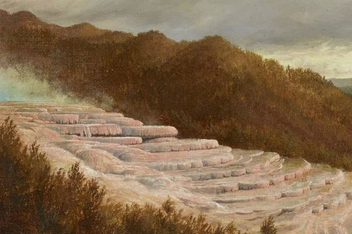
The terraces formed over thousands of years as silica-rich water emerging from springs and boiling geysers crystallised into giant tiered staircases.
The White Terrace covered more than three hectares while the smaller Pink Terrace was used for bathing on the lower levels.
The Terraces were a thriving tourist destination, attracting people from overseas, and described as the eighth wonder of the world.
Dr Lorrey says Hochstetter's survey bearings and sketches document Lake Rotomahana and the Rotorua landscape and include important details about the terraces, small geothermal features around the lake and some distant landmarks.
"From Hochstetter's material, supplied to us by Dr Sascha Nolden, we were able to resconstruct where former survey datums were located. We used those details to position the map he published to show the location of the terraces," says Dr Lorrey.
Hochstetter's notes also contains several other draft maps that Dr Lorrey says were progressively refined as he continued his work.
"You can see how he reconsidered two or three times how to draw things and how to orientate them. The published map is faithful to the diary measurements, and the results we obtained align to previous research on where the terraces might be."
Dr Lorrey says the outcome also demonstrates the accuracy and utility of historic documents for scientific research.

0 comments
Leave a Comment
You must be logged in to make a comment.