Police believe there are no survivors on White Island after it erupted on Monday, leaving at least five dead and multiple others injured.
There are still a number of people unaccounted for.
The volcano is monitored by GNS Science and its GeoNet project - a geological hazard monitoring system.
A statement from GeoNet about 4.30pm that "an eruption occurred at 14.11 local time as an impulsive, shortlived event and affected the crater floor. Activity appears to have diminished since the eruption.
"Our monitoring data shows that there was a short-lived eruption that generated an ash plume to ~12,000ft above the vent. Ash has covered the main crater floor as seen in our webcam images. Ash fall appears to be confined to the island and we do not expect more than a minor amount of ash to reach East Cape in the coming hours.
"Our monitoring equipment is still operating, and we have seen a steady decline in activity since the eruption. There remains significant uncertainty as to future changes but currently, there are no signs of escalation."
GNS volcanologist Geoff Kilgour says the initial eruption lasted a few minutes and was similar to a 2016 eruption.
"This is on the upper end of what we've seen, so it appears - it's still very early to tell how big it actually is until ... the dust settles - but it's similar to about April 2016 where a plume was generated about the same height. There were some rather substantial rocks that were thrown out and kind of a ground-hugging flow was sent across the crater floor to the sea which is about a kilometre away from the vent.
"We know that the ash has got to at least our camera which is very close to the coast, and we don't quite know exactly how it got there - either it's fallen out of the sky in a normal ash plume or it's come along one of these ground-hugging flows - but it's about the same size."
GeoNet's webcam images show volcanic ash had covered the main crater floor.
GNS duty volcanologist Steve Sherburn was alerted to the eruption by a display on his computer showing pressure levels on the island had changed.
"The next thing I looked at was the camera that we have on the shore near Whakatāne and that records images only every 10 minutes and so the next one that came up showed this large ... steam column with a bit of ash up above the island."
Inside the plume coming from the eruption would have been aerosols - droplets of other of other gases like sulphur dioxide and carbon dioxide, he says.
"What we have noticed is that the level of the water in the crater lake there has risen quite substantially since [the eruption]. Before and after pictures show (it was) something between five and 10 metres higher."
The eruption
Dr Sherburn says eruptions are "when the excess pressure [beneath the ground] is too strong to be to be kept in by the rock and other material in the crater area ... You get this sudden depressurisation, same as sort of taking the top off of a soft drink bottle or pulling the cork out of a bottle of champagne. It depressurises and the materials underneath rise very, very quickly.
"And in the case of a situation like today's eruption, it fractures and fragments all the overlying rock, some of it into really fine particles like ash. Some of it could be much, much larger particles - golf ball size, cricket ball size, pumpkin size, you know, it could be could be really large. Large eruptions can even throw things the size of small cars.
"Because the eruption has occurred close to - possibly from within the lake - there could be a lot of water projected at the same time so you can get really quite a mixture of material."
Dr Sherburn says GNS Science hoped what it saw over the next few days on the island would help determine if Monday's eruption was a one-off driven by steam pressure, or if there was magma involved.
Volcanic Alert Level
Directly after the eruption, the Volcanic Alert Level had been raised to 4. By about 4.30pm, it was decreased to Level 3.
The Volcanic Alert Levels range from 0 - no volcanic unrest - to 5 - major volcanic eruption.
On the scale, 4 means moderate volcanic eruption - hazards are present on and near the volcano. Level 3 means minor volcanic eruption - hazards are present near the volcano's vent.
Increased alert level before the eruption
In mid-November, the alert level lifted to 2.
At the time, GNS volcanologist Michael Rosenburg says there had been an increase of sulphur gas from deep inside the volcano and an increase in tremors.
He says the changes may or may not be a signal that something is happening.
"White Island volcano is really complicated and just because one thing changes, it doesn't necessarily mean that everything else will change and it doesn't necessarily mean that this is going to lead to an eruption."
Dr Sherburn says GNS had seen increased seismic activity - specifically volcanic tremor - over the past month or so.
"But it's been quite variable, particularly last week. For most of 2019, we've had higher amounts of sulphur dioxide, which is one of the common volcanic gases coming out of the volcano," he said.
"But we haven't, for example, seen the disturbances in the volcanic crater lake. It's been quite stable for for several weeks. Some of the temperatures from some of the steam vents we've measured on the island have been going down, not going up."
GNS Science's Dr Ken Gledhill says usually what happened was the eruption would be followed by a period of quiescence - inactivity.
Earlier in the evening on Monday, Dr Gledhill says it looked like the volcano had quietened down, but GNS Science could not be certain there would not be another eruption in the next 24 hours.
"On the scheme of things for volcanic eruptions, it's not large, but if you are close to that it is not good."
At about 9pm, Dr Sherburn also says the volcano still looked "quiet" based on monitoring.
GNS Science and GeoNet will continue to monitor the island.
Whakaari/White Island eruption update #3 - Our sympathies are with those families affected by the Whakaari/White Island eruption. We will continue to monitor the island for any changes in volcanic activity. We expect to put out our next update tomorrow morning, 10 December 2019.
— GeoNet (@geonet) December 9, 2019
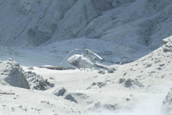
There are three web cameras observing the volcano and one seismograph and a microphone to detect volcanic explosions. Some of those cameras were caked in material after the eruption, affecting the images they sent out.
GNS also makes three monthly visits to test water, gas and soil, as well as to make surveys of surface deformation.
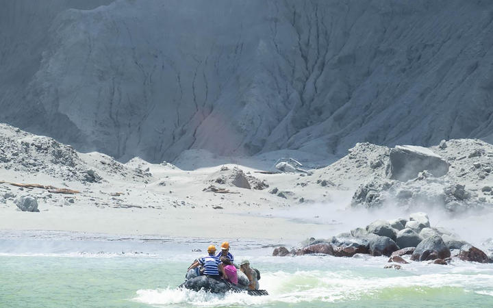 White Island Tour operators rescuing people minutes after the eruption. Photo: MICHAEL SCHADE
Describing Whakaari / White Island's volcano
According to GNS, Whakaari / White Island has been New Zealand's most continuously active volcano over the last 40 years.
The uninhabited island is about 2km in diameter and lies about 48km from the coast of the Bay of Plenty.
Here's what GNS had to say: "Although 70 percent of the cone is under the sea, the highest point reaches 321m altitude. Most of the island is occupied by the Main Crater, with the crater floor being less than 30m above sea level.
"White Island has been active for at least 150,000 years, It is a stratovolcano, (composite cone volcano) made of layers of andesite lava flows and pyroclastic deposits (tephra). Since human settlement in New Zealand there has been continual low level activity and small eruptions.
"From 1975 until 2001 there were frequent small eruptions making this the island's most active period in hundreds of years. Ash and gas plumes rose as high as 10km, lava bombs and blocks were thrown into the sea and occasionally the glow of red hot rock was visible at night from the Bay of Plenty coast.
"Gases dissolved in the magma escape and rise towards the surface where they mix with, and heat the groundwater beneath the crater floor. This produces fumaroles, and the white steam/gas cloud which is usually present above White Island. This acidic cloud can sting the eyes and skin, affect breathing and damage equipment and clothes."
Sulphur mining took place on the island at times between the 1880s and 1930s. In 1914, 11 miners were killed by an avalanche when part of the crater rim collapsed.
![]()

0 comments
Leave a Comment
You must be logged in to make a comment.