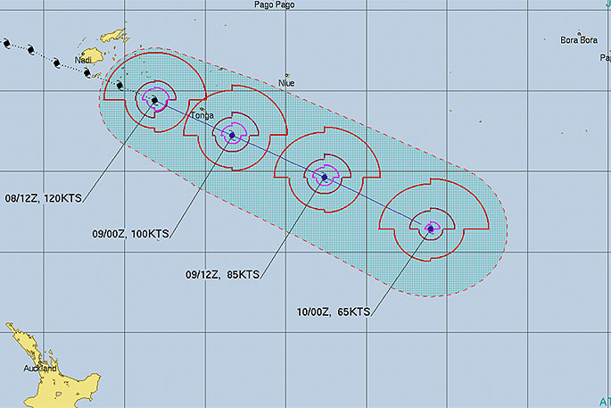
Overnight severe cyclone Harold strengthened further despite moving away from the equator and tracking south east towards Tonga.
It's bad news for the small nation, no stranger to passing cyclones and ex-cyclones. However a Category 5 monster is rare.
'It's almost unheard of to see a cyclone tracking south away from the equator, weakening, then suddenly returning back to Cat 5 so far south,” says WeatherWatch.co.nz head forecaster Philip Duncan.
'Harold is tracking in a well known cyclone path and warm seas and ideal atmospheric conditions will be fuelling this storm."
Harold gained power as it departed Fiji last night, moving away from land and over very warm sea waters just shy of 30 degrees. It's here that it re-energised back to the most power level, Category 5.
There is some good news for Tonga this morning – the centre of the storm has remained south, meaning the most destructive part of the storm is just shy of the main island. The bad news is that coastal flooding could be ‘catastrophic' in some spots and wind damage may also be significant.
By this afternoon Harold will be in open waters of the South Pacific and pose only a threat to cargo or fishing boats at sea.
This will be our final update on Cyclone Harold with no more nations exposed to the storm.
Incredibly, this will also be the first time WeatherWatch.co.nz has ever stopped daily tracking such a high end South Pacific cyclone, simply because it's so far south and by the end of today will be no where near land and moving further out to sea.
View more maps and tweets from this morning here: https://www.weatherwatch.co.nz/content/stunning-twist-cyclone-harold-returns-to-category-5-strength-as-it-passes-tonga

0 comments
Leave a Comment
You must be logged in to make a comment.