Questions are being asked over whether all of Whakatane needed to evacuate during the recent tsunami threat.
Nearly the whole town scrambled for the hills but according to maps on the Bay of Plenty Civil Defence website, only about a third of the town was in potential danger.
Maps show that most of Whakatane south of Domain and Landing roads would have been safe in a tsunami up to 8.25 metres high. The predicted tsunami on March 5 was of between one and three metres.
The mapped 'safe zone” includes both Whakatane secondary schools, Allandale and St Joseph's primary schools and Whakatane Hospital.
Community and emergency workers are now asking, should an alert come again, should people in this part of town stay where they are or evacuate just to be safe?
Police raised the point with Minister for Emergency Management and East Coast MP Kiri Allan at a meeting on Friday.
Allan met with civil defence staff, police and volunteer fire fighters at Whakatane District Council to hear from them on how they thought New Zealand's largest evacuation event went.
Eastern Bay road policing manager Chris Howard summed it up in one word - 'chaos”.
Mr Howard says as soon as the evacuation alert hit people's phones, the roads in Whakatane were gridlocked.
'Everyone wanted to drive, no one wanted to walk, there was one person per car,” he says.
Police raised the issue that the original alert did not specify how far from the coast people needed to evacuate and the estimated time of arrival of the tsunami.
Mr Howard says the fact that some evacuated when they possibly didn't need to, contributed to the traffic gridlock and could have prevented those who did need to evacuate from getting to safety if a tsunami did eventuate.
He gave the example of it taking Trident High School students 20 minutes to cross Valley Road to walk up Gorge Road, which impeded the flow of traffic.
He notes that, according to the civil defence tsunami map, these students would have been safe at school.
'We would like to see some education put out there that people can walk or cycle if this happens again,” he says.
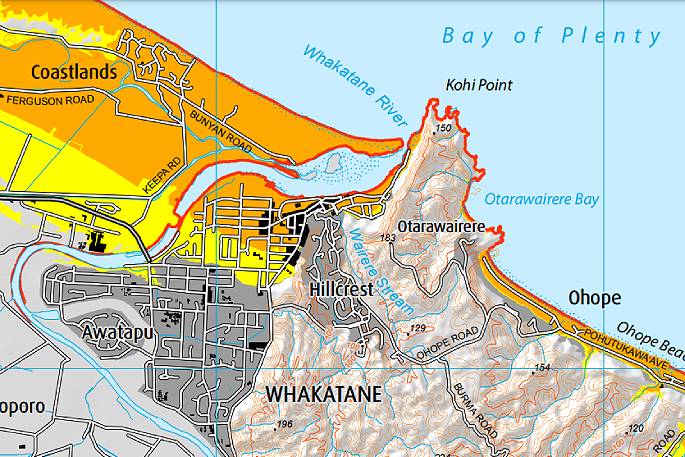 The coloured areas on this map taken from the Bay of Plenty Civil Defence website indicate which areas of Whakatane are at risk from a tsunami up to 8.25 metres high. SUPPLIED.
Senior Sergeant Al Fenwick says police did not have the civil defence map available on the day so were making allowances for everyone to evacuate.
However, there might not be as long a time frame next time so he was worried that if people who didn't need to evacuate did so again, there might be loss of life due to the blocked escape routes.
An example of this is Awakeri School evacuating, which is around 10 kilometres from the coast.
'With the whole town evacuating, it made our lives harder,” says Fenwick.
'The alert said to get to higher ground, and it would be great if it could be more specific about how close you have to be to the coast to be in danger. There was widespread panic with people at Awakeri and Waimana evacuating.”
The police stressed that they are not blaming those who did evacuate and say it's human nature to respond that way.
Police also note there was a communication breakdown and the public knew before them that the threat had passed.
Allan says there will be a review into how the evacuation was handled, as there is with all events like this.
'My thoughts are, though, did people know what to do and did they have the means to do it? The answer is yes across the board,” she says.
'I would still err on the side that it is better people leave home than stay.”
Allan says during a national event like this, messaging is very broad and messages sent to the public just can't go into that level of detail requested.
She says staff made decisions with the best data available to them at the time and these decisions were then communicated almost immediately to the public.
She is concentrating on whether, had the tsunami eventuated, there would have been loss of life or not.
'Your comments will all feed into the national review which will be publicly released,” she says.
Local Democracy Reporting asked Bay of Plenty Civil Defence if it would like those living in the grey areas on the map to evacuate in any future events.
Some members of the public say they had stayed home after viewing the maps but are wondering if they made the right decision.
A spokeswoman responded says it's too early to say.
'The event was a very valuable opportunity to see how a large-scale evacuation works in reality,” she says.
'A number of debriefs are being held at a local, regional and national level, so it's too early to state what that advice would be though there will be public education programmes that fall out of this in due course.”
![]()

1 comment
Evacuate With Brain
Posted on 17-03-2021 10:56 | By Yadick
Tis better to err on the side of caution. Had a major tsunami hit and the whole town hadn't been evacuated there would have been questions asked, charges thrown around, anger would be rife, slagging off a useless system, . . . To those that were inconvenienced at the possibility of saving your life or that of your loved ones, you have my heartfelt condolences . . . IMO the evacuation announcement was good. I took 4 neighbors with me to fill my car. Evacuation doesn't mean leaving your brain behind. I did learn not to wear jandals though.
Leave a Comment
You must be logged in to make a comment.