Dotted around the deep ocean, a buoy tsunami warning system is helping to keep New Zealanders safer from tsunamis.
The buoys, which were deployed in the past 15 months, had a chance to prove their worth during the recent large undersea earthquakes in the South Pacific.
The Dart – deep-ocean assessment and reporting of tsunami – buoys improved the accuracy of tsunami impact forecasts.
Following the large earthquakes on March 5, the Dart network allowed the National Emergency Management Agency (Nema) to cancel the tsunami warning several hours earlier than would have been possible if officials relied on coastal tidal gauges alone.
The buoys also provide more accurate estimates of the size, location and timing of tsunamis at New Zealand's coastline, says Nema spokesperson Anthony Frith.
How the buoys work
GNS Science earthquake and tsunami researcher Dr Bill Fry says the Dart network measured a tsunami in the open ocean, far away from the complicating effects of coastlines and typically long before many coastal impacts.
Data from the buoys was sent over satellite communications in near real time to GeoNet and to the Pacific Tsunami Warning Center in Hawaii, says Dr Fry.
The quality of information picked up at Dart buoys depended on how favourably located they were. It was enough to give a good picture of the earthquake that generated the wave, and a good indication of tsunami size, but it was not going to be perfect because the wave wasn't being captured everywhere.
Given the limited information shortly after an earthquake, early tsunami forecasts were quite conservative. 'Then as we get more information we can become less conservative, so the uncertainty is reduced,” says Dr Fry.
Tsunami were small at the surface and fast moving across open ocean. When they reached shallower water, they slowed down and grew in height.
With three large earthquakes on March 5 – the East Cape event, followed by 7.4 and 8.1 magnitude earthquakes in the Kermadec Islands – understanding the tsunami activity was particularly challenging.
Waves generated by earthquakes tended to bounce around the coast and harbours and stay there for quite a while, says Dr Fry.
Early understanding of the tsunami hazard on March 5 had been 'pretty good". As time went on the uncertainty reduced, and there was an 'ever evolving picture of increased comfort with the forecasts”.
Much more was known about the March 5 tsunamis than would have been the case if the Dart buoy network was not in place, says Dr Fry.
Within about 30 minutes of the larger of the Kermadec Island earthquakes, tsunami information had been coming in from two Dart buoys, says Dr Fry. It took about an hour for a tsunami wave to reach North Cape.
Tide gauges recorded some tsunami information in coastal waters, but they didn't capture everything, and work was being done to look for evidence of the tsunamis and how far inland and above sea level they reached.
How buoys help with other earthquakes
The Dart network also measured tsunami waves generated by a 7.7 magnitude in the New Caledonia area on February 11, says Dr Fry.
Within five to 10 minutes of that event, earthquake data had allowed the National Geohazards Monitoring Centre (NGMC) to determine a possible threat to New Zealand.
The understanding of the size and type of earthquake was further refined through links to international agencies within about 45 minutes.
The Tsunami Expert Panel rapidly used the available earthquake data to run initial models of the tsunami waves prior to their arrival in New Zealand.
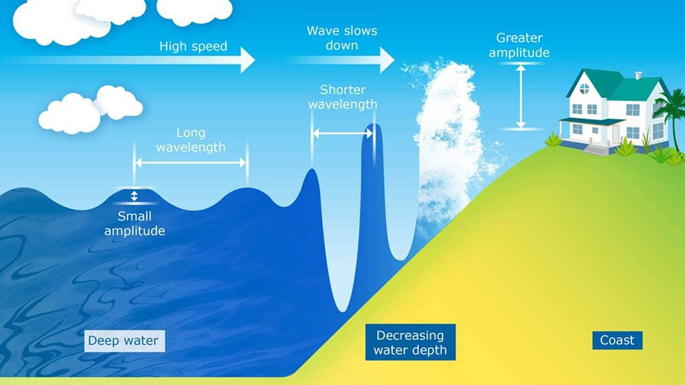 In deep water, a tsunami moves very fast and has a long wavelength and a small amplitude. As it enters shallower water, it slows down and the wavelength decreases. This causes the wave to become much taller. The University of Waikato/Supplied.
When water waves were measured on the Dart and tidal gauge networks from the February 11 tsunami, they were larger than expected from analysis of the earthquake data, says Dr Fry.
'These observations allowed us to improve the forecasts, by highlighting that the earthquake was either bigger and/or more complex than we originally thought.
Where are these buoys?
The Dart buoy network provided improved safety to all countries with borders on the Pacific Ocean, with a focus on New Zealand and its closest neighbours, says Dr Fry.
Eight of 12 planned Dart (Deep-ocean assessment and reporting of tsunami) buoys have been put in place along the Tonga-Kermadec-Hikurangi trench system, which stretches northeast under the sea from near the top of the South Island to near Samoa.
Three of those buoys are off the east of the North Island between Wellington and East Cape, with the others in a line stretching far out to the northeast.
The plan is to deploy the remaining four buoys this year, depending on favourable ocean and weather conditions and shipping availability.
Three of the remaining buoys will be placed to the northwest of New Zealand, around New Caledonia and Vanuatu, and the other one will be well out to sea off the east of the upper North Island.
Nema's Frith says the Dart buoys could also provide rapid confirmation that a large earthquake, or other possible trigger event, had not generated a tsunami.
'We can determine sooner that there is no threat and people do not need to evacuate, or give people who self-evacuated when they felt a long or strong quake the all clear to return home.”
The science behind buoys
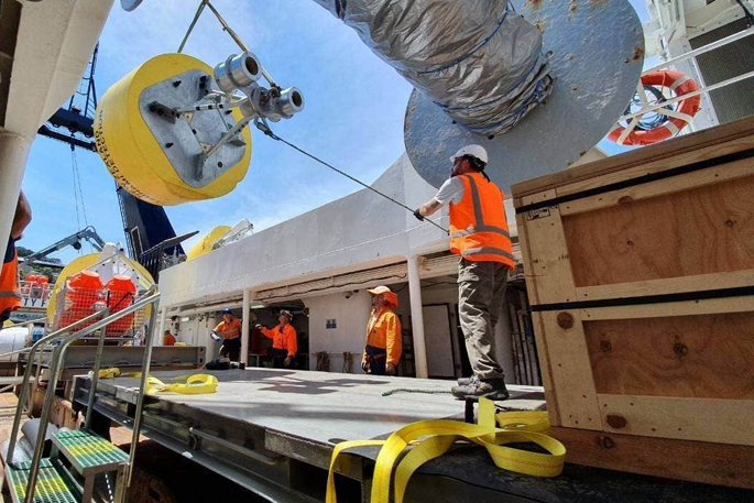
Each buoy has two main components – a bottom pressure recorder that sits on the seafloor, and a large, yellow float on the surface above.
Deploying both components required a sophisticated mix of precision positioning on the high seas, sophisticated marine mapping below and a deep understanding of ocean currents, says Susan Pepperell from Niwa, which is involved in the Dart project.
The equipment on the seafloor recorded the height of the ocean above it. If a measurement was outside normal parameters, it would send a special signal to the surface float.
That was when the system flicked into 'event mode” – a trigger that meant it would update a GNS server every few minutes rather than the usual once an hour. Event mode could also be triggered remotely if it was thought a tsunami may be headed towards a buoy.
When warnings will come too late
Tsunami from local earthquakes close to New Zealand, such as the first large event on March 5 – a 7.3 magnitude event off East Cape – could arrive within minutes, before there was time to issue an official warning, says Frith.
Even with the improvement in forecasting provided by the Dart buoys, Nema emphasised the importance of following the Long or Strong: Get Gone advice.
People near the coast should immediately move to high ground or inland if they:
- Feel a strong earthquake that makes it hard to stand or a long earthquake that lasts more than a minute
- See a sudden rise or fall in sea level
- Hear loud or unusual noises from the sea.

0 comments
Leave a Comment
You must be logged in to make a comment.