UPDATE 10.12AM: Several Auckland schools have close and residents in Northland and Auckland are urged to take shelter as a severe thunderstorm and heavy rain travels down the North Island.
MetService has issued a severe thunderstorm warning for the areas of Kaipara, Far North, Whangārei and Rodney.
A severe thunderstorm watch is already in force for Northland, Auckland, Great Barrier Island and the Coromandel Peninsula.
More than 4000 lightning strikes were recorded in the Auckland and lower Northland regions, with more than 700 in the space of five minutes earlier this morning.
The National Emergency Management Agency is urging people to take shelter inside, away from windows as the weather hits early this morning.
A police spokesperson says police are advising motorists across Auckland to delay their travel, if at all possible, this morning.
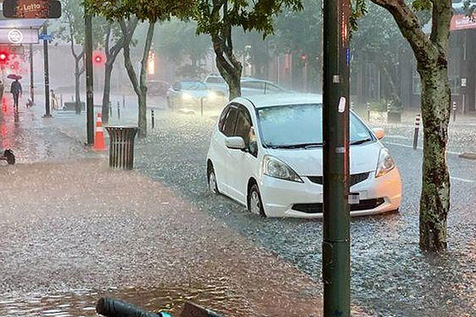
"There have been a number of calls for assistance to emergency services across the city where vehicles have become submerged," says a police spokesperson.
"Police urge motorists to drive with extreme caution, particularly in areas where there is surface flooding as there could be hidden hazards.
"If you can delay travel, we would advise you do so until the weather event has passed."
Follow the latest live updates:
EARLIER:
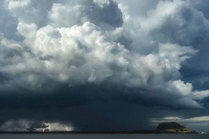
 Thunderstorm, File photo. Photo: Twitter / Brennan Mullan.
People, particularly in Northland and Auckland, have been urged to take shelter this morning as a severe thunderstorm travels down the North Island.
MetService has issued a severe thunderstorm warning for the areas of Kaipara, Far North, Whangārei and Rodney.
A severe thunderstorm watch is already in force for Northland, Auckland, Great Barrier Island and the Coromandel Peninsula.
There is also a severe weather warning in place for the Bay of Plenty.
Several Auckland schools including Orewa College and Red Beach School have been forced to close this morning due to high surface flooding.
Incredible amount of lightning observed in the Auckland and lower Northland regions.
— NIWA Weather (@NiwaWeather) March 20, 2022
Past hour: 4000+ strikes
Past 5 minutes: 700+ strikes
Expect very heavy rain, along with the thunderstorms, for the next couple of hours. Need to watch for urban flooding. pic.twitter.com/ORKiZXgWpD
The National Emergency Management Agency is urging people to take shelter inside, away from windows as the weather hits early this morning.
Anyone on the water should return to land and loose objects should be secured.
Metservice meteorologist Kyle Lee told Morning Report in some areas as much as 80-90 millilitres of rain fell in just an hour.
He says the storm has made its way down the island passing through Waipu to Ahuroa before touching down in Waipu Cove and Orewa around 7.30am.
He says MetService will be re-evaluating their warnings and advice for residents as the storm rolls down the North Island.
Lee says the southern areas of Northland and the northern part of Auckland are at risk of potential tornadoes, although the risk is low.
"With those places being quite dry as well there should be quite a lot of surface flooding as well because a lot of the rainfall is just going to sort of go right off the surfaces there and not really soak in."
He urges those affected to stay up to date with the latest developments on the MetService rain radar.
@MetService issued a SEVERE THUNDERSTORM WARNING for the following areas in the Auckland Region: KAIPARA, RODNEY & ALBANY.
— Auckland CDEM (@AucklandCDEM) March 20, 2022
Thunderstorms are expected to be accompanied by very heavy rain.
Latest info can be found here: https://t.co/WTIXG6y6dx or by following @MetService
^KM pic.twitter.com/xON4G4DEC0
The line of thunderstorms was first spotted offshore as it approached the Bay of Islands just after 1am.
Overnight, Purerua, in Bay of Islands, recorded just over 100 millilitres of rain in two hours.
MetService meteorologist Jessie Owens says that was exceptional rain, and the hardest hit part of Northland.
Owen says most of the rain has cleared the Far North and is heading towards Auckland now.
⛈⛈⛈
— MetService (@MetService) March 20, 2022
Intense rain continuing to move southeast.
Latest Severe Thunderstorm Warning https://t.co/GeH6tLulff
3500 strikes in the last 2 hours pic.twitter.com/ln24ha1Ydo
Fire and Emergency says it has three flooding-related callouts in Auckland this morning.
A spokesperson says three properties in the suburb of Orewa, on the Hibiscus Coast, were affected by heavy rain in early hours of this morning.
A severe thunderstorm watch remains in force in the area.
WeatherWatch forecaster Philip Duncan told First Up tornadoes are possible in Auckland as thunderstorms and torrential rain lash the North Island this morning.
Severe weather warnings are in force for much of the upper North Island, people are being warned flash flooding and slips could be hazardous.
Duncan says wild winds could strike the so-called "tornado alley" of the north-western side of Auckland and the Waitematā Harbour.
He says forecasters spotted the potential for tornadoes in this weather event last week, which is unusual.


0 comments
Leave a Comment
You must be logged in to make a comment.