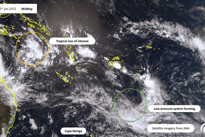
While conditions around New Zealand are relatively settled, MetService is keeping an eye on the Tropics.
There is potential for tropical cyclone formation on Wednesday/Thursday near Vanuatu. Meanwhile, a separate low pressure system is forecast to bring more heavy rain to the Tairāwhiti / Gisborne region.
There is currently a tropical low in the Coral Sea to the west of Vanuatu and MetService is forecasting favourable conditions for tropical cyclone development during Wednesday and Thursday.
Should a tropical cyclone eventuate, it will be the second of the tropical cyclone season (November – April) following Hale.
This system is then expected to track to the southeast affecting southern Vanuatu.
It's not forecast to affect New Zealand this week, butr MetService meteorologists are keeping a close eye on the situation as it develops and will have a better idea of future tracks once the system has formed.
Closer to home, a different low pressure system is expected to approach the country from the north, passing near East Cape late Wednesday and into Thursday.
'This system will bring strong east to southeasterly winds and another period of rain to already sodden northeastern areas,” says MetService meteorologist Jessie Owen.
There is currently a Heavy Rain Watch in force for the Tairāwhiti / Gisborne region from 10am Wednesday until 2pm Thursday and this may be upgraded to a Heavy Rain Warning as the low approaches.
There is also a risk of heavy rain in northern Hawke's Bay and severe gale east to southeasterly winds in eastern Bay of Plenty.
The low will then move away from the country to the east on Friday.
The rest of New Zealand can expect relatively settled weather for the next few days as a high pressure system slowly loosens its hold on the country.
Plenty of sunshine and warm temperatures are forecast for Monday, with the hot spots being Southland and Central Otago with high temperatures expected to reach the high twenties following a
'Alexandra reached 30.9°C and Wanaka reached 29.7°C on Sunday afternoon, a good six degrees above their average January daytime maximum temperatures.”
On Tuesday, a weak front moves up the South Island briefly bringing showers and cooler temperatures in its wake before settled warm weather returns to the South Island for Wednesday and Thursday while the low pressure system affects the North Island.
A change is in the air however as a cold front is expected to bring rain to the South Island on Friday and drop the temperatures back down to the low twenties.
 Image: MetService.


0 comments
Leave a Comment
You must be logged in to make a comment.