Saturated parts of the upper North Island look likely to be able to continue drying out during the week ahead, but a new tropical cyclone could be looming on the horizon.
A low over the Coral Sea had the potential to develop into a tropical cyclone that could reach New Zealand by Sunday, MetService says on Monday. A very favourable environment meant it could reach severe tropical cyclone intensity (category 3 or above) while over open waters.
The risk of the system developing into a tropical cyclone from overnight Tuesday onwards was high.
'The system is expected to start moving southeast later in the week, tracking to the far south of New Caledonia, then possibly towards the upper North Island late Sunday or early next week,” MetService says.
But at this early stage there was considerable uncertainty about the future track of the system.
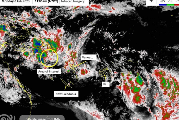
Image: MetService.
On Monday, the tropical low was just to the south of the Solomon Islands.
'If this system does pass close to the North Island, it will be another significant weather event potentially affecting vulnerable areas which are still recovering from recent severe weather,” MetService says.
”Impacts for New Zealand will be highly dependent on the path the cyclone could take, but may include strong winds, heavy rain, and large swells on eastern coasts if it passes close to the North Island.”
For much of the country the next four or five days, at least, are expected to be largely dry, although showers are possible some days.
MetService had no severe weather warnings or watches on Monday morning, while the only possibility of any severe weather between Wednesday and Saturday was considered to be a chance of heavy rain in the very bottom of the country.
A large high was expected to lie over the Tasman Sea on Wednesday. It was expected to begin moving onto the country on Thursday and remain until Saturday.
Well above average temperatures recorded in recent days, particularly in the South Island, will ease by Wednesday.
Niwa recorded its warmest day of summer so far – 35.6C at Middlemarch, northwest of Dunedin - on Saturday, while Milford Sound recorded its warmest temperature on record on the same day – 29.4C.
The temperature reached within a whisker of 34C in Christchurch on Friday and Saturday, and topped 32C on Thursday. It hit 29C on Sunday, and MetService predicted it to reach that level again on Monday and Tuesday.
That would be six unusually warm days in a row for the South Island's largest city, but MetService is expecting cooler days to be on the way by Wednesday, and by Thursday the forecast high is just 16C.

0 comments
Leave a Comment
You must be logged in to make a comment.