Update, 2pm: Due to unexpected flooding, sections of State Highway 2 in the Karangahake Gorge may need to be closed later today.
Motorists are advised to consider travelling on Monday afternoon if possible.
State Highway 25 between Whangamata and Waihi has the southbound lane blocked due to a fallen tree in Waiharakeke. Drive with caution along this route.
Due to multiple slips, fallen trees and debris, SH25 is closed between Kuaotunu and Whitianga. Delay your journey.
Also, because of multiple slips, fallen trees and debris on the road, please dive with extra caution - essential travel only) - on SH25 between Te Rerenga and Kuaotunu or delay your journey
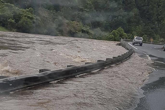
Earlier, 6.45am: Power outages, downed trees, flooding are some of the early impacts being seen as Cyclone Gabrielle lashes the upper North Island.
Bay of Plenty and Waikato can expect rain with heavy falls, torrential falls in the evening then easing overnight.
The Coromandel peninsula will likely have the highest totals of rainfall and already experienced power outages on Sunday. The two regions will also experience strong to gale southeasterly winds.
Winds are forecast to tend southwest in the evening just north of Auckland, with severe gales possible especially in the west. In the evening winds tend more easterly for Bay of Plenty.
Due to a tree blocking lanes on State Highway 25 north or Coroglen, caution is advised along this route.
A fallen tree is also blocking both directions of SH25 between Coromandel and Whitianga.
Due to multiple slips, fallen trees and debris on the road, SH25 is closed to all travel between Thames and Whitianga as the highway is currently not safe. Delay travel and stay safe.
Due to a slip on SH25 Whakatete Bay, the road between Thames and Coromandel is open under a priority give way. A 50km temporary speed restriction is in place and caution is advised in the area.
A fallen tree has been reported across the road on SH26 between Paeroa and Kopu.
Caution is also advised in the Waioeka Gorge as there have been rock falls along SH2 between Opotiki and Gisborne.
A tree has fallen across the highway between Tirau and Rotorua on State Highway 5.
Warnings for today's storm can be found here.
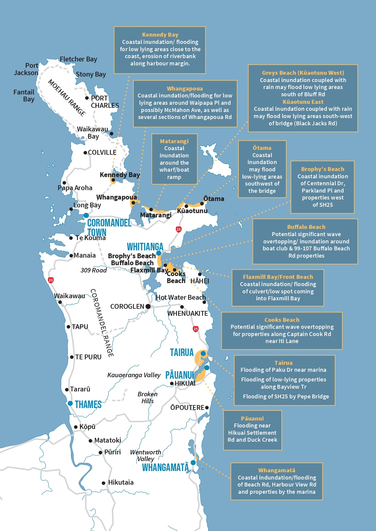
Coromandel area
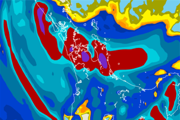
A red wind and rain warning for Cyclone Gabrielle is in force for the Coromandel area.
From Sunday February 12 until Tuesday morning February 14, we can expect 400mm of rain and gale force easterly winds with gusts exceeding 130km per hour across the Coromandel peninsula.
Widespread surface flooding, coastal storm surge waves in low lying areas, land instability, power outages, road closures, trees and debris falling and damage to property are certain across many parts of our district.
This map shows areas that are most at-risk during the storm event.
Western North Island (including Central North Island)
Cloudy with spits of rain, becoming more persistent from afternoon, heavy rain later or overnight. Southeasterly winds strengthen during the day, coastal gales likely from evening, perhaps severe.
Highs: 14-20
Eastern North Island
Rain, torrential falls about Gisborne spread into Hawkes Bay during the afternoon then Wairarapa overnight. Southeasterlies strengthen, gales likely with heavy rain, severe coastal gales possible especially later in the day.
Highs: 18-21
Wellington
Mostly cloudy, chance of a spit, rain moves in overnight with gusty southeasterlies becoming strong. Gales possible overnight especially through Cook Strait.
Highs: 20-21
Marlborough & Nelson
Cloudy with showers for Marlborough, perhaps some rain at times, especially overnight. Nelson has partly cloudy skies, a few spits from afternoon. East to southeasterly winds freshen.
Highs: 19-23
Canterbury
Some sun but cloud will start to thicken up from this afternoon, a few light showers start to move in especially north of Banks Peninsula. Overnight rain for the Kaikoura areas. East to northeasterly winds freshen.
Highs: 19-24
West Coast
Mostly sunny, a touch of high cloud especially in the north. Light winds.
Highs: 24-27
Southland & Otago
Morning cloud or fog then mostly sunny, afternoon southerlies for Southland, afternoon north easterlies for coastal Otago. A warm afternoon inland. Highs: 22-29

0 comments
Leave a Comment
You must be logged in to make a comment.