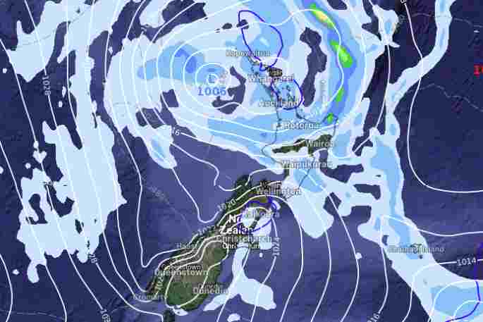
A low pressure system and front in bringing unsettled weather to the North Island today, with warnings of thunderstorms for Coromandel and Bay of Plenty.
At 12.52 pm, the MetService weather radar detected severe thunderstorms near Te Puke, Motiti Island, Pukehina and Paengaroa. A Severe Thunderstorm Watch that had been in place since 10.20am is now lifted for Bay of Plenty.
The South Island has high pressure sneaking in so the weather is calming down but it is cold, says a WeatherWatch spokesperson.
North Island
"Showers south of the Waikato with south to southeasterly winds, rain for Bay of Plenty may be heavy then easing this afternoon," says a WeatherWatch spokesperson.
"Parts of Hawkes Bay and Gisborne may be dry this morning then rain moves in as southerlies freshen.
"Late afternoon or evening showers will clear in the southwest (Taranaki through to Kapiti).
"Snow may get down to 800m later this evening about the Central Plateau.
"Auckland northwards will see showers, some may become heavy with thunder and hail this afternoon then easing evening as light winds change south to southeast.
"South to southeasterly winds through Cook Strait and pushing into Taranaki especially about coastal parts will be gale to severe gale."
South Island
There is cloud in the far south today. In the east, a few showers are about the coastal fringe in spots although a majority are dry.
"It's only north of the Rakaia River that showers are a little more frequent but still quite coastal. The ranges of North Canterbury catch slightly more frequent showers and these spread inland a little more with a few snow flurries to 500m.
"Tasman and the Marlborough Sounds sees showers clear this morning then sunny spells increase. The West Coast has a sunny day with southeasterlies.
"Some inland areas like the Mackenzie Country and parts of Central Otago will likely be frosty again overnight."

0 comments
Leave a Comment
You must be logged in to make a comment.