Flooded homes, threatened highways, and months of anxiety are what Rotorua's lakeside communities are battling as the ground is saturated and the lakes are full.
Local Democracy Reporter Laura Smith reports on the widespread impact of months of heavy rain.
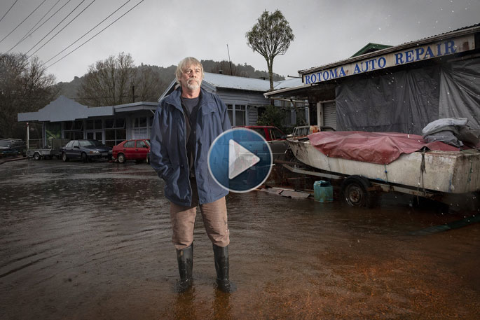
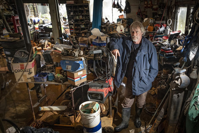
Bryce Allan has been working around the clock for months to keep water out of his business - he has six pumps going at once to clear the rising waters.
He shows Local Democracy Reporting around his water-logged Rotoma Auto Repair garage, where 100mm of water has accumulated.
There were thunderstorms the previous day and more rain is on the way.
Weather forecasts now unsettle him. He feels anxious about the possibility of more water 'screaming” into his business.
Rotorua has had the wettest January to June since 1963, with 1435 mm of rain falling across the district and lakes.
But it's not overflow from the lake that Allan's battling - yet.
Allan has owned his Rotomā property for 40 years but until March he did not know there was a geothermal spring under his garage.
The geothermal spring began to rise to the surface as a result of rising groundwater levels caused by the record rainfall.
With little soakage, the ground was saturated following the unusual frequency of cyclones and heavy rain events.
Now, the water can be 'too deep for gummies” and he was using six pumps at one time to control it.
He hasn't worked since March.
Before he managed to source a 40,000 litres an hour diesel pump that he switched on every 12 hours for twenty minutes, he was up every hour in the night to make sure the water level was under control.
'I was shattered.”
 Not been able to work since March, Bryce Allan stands in his flooded garage. Photo / Andrew Warner.
The mechanic now has a system: when the water outside his shop reaches a white line on a road cone he switches the large pump on.
Water from the geothermal spring has a surprising effect on Allan's equipment.
Looking around the garage you might have thought Allan's tools and parts were decades old, but in reality, the geothermal water has corroded the metal, turning it a vivid orange.
It left what Allan called 'rusty custard”.
His worry going forward is what will happen if the lake rises a few millimetres more to road level.
'It's going to get harder and harder to get the water out of here.”
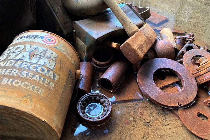 Bryce Allan calls the result of the geothermal water "rusty custard". Photo / Laura Smith.
As well as preserving his business, Allan is also trying to keep water from his elderly neighbours' homes.
Rotorua Lakes Community Board chairman Phill Thomass both spellings correct says Allan is a hero for this.
Thomass spoke to Local Democracy Reporting after late June thunderstorms.
Heavy rain falls as he explains the weather has raised lake levels, particularly for the lakes with no outlet such as Rotoehu and Rotomā.
'Every time it rains, the water level just goes up and up.”
Rain the night before resulted in both lakes rising more than 100mm, he says.
'We already have some properties flooded out there, it means more properties are getting closer to being flooded ... it also means groundwater is getting higher and higher.”
This means like in Bryce Allan's case, water is 'bubbling out of the ground”.
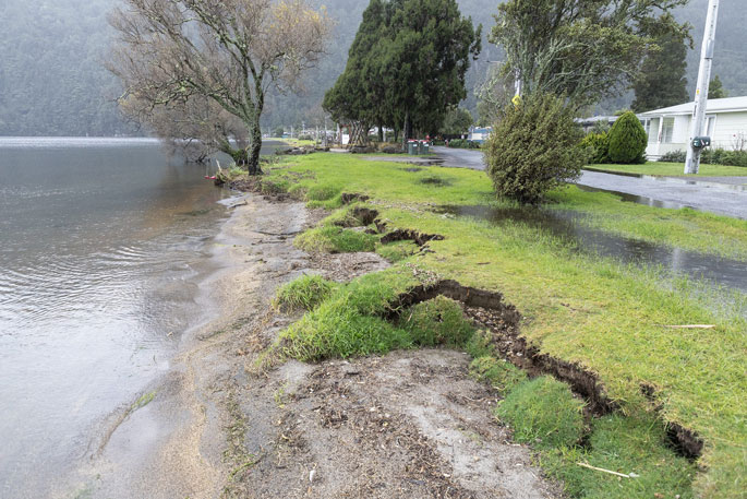
Maryann McCormick bought her Rotoiti lakeside property in 2013 and has never seen rainfall so heavy as she has in the past few months.
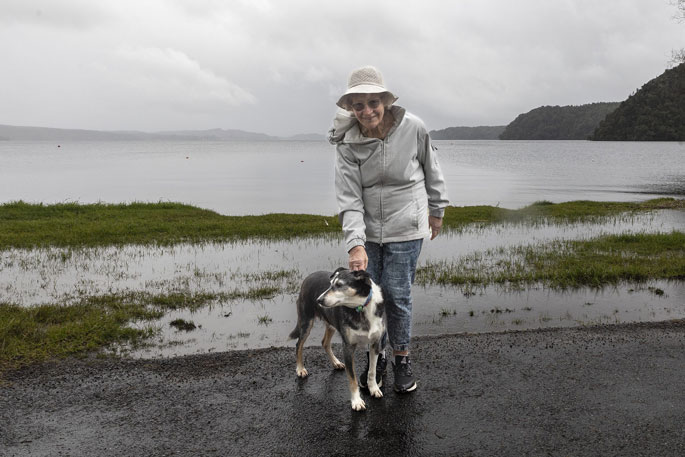 Maryann McCormick with her dog Skye outside her Lake Rotoiti property. Photo / Andrew Warner.
She does not believe the lake level will rise to a point where it reaches homes on Tamatea St, the road that runs alongside the lake's edge, because the water level can be lowered via the control gates at Okere Falls. Unlike its lake neighbours, water levels at Rotoiti can drop again quickly.
However, a creek running behind the row of houses is overflowing into gardens.
'All the properties are waterlogged at the back.”
She wonders if the creek can be widened or dredged.
The houses and the wetland are on privately owned land and any work will need resource consent.
Rotoehu home-owner Joan Blair spoke to Local Democracy Reporting a month ago, describing how her dream retirement home had turned to a nightmare.
She and her husband paid $30,000 to raise the piles of the house to keep it dry, and she said on Friday this had done the trick.
Water retreated only for it to come back up as it rained. It had not gotten any worse.
'We have to be sensible about it and accept it. Letting it kill you isn't doing any good either.”
She felt for other residents permanently living in the community who were facing long travel distances as roads closed with flooding.
Looking to the past
The strategy group is looking at long-term solutions and he says any solution involving engineering would come with a significant cost.
'And at this stage, we don't want to put that burden on ratepayers and we're unclear whether we could find that money from the Government.”
Lake levels reached similar levels five decades ago, he says.
According to the regional council data, water levels peaked at 317.734 metres at Rotomā in 1971, and 296.967m at Rotoehu.
On Thursday, Rotomā sat at 317.703m and Rotoehu 296.908m.
Tahana says he knows anecdotally that divers cleared several outlets to ease lake levels in 1971.
There is not a long history of recorded lake-level data but from, an iwi perspective, there is knowledge of lake levels rising and falling.
'There is an island in Lake Rotomā. There was a period in our history where there was an iwi that lived on that island that had to move because of the fluctuating levels.”
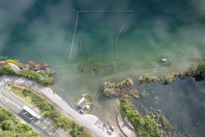 Lake Rotomā has flooded playgrounds and boat ramps. Photo / Andrew Warner.
The same is true at Lake Ōkataina, where pā sites lay submerged, he says.
'It is also one of the reasons why, as iwi, historically we haven't chosen to live close to those lakes.”
Iwi knew it was unsafe to build major infrastructure close to the lakes and, going forward, he believes it will influence rules around the proximity of homes to the water.
Toi Moana Bay of Plenty Regional Council lakes operations manager Andy Bruere says while a number of people have suggested underwater outlets at both lakes should be cleared, the council will not do that.
The locations of the outlets are not easy to find and are under many metres of water.
Each outlet is unlikely to be capable of causing a significant drop in water levels and if any are, work on those outlets can have uncertain effects.
It is not possible under the law to work on the lake bed, he says.
'If we wanted to do work to unblock the possible outlets we would first need to research the impact of doing so and make application for resource consent, taking account of all the necessary effects and mitigations.
'In time, the lake levels will reduce. If we tamper with the possible outlets sometime in the future, we could be dealing with extremely low lake levels because we have damaged the outflow.”
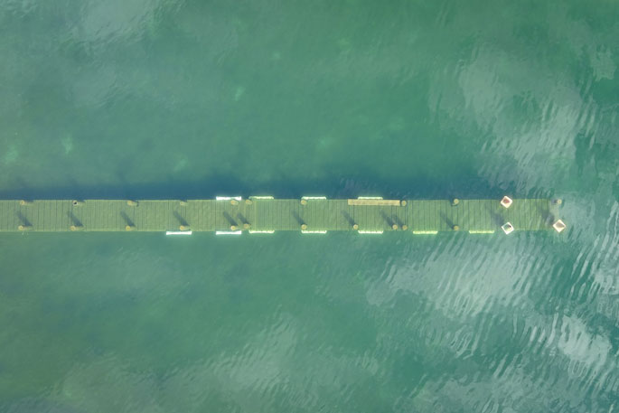
The point where Lake Rotomā can overflow is a natural saddle.
 Infrastructure and facilities at Lake Rotomā are underwater. Photo / Andrew Warner.
An overflow structure was built in the 1970s that collects possible overflow water into a sump, eventually making its way to Rotoehu through a natural valley.
Bruere says the structure will help water flow safely into the valley, but the implications are that while Rotomā will stop rising with rainfall, Rotoehu could rise faster.
He says water has never reached the structure before and there is no certainty it will reach it now. It is currently 450mm away.
'Because we have no experience with it overflowing before, any predictions on its overflow are simply speculation. As the lake level rises it occupies a larger area and finds additional seepage pathways to release water.
'Time will tell if it overflows.”
Bruere says winter is known for higher rainfall and storm events and so the council acknowledges growing uncertainty and is helping where it can.
'We acknowledge the impact and stress this will be causing our communities, in particular our Rotomā and Rotoehu whānau.”
Working groups established
Two groups have been set up to mitigate the issues, one focused on finding short-term solutions, the other long-term.
Rotorua Lakes Council leads the Rotoehu-Rotomā Response Team, a joint-agency team that includes Bay of Plenty Regional Council, Te Arawa Lakes Trust, local iwi and Waka Kotahi.
It has three main focuses: Co-ordinating the response to requests for help from impacted residents, such as requests for sandbags or rates relief; providing a ‘single point of contact' for residents and property owners in Rotoehu and Rotomā; and maintaining an overview of day-to-day impacts and operational matters.
Calls are made to the council, are triaged and callers are linked to the appropriate service or agency.
The Te Arawa Lakes Strategy Group established a group to scope foreseeable climate change effects on lake levels to explore a range of possible interventions/approaches and based on a set of criteria including cost/benefit analysis develop adaptation and mitigation options for the Te Arawa lakes communities.
This group comprises representatives from the lakes programme partners Te Arawa Lakes Trust, Rotorua Lakes Council and Bay of Plenty Regional Council, plus regional leads for Crown agencies such as Waka Kotahi and representatives from local iwi groups.
The scope and terms of reference for this working group will be reported to the Strategy Group in September and its ongoing progress reported regularly.
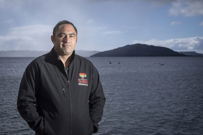 Arapeta Tahana stands at Lake Rotorua. Photo / Andrew Warner.
Tahana says the working group's general focus is on the wider Rotorua district as well as the situation at Rotoehua-Rotomā.
Solutions needed to be weighed up with what is affordable, particularly around roading, where sections are already being eroded and damaged.
'Does there have to be an alternative altogether?”
Tahana says it will be a collective, joint agency effort to address these issues.
Rotorua Lakes Council infrastructure and environmental solutions deputy chief executive Stavros Michael says the response team acknowledges the impact and stress of impacted residents and their safety is its priority.
As of last Wednesday, it has received 15 calls for help, including people seeking rates relief, requests for sandbags and road closure information.
Manawahe Rd and Pongakawa Valley Rd between Kennedy Bay and Soda Springs have been closed to traffic.
'We understand there may be frustration around road closures but ask that everyone respect the barriers that are in place to protect our communities and not attempt to move them, which we are aware has happened.”
The council is watching lake levels closely and helping where it can.
The record rainfall creates challenges such as inundation of homes, land, roads and network infrastructure, as well as significant erosion.
But lake water inundation is not the same as river flooding, which tends to recede quickly.
'With lake levels rising over time and not receding, property inundation may happen over time and even when the waters eventually recede, the ground may be compromised.”
 There has been no beach at Blue Lake, Tikitapu, for months. Photo / Andrew Warner.
Issues from persistent high lake levels ranged from erosion, raised groundwater levels as well as undermined embankments and road foundations.
High groundwater implications include water going into the wastewater network making effective treatment challenging and impacting disposal costs, as well as causing issues with building foundations and septic tanks
Roading woes
State Highway 30 is the main route to Kawerau and Whakatāne from Rotorua and water has reached the road edge, like near Allan's Rotomā garage.
Waka Kotahi Waikato system manager Cara Lauder says it is working with both the Rotorua and Whakatāne district councils to monitor and manage the flooding issues on the highway.
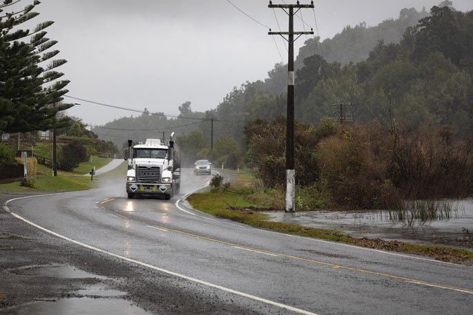 Lake water is nearly at the roadside along State Highway 30. Photo / Andrew Warner.
Lauder says it is one of many sections of highway facing challenges and resilience for the network is essential for safe and reliable connections to communities.
'However, the current high lake water level will fluctuate and it is highly likely to recede in the near future.The high level also happened about 50 years ago, so it can be expected to happen occasionally.”
For now, Lauder says a short-term resilience improvement for SH30 is underway, with rock armouring to the lakeside bank.
Surveys show in most sections of the highway, one lane will be available past Lake Rotomā even at maximum lake levels.
Due to the pumice subgrade, the road surface can handle being underwater for long periods without too much damage.
'If we hold any concerns about the safety of road users, the highway will be closed and traffic diverted.”
With some driveways already below lake level and access impacted, options for pumping were being investigated.
'Waka Kotahi will continue to work hard with property owners to ensure that access from SH30 is managed as effectively as possible. Our priority is public safety and access.”
- Public Interest Journalism funded through NZ on Air

2 comments
Dont worry they'll run out
Posted on 10-07-2023 12:33 | By an_alias
It will be no problem, the council is in charge, lets face it even in our record rainfall year they put restrictions on usage. They are that good and managing
Hmmm
Posted on 10-07-2023 15:14 | By Let's get real
Will paying people to talk result in less rain...? There's a story about a King who believed that he was so powerful that he could stop the tide coming in... Same results guaranteed.
Leave a Comment
You must be logged in to make a comment.