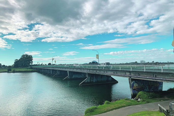
Whakatāne District Council has asked staff to prepare a business plan for a new bridge across the Whakatāne River that can be used to tout for funding.
A report to the infrastructure and planning committee meeting this week, set the scene for discussion about potential ways forward for a second bridge for Whakatāne township.
The report, which summarised relevant investigations done in the past 40-plus years, was requested by Mayor Victor Luca, who has been a strong advocate for another bridge.
Dr Luca says there are various reasons he would like to see another bridge built, but most importantly, the devastation Cyclone Gabrielle wreaked on the East Coast earlier this year has been an eye opener for many about the need to strengthen roads and bridges.
“We do need to improve the resilience of our roading networks, our communication networks and other considerations.”
He says a second bridge can't be funded by rates but will require central government funding, something he has discussed with both East Coast MP Kiri Allan and National party transport spokesman Simeon Brown.
Allan had told him it's not the cost of the bridge that's problematic, but approach roads and land acquisitions associated with it.
Brown told him a good business plan or proposal was a necessity if the council hoped to gain any outside funding for such a project.
Dr Luca moved that the committee request staff develop options for a proposal for another river crossing for the town. The committee voted to accept the motion.
“The idea here is to have a proposal together so we can go around and hustle for money. It’s not intended that this will be whacked on to our long-term plan, because we don’t have the money.”
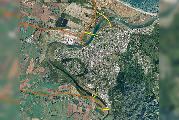 Four bridge options were investigated in 2018, including between McGarvey and Keepa roads, Peace Street and Keepa Road, Rewatu and Arawa roads and Rewatu and Valley roads. The two Keepa Road options have since been declared unfeasible due to the boat harbour development taking place there. Image Whakatāne District Council.
Several studies have been carried out since the 1980s that relate to the Whakatāne Bridge, either directly or indirectly.
1980: A Whakatāne Traffic Study projected a second bridge may be required once the town population reached 17,000. A proposed crossing point was from McAlister Street to Bunyan Road, with an estimated cost at the time of $14 million.
1995: A further study into this proposal noted that while the base cost of the proposed bridge was $14 million, the actual cost, taking into account the cost to repay loans, was closer to $45 million. It was decided the cost was too great to include in that 10-year-planning process.
1996: A Whakatāne River Bridge Study investigated the capacity of the current bridge to accommodate future traffic flows and found intersection upgrades should be considered to ensure the bridge could be used to its full capacity, assessed to be between 20,000 and 25,000 vehicles a day.
2004: A report on the Landing Road roundabout proposed three options to ease congestion – a double-laned roundabout, a slip lane onto Landing Road and replacing the roundabout with traffic lights. Each option had a cost estimate of about $2 million.
2007-2008: Whakatāne Township Network Investigations recommended the existing bridge be widened to four lanes by 2016. A joint report by the council and Transit NZ identified a bridge option to the south of town in the vicinity of the current water treatment plant. Estimated costs without associated roading were $10 million.
2016 - The teardrop configuration of the Landing Road-Hinemoa Street roundabout came into force, stopping right-turns from Hinemoa Street to Landing Road. While this was successful at cutting travel time for people coming into town across the bridge during peak morning traffic by about three to five minutes, and has stayed in effect until now, it has created new problems by moving arterial traffic into residential streets and severing the arterial ring route.
2018 - Four bridge options were investigated at a high level for cost and feasibility: McGarvey Road to Keepa Road; Peace Street to Keepa Road; Rewatu Road to Arawa Road and Rewatu Road to Valley Road. Due to the boat harbour development, the first two options are no longer feasible. The 2018 cost of the remaining two options was estimated to be $26 million for the bridge without any associated connections or land purchases for approaches.
2020: An Active Whakatāne Strategy was adopted that identified the Whakatāne River bridge as part of its vision for a long-term connected network of walking and cycling paths.
Present: The Eastern Bay Spatial Plan, currently under development, is intended to identify areas for new growth and infrastructure required to support it. Research commissioned as part of the plan indicates an additional 1560 dwellings will be required in the district by 2033, placing significant strain on the town’s arterial network and bridge. However, bridge capacity has been revised from the 1996 figures to 25,000 to 30,000 vehicles a day.
Public Interest Journalism funded through NZ On Air.
![]()

0 comments
Leave a Comment
You must be logged in to make a comment.