“Blue means go” is one of the main differences people enjoying the Bay of Plenty coast will notice in the updated tsunami evacuation maps this summer. There is also a new QR code to help direct people.
The Bay of Plenty Civil Defence Emergency Management Group has updated the region’s tsunami evacuation maps to be consistent across all councils and are also updating tsunami sign boards and waterways from today.
Some of the zone boundaries have changed, including parts of Opōtiki, Whakatāne and Pāpāmoa East.
“The main difference is that we have stopped using red, orange, and yellow for evacuation zones. Our updated maps have a single blue evacuation zone,” says a BOPCDEM spokesperson.
Some evacuation zone boundaries have been changed as part of the update. In most cases these are minor, but a few locations have more significant changes.
“We have made it easier to find out if people are in a tsunami evacuation zone: people can scan a QR code for ‘you are here’ information.
People are being asked to check their updated maps so they are familiar with any changes before heading to the coast this summer.
“Families of the Bay of Plenty need to know what to do and where to go to keep safe in an emergency and for those who live, learn, work and play along our Bay of Plenty coastline, knowing what to do and where to go is key,” says Bay of Plenty Civil Defence Emergency Management Group chair Mayor Faylene Tunui.
“People of the Bay of Plenty have let us know that the tsunami maps needed to be simple, easy to understand and the same across our region so that’s what’s been done – the same consistent messaging for the one same shoreline’."
 Chair of the Bay of Plenty CDEM Group is Kawerau Mayor Faylene Tunui. Photo: Supplied.
The mayor says progress in tsunami science means future regional evacuation maps will have more detailed information.
“Our Emergency Management Bay of Plenty team keep up to date with all the latest science, technology, data and modelling and are committed to keeping those of us who call the Bay of Plenty home as informed as we can.
“Reviewing the way in which we communicate with and inform our people, such as with tsunami evacuation maps, is one of the ways we can ‘get ready’ to keep safe’.”
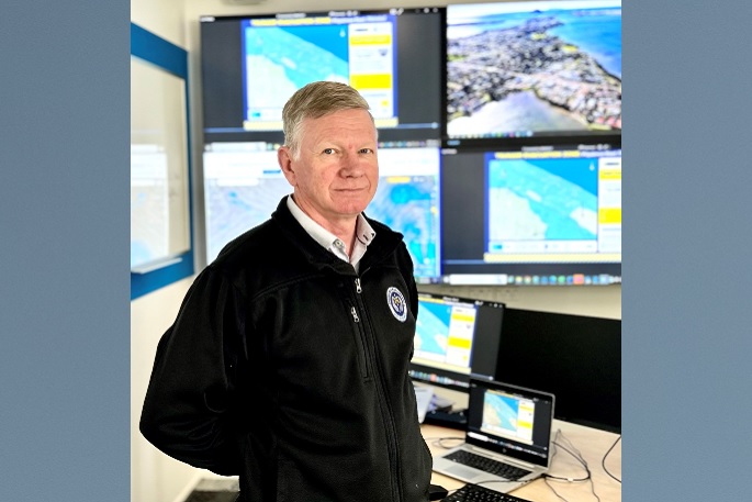 Bay of Plenty Emergency Management director Clinton Naude. Photo: Supplied.
Clinton Naude is director of Emergency Management Bay of Plenty. He says if there is a potential tsunami, his team advises people in all evacuation zones to move inland or to higher ground.
“With tsunami, we could be dealing with very short timeframes, so we wanted to make sure people had clear guidance on whether they would need to stay or go.
“With our updated maps, it’s easy to remember ‘blue means go’. We are telling people to get out of the blue if there is a potential tsunami.”
Clinton says in most cases the boundaries of the tsunami evacuation zone - the blue zone - will be the same on the updated maps. But for region-wide consistency, some evacuation zone boundaries have changed, so people should have a good look at their updated local map.
New QR Code – ‘You are here’
There is also a new QR code that people can scan for ‘you are here’ imagery and other tsunami information.
.jpg)
“People who live in coastal areas are pretty clued up on what to do in a tsunami, but from time to time there will be changes because we always need to make sure we are supporting our communities as well as we can.
“That’s why everyone should check the QR code or the online maps to see if they live, work or play in the blue tsunami evacuation zone. For some locations, the zone boundaries have changed. This includes parts of Opōtiki, Whakatāne and Pāpāmoa East.”
Clinton says the general advice for what to do in a tsunami hasn’t changed.
“Know your zone, have a plan of where to go and how to get there, and have a bag of essentials ready to go.”
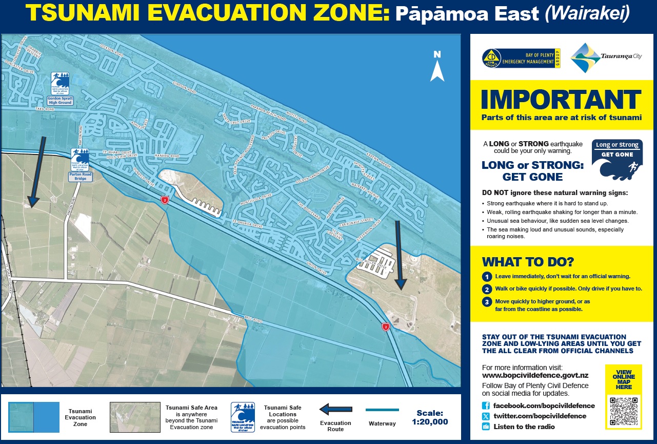 Papamoa East has tsunami safe areas marked on the coastal side of the Tauranga Eastern Link/State Highway 2. The blue area reflects where water is likely to reach during a tsunami. 'Right' click and choose 'open image in a new tab' to see enlarged version.
Faylene says progress in tsunami science means future regional evacuation maps will have more detailed information.
“We need to stay across the latest science with tsunami, just like we do with things like geotech and flood risks,” says Faylene.
“When new data and modelling for our region is available, we will make sure our tsunami evacuation maps reflect that. That won’t be for a couple of years yet- but watch this space!”
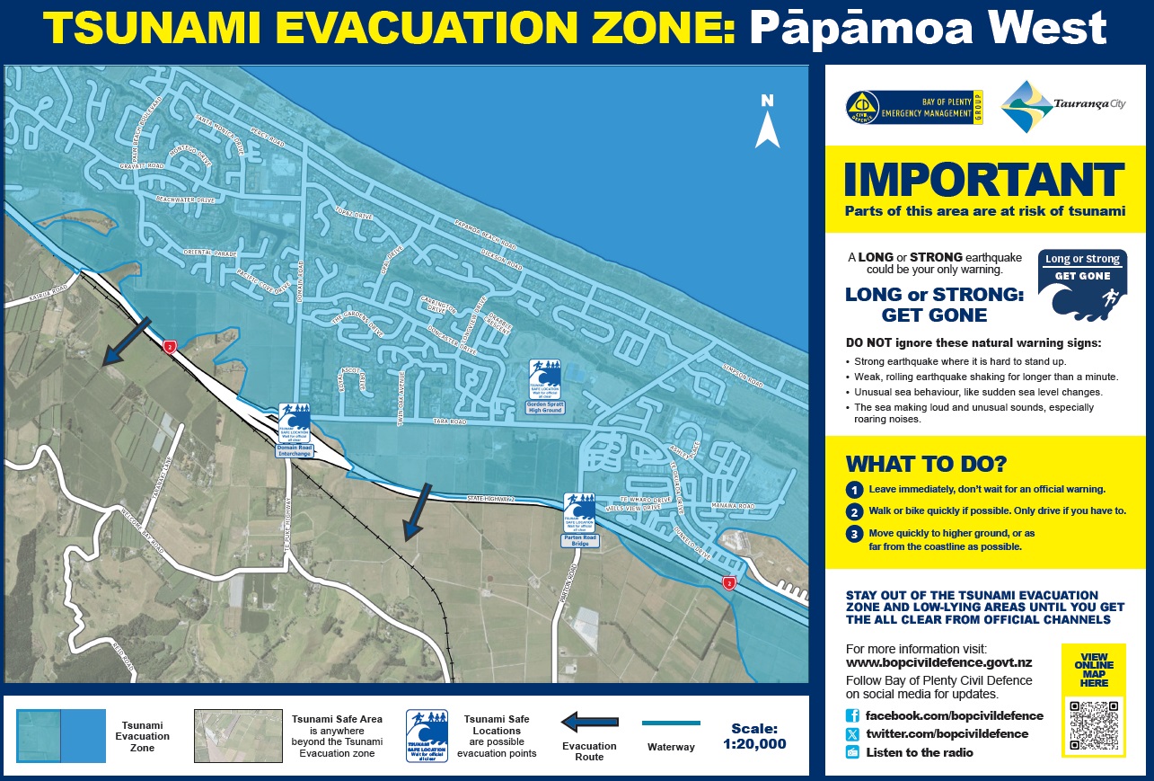 People living in Papamoa West will mostly need to cross the Tauranga Eastern Link/State Highway 2 to reach tsunami safe areas.The blue area reflects where water is likely to reach during a tsunami.'Right' click and choose 'open image in a new tab' to see enlarged version.
Bay of Plenty is not the only region to adopt the colour blue for the tsunami evacuation zone. Waikato Civil Defence Emergency Management Group also has a ‘blue zone’ on its maps, and in Wellington, there are blue lines on roads to show tsunami evacuation safe zones.
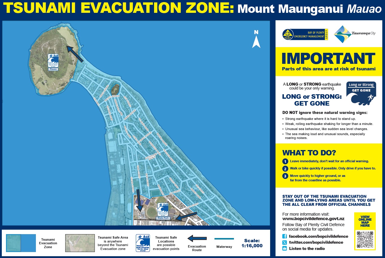 Mauao, Mount Drury and Blake Park are the tsunami safe zones at Mount Maunganui. The blue area reflects where water is likely to reach during a tsunami.'Right' click and choose 'open image in a new tab' to see enlarged version.
Important general tsunami information for Bay of Plenty
The national guidance ‘Long or Strong, Get Gone’ remains a core of our region’s tsunami readiness.
This is because the biggest risk to Bay of Plenty from tsunami would be a major local or regional undersea activity that could trigger a significant tsunami and give us little time to prepare.
Long or Strong = a quake that is either longer than a minute or strong enough that it is hard to stand.
Get Gone = leave immediately if you are in a tsunami evacuation zone. Head inland or to higher ground. Stay there until you get an official all-clear.
If you are not in a tsunami evacuation zone and you are safe where you are, stay put and stay off the roads.
Bay of Plenty has two significant subduction zones - active undersea areas - relatively close to us. These are the Hikurangi Subduction zone (East) and the Kermadec Trench (North-east). Major activity in either of these areas could cause tsunami on our coastline.
Activity further away, in other parts of the pacific ‘ring of fire’, could also cause tsunami here, but these would give us more warning, and scientists would be able to monitor the so we knew more about what to expect. An example of these ‘distant source’ tsunami is from an undersea quake off the coast of Chile.
Tsunami is a low probability but high-risk hazard for Bay of Plenty. What that means is that although large tsunami rare, they would be a significant threat to life and property. Fatal tsunami activity has been recorded in New Zealand during the relatively brief period that people have lived here, and our coastline is far more densely populated these days.
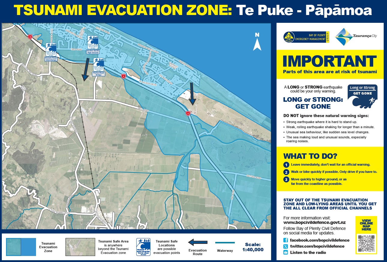 The Te Puke-Papamoa map shows the tsunami evacuation zone and safe areas. 'Right' click and choose 'open image in a new tab' to see enlarged version.
How Civil Defence Emergency Management works in Bay of Plenty
The Bay of Plenty Civil Defence Emergency Management (CDEM) Group is comprised of all seven councils in Bay of Plenty: Opōtiki District Council, Kawerau District Council, Whakatāne District Council, Rotorua Lakes Council, Western Bay of Plenty District Council, Tauranga City Council and Bay of Plenty Regional Council.
The Bay of Plenty CDEM Group is governed by a committee of mayors, commissioners and appointed councillors representing each of the Group’s councils. The chair of the Bay of Plenty CDEM Group is Mayor Faylene Tunui (Kawerau) and Deputy Chair is Mayor James Denyer (Western Bay of Plenty).
The Bay of Plenty CDEM Group office is called Emergency Management Bay of Plenty (EM BOP). EM BOP has a team of fulltime professional emergency managers whose work supports CDEM across the region in line with decisions made by the Bay of Plenty CDEM Group. Clinton Naude is director of EM BOP.
Individual councils also have professional emergency management staff whose work supports communities in their own jurisdictions in line with Bay of Plenty CDEM Group directions.
These emergency management staff from councils and EM BOP also serve as specialist responders during emergency events. When a larger response is needed, their numbers are bolstered by CDEM-trained staff from within Group councils whose normal jobs are in other roles.
Beyond councils, marae, schools, health providers, community groups (and more) have their own emergency plans and activities designed to meet their specific needs. Local and regional emergency management teams give them support, information and guidance to lead this work themselves.
At the individual and whanau level, everyone has a role in Civil Defence Emergency Management by making sure they know the hazards for the places they live, work and play, by having a plan for what they will do if an emergency hits, and by making sure they have basic emergency supplies at home and a ‘grab and go’ bag of essentials in case they need to evacuate.
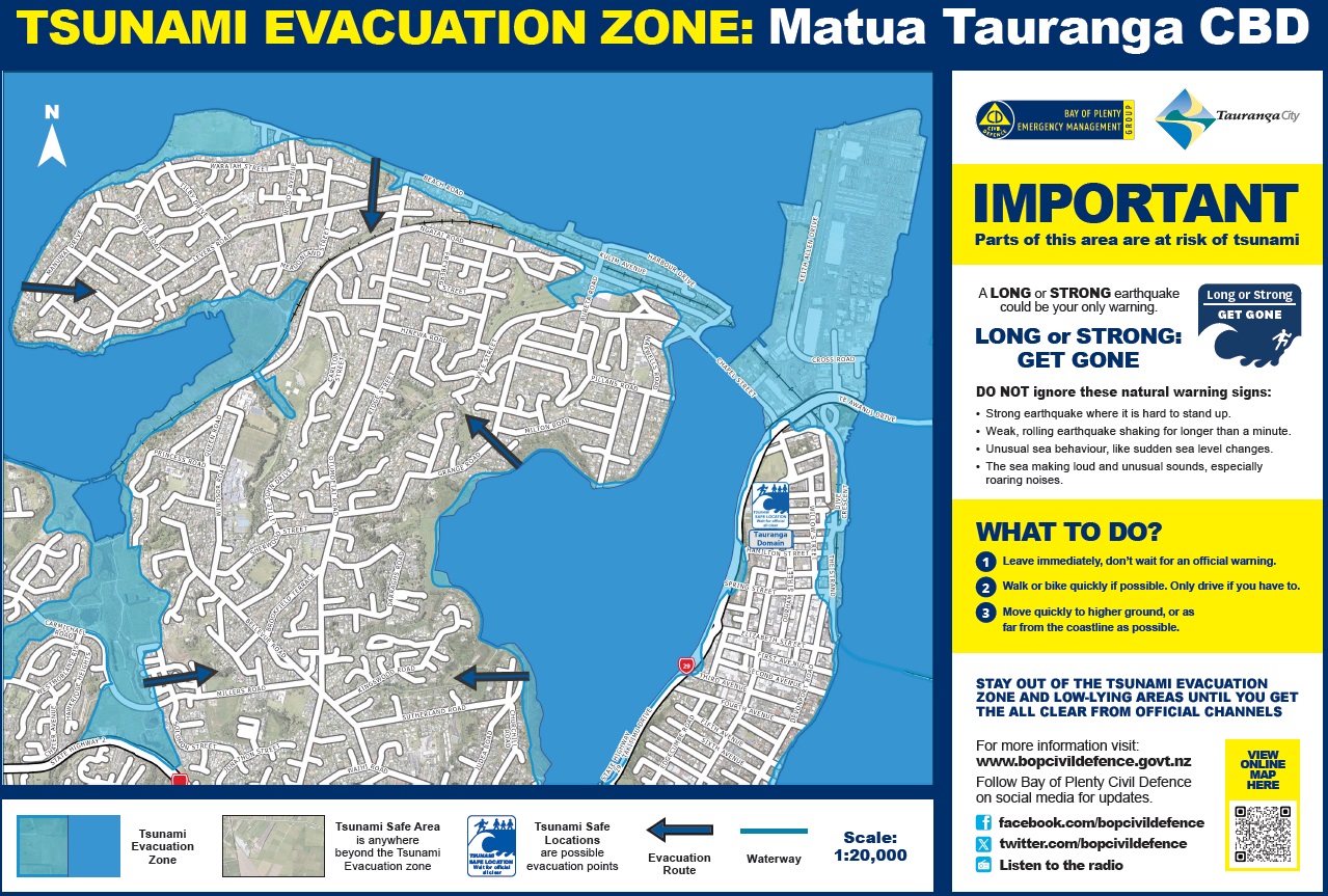 Maps for Tauranga harbour also show tsunami evacuation zones and safe areas. Blue shows where water levels are likely to reach.'Right' click and choose 'open image in a new tab' to see enlarged version.
For all regional tsunami maps go to www.bopcivildefence.govt.nz
Local maps are also on relevant council websites.
Bay of Plenty tsunami evacuation maps are part of the national tsunami map site www.civildefence.govt.nz/get-ready/get-tsunami-ready/tsunami-evacuation-zones/
Tsunami sign boards at beaches and waterways will be updated from today and over the next few weeks.

0 comments
Leave a Comment
You must be logged in to make a comment.