February is upon us and the final offical month of summer still has plenty of hot days - but there's a lot of low pressure in the mix, says WeatherWatch.
Many of us imagine February as the hottest, most settled, month of the year - but NZ's location on earth (halfway between the equator and Antarctica and partially in the Roaring Forties) means every single year is different...and it's all down to the lay of air pressure at the time.
"There is a remarkable lack of high pressure in the coming weeks for our side of the planet," says a spokesperson for the weather organisation.
"Not to say we don't have high pressure sticking over NZ at times, but when you zoom out there isn't as much high pressure as you'd normally think for the 'main' part of summer around NZ, Australia and the South-West Pacific region.
"The El Niño we have right now means windier westerlies are more likely in NZ - and we've certainly had that over summer in the South Island - but the increase in low pressure around us means it won't always be a westerly, with easterlies continuing to brush northern NZ due to so much low pressure in the tropics."
You could argue the tropics look more like La Niña than El Niño right now - both atmospherically and marine-wise, says WeatherWatch.
"El Niño is still with us officially - but the sea surface temperatures in the Tasman Sea and north of NZ in the tropics is anything but El Niño. It has a strong La Niña look to it. Our local sea surface conditions are normal according to the Moana Project.
"Also, the Tongan underwater eruption two years ago may also be partially to blame, with some studies suggesting it's warmed the planet by 0.5c.
"If so, that would definitely increase the chance of rainy areas. It's possible El Niño weather in our part of the world has been complicated by this eruption - and the marine heatwaves - and it's all combining to make our weather go one step forwards and one step backwards.
"It might explain why so many people across NZ and Australia are saying it doesn't feel worse than a "normal summer" despite a strong El Niño at play (and yes, it very much is still officially here even if you don't have the EN weather pattern at your place).
"Long range data - and the lack of high pressure - suggests rainmakers will continue around NZ and Australia for the rest of summer - but some stubborn narrow areas of high pressure are still in the mix, especially from Perth to Adelaide to Melbourne - and then potentially on to NZ.
"Think of NZ as a double bed and the incoming highs are single duvets only. So not everyone will get coverage - and that allows for changeable weather around the edges."
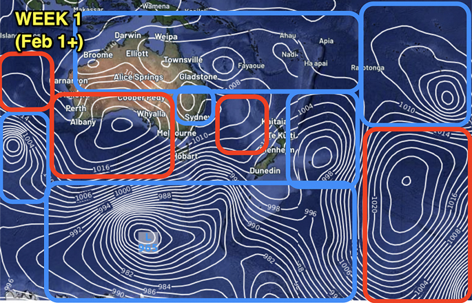
WEEK 1 - February is kicking off with a big storm in the Southern Ocean, and the nearest protective high pressure to NZ is far to the west over the Great Australian Bight. As we go into Feb 2 and Feb 3 this storm will send an Autumnal gale westerly over NZ. For some it may feel like summer has ended with gales and cooler weather... but it's gone by Sunday as a narrow ridge of high pressure from Australia moves back in. But it shows how very unsettled the weather pattern is around our side of the world this month.
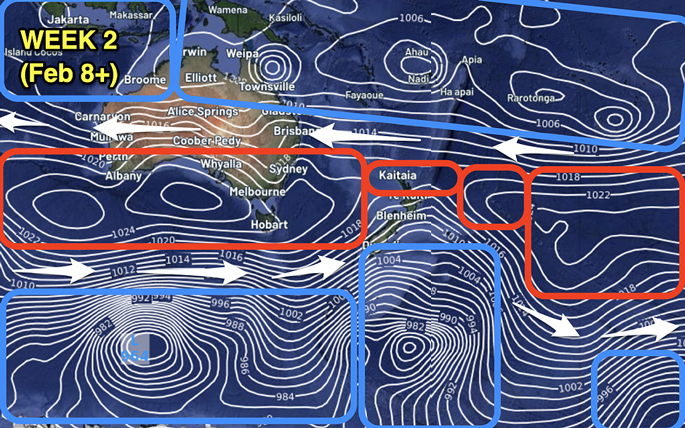
WEEK 2 - Some order to the chaos. That thin belt of high pressure remains parked along the southern side of Australia and sends a narrow ridge over parts of northern NZ. Elsewhere this encourages a windy westerly which, as many of you know, makes eastern areas hotter and drier. Last year we said one of the concerns about El Niño was that it could drive in a much hotter and drier end to the summer season and start to Autumn for those in the east.

WEEK 3 - The belt of narrow high pressure continues to track along southern Australia and into the NZ area. But the belt of low pressure in the Tropics can't be ignored with so many low pressure centres (at least 5 or 6) and the potential for a tropical cyclone is there with any of those lows (especially the low near Western Australia - but this far out that could still easily change). Either way, this shows the tropics is FAR MORE ACTIVE than it normally would be in an El Niño summer, and it also adds a "wild card" factor to the forecast, in the sense that surprise rain events are possible for both NZ and Australia. Farmers mostly LOVE this... those harvesting or on holiday often do not!
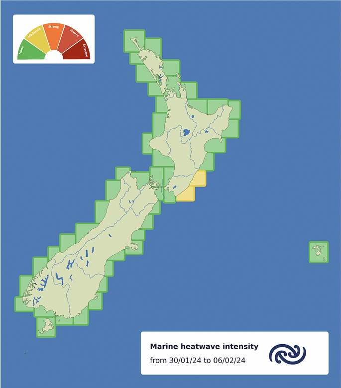
Despite the marine heatwaves across the Tasman Sea and South Pacific north of NZ, NZ itself is about where we should be - according to the Moana Project.
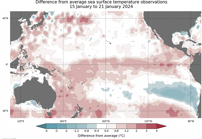
El Nino is fading at the equator over towards South America, but sea surface temperatures there are still 3 to 4 degrees above normal. Normally this set-up means the Tasman Sea, Coral Sea and north of NZ is cooler or normal.... not this year. This year these areas are 2 to 3 degrees above normal...which is certainly complicating the weather around NZ and Australia and encourages more "localised" areas of rain - which is what we've seen this summer so far. Credit: BoM.

From BoM: The model of all models shows all international modelling agrees that El Nino is either gone, or mostly gone, by the time winter starts.
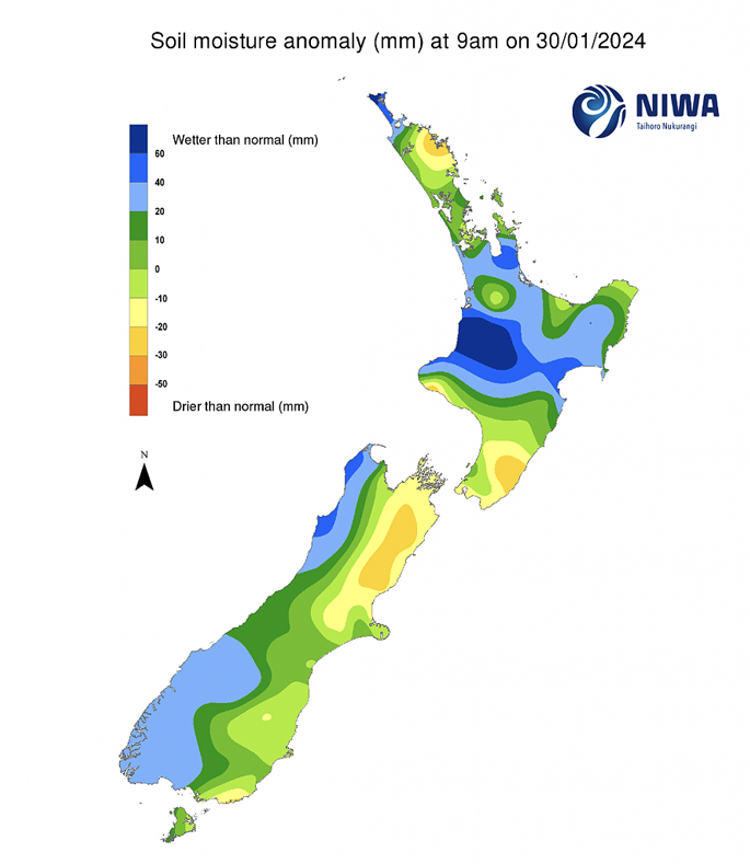
Current soil moisture levels aren't concerning for most regions, but certainly parts of Canterbury, Marlborough, Wellington and Wairarapa are all quite dry. The upcoming weather pattern suggests dry areas will get drier due to more westerlies and more high pressure. But the rain and thunderstorms of previous weeks have given most other regions a positive boost going into this month. Map funded thanks to the NZ Taxpayer. Niwa is a Government Agency 100% owned by the NZ public (not that you'd know it).

Upcoming rain for the Australasia Region shows high pressure is very stubborn over southern Australia and that somewhat stretches out to parts of NZ. Places like Adelaide may receive no rain at all for the next 15 days. The tropics shows heavy rain across most of the island nations.

Upcoming rainfall for the first half of February and a closer look at NZ shows heavy West Coast rain on the way (mostly in the first few days of Feb thanks to that storm in the Southern Ocean), but many northern and eastern areas are much drier. Canterbury to Marlborough to Wellington and Wairarapa may be the most likely area to dry out in the coming weeks.


0 comments
Leave a Comment
You must be logged in to make a comment.