The regional council is about to have another go at the Kaituna River mouth, altering the river so part of the flow goes through the Maketu estuary to the sea.
The committee adopted an engineer's report presented to the Operations Monitoring and Regulations Committee, recommending the ‘maximum flow, partial diversion' which is option two in a report by consulting engineer Steve Everitt.
It is considered the option that maximises ecological and cultural outcomes while minimising cost and consenting risks.
The lower Kaituna River has been significantly altered during the last century mainly to reduce the level of flood risk to adjacent lands. The alterations created negative ecological and cultural consequences.
Major physical works undertaken since 1900 have collectively reduced the flood-risk to surrounding property, but negative ecological and cultural effects include in-filling of the estuary, loss of kai moana, and reduction in habitat for native plants and animals.
The Kaituna River and Ongatoro/Maketu Estuary Strategy sought to address some of these negative effects and it specifically contains a goal to re-divert water from the Kaituna River back into the estuary. Council is committed to implementing this strategy.
These effects have resulted in calls from the Maketu community for the Kaituna River to be re-diverted back into the Ongatoro/Maketu Estuary. The regional council is a partner to and major player in the development and implementation of the strategy.
The strategy is to ensure there is an improvement in the sustainable management of the river and estuary resources by 2018.
On July 14 this year, staff took a small step toward restoring the Maketu Estuary by allowing tidal flows back into the western end of the Papahikahawai channel by excavating 80m3 of sand from the Maketu Spit. Water quality is monitored weekly.
In two weeks there was a substantial reduction in sheets of algae which have dominated the channel west of the causeway for a long time. Water quality is expected to continue to increase over time, along with improved and enlarged habitat for whitebait and other indigenous biodiversity.
The regional council has allocated $486,498 in 2012/13 and 2013/14, and $736,498 in 2014/15 within the Sustainable Coastal Implementation Programme and committed to, among other things investigate re-diversion of water from the Kaituna River into Ongatoro/Maketu Estuary.
The council also allocated $180,000 - $300,000 in 2015/16 and 2016/17, plus capital expenditure of $2,288,000 in 2015/16 and $1,775,000 in 2016/17 and committed to, among other things; carrying out works to re-divert water from the Kaituna River into Ongatoro/Maketu Estuary (subject to resource consent).
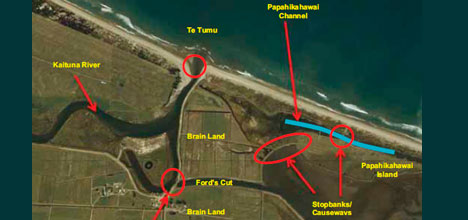
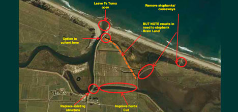
The ‘maximum flow partial diversion' option is expected to deliver an average of about 600,000m3, 21 per cent of the Kaituna River flow to the estuary during each tidal cycle via Ford's Cut and Papahikahawai Channels – a 400 per cent increase on the current flow from the river to the estuary.
This option is not expected to increase flood risk to low-lying properties and is expected to retain sufficient flows at Te Tumu for boating.
A one way flow from the river to the estuary will be maintained by the use of flapgates or gates on culverts or bridges. As the tide falls in the river, water is prevented from flowing from the estuary back to the river and out the Te Tumu Cut.
Reopening the Ford's Cut river loop could also be considered as a refinement to increase freshwater flows into the estuary.
Anticipated cost of the works involved is $3-4 million, which matches the allocation in the Ten Year Plan 2012-22. It's considered the best outcome as far as money spent and ecological outcomes go, and it doesn't close off options to re-divert more river water through the estuary in future.
The regional council will also shortly make a formal approach to the Minister of Conservation for agreement from the Crown that it will apply for renewal of its current re-diversion consent, and lead and fund future re-diversion work.
Regional council staff are working with local farmer Allan Brain, who farms land some 700m west of the causeway, and has concerns that reopening the channel will adversely affect his land and farming.
Timeline of Te Tumu tinkering:
1880's Crown made swamp land in lower Kaituna available for European settlement expecting land to be drained and turned into production.
1895 Te Puke Land Drainage District constituted under the Land Drainage Act 1893.
1906 Tumu-Kaituna Drainage District constituted. Draining of wetlands.
1907 River broke out naturally at Te Tumu – no flow through Estuary.
1907-1951 Significant flooding, most serious in 1951.
1926 Kaituna River District Board made two parallel cuts through Crown Land leased at the time by Mr Ford (known as Ford's cut or twin cut) to divert water directly back into the estuary. By this time the Kaituna River had returned naturally to the estuary via the Papahikahawai channel.
1926-1956 All Kaituna river flow to the estuary through the Paphikahawai and Fords cut
1951 Following further flooding, investigations undertaken and a report was prepared which suggested the Kaituna be re-diverted through Te Tumu to the ocean.
1954 Kaituna River Board approved diversion of the Kaituna away from Maket Estuary 1956 Te Tumu Diversion to sea. Ford's Cut & Papahikahawai blocked. This diversion was intended to reduce flooding on surrounding land
1956-1995 All river flows were out through Te Tumu apart from seepage through Fords cut or flow over the ford into Fords cut during floods.
1979 Start of Kaituna Catchment Control Scheme. Kaituna River Diversion was constructed to bypass River loop.
1984 Parliamentary petition to get water re-diverted back to the Estuary
1989 Maket Estuary Restorations Strategy produced by DOC in response to a Cabinet
paper. Specific actions in Strategy.
1990 DOC applies for consent to divert water into estuary in partial re-diversion. Applies
for 400,000 cumec per tidal cycle. Only granted 100,000 cumec per tidal cycle due
to water quality constraints
1992 – 1996 Various appeals against consent decision, to Planning Tribunal and High
Court. Last of appeals finally resolved and re-diversion implemented (1996).
2001-2002 Options to re-divert greater quantities of Kaituna River flow through Estuary identified and considered by Maketu Estuary Focus Group
2005 BOPRC Strategic Policy Committee directed staff to develop a Kaituna River and
Maketu Estuary Strategy and form a Joint Governance Committee in accordance with LGA.
2006 Community consultation through various working parties, focus groups, iwi and hapu, community groups and government organisations to identify issues for inclusion in strategy.
2007 Construction of Ohau diversion wall is perceived as creating poorer river water quality through increased nutrient loads – however this is shown to be insignificant.
2008 Culmination of community consultation started in 2006 is completion of Draft Kaituna River and Ongatoro/Maketu Estuary Strategy and its release for public consultation (November 2008-February 2009)
2009 Kaituna River and Ongatoro/Maketu Estuary Strategy is finalised – August 2009.
2009-2011 Water Quality modelling of full re-diversion undertaken, wetland feasibility study completed, conceptual vision of future Kaituna River and Ongatoro/maketui Estuary developed. On-going riparian management Kaituna catchment
2011-2012 DOC and Fish & Game develop concept for expanded Kaituna Wetland (unpublished). Modelling of different re-diversion options undertaken and presented to Regional Council for funding in 2012-2022 TYP. Option Prefeasibility and Consentability report completed.
2012 Regional Council agrees to include funding for partial re-diversion in 2012-2022 TYP subject to pursuing Central Government funding during 2012/13. Funding to be revisited for 2013/14 Annual Plan.
2012 BOPRC staff re-open Papahikahawai channel to tidal flows from Maketu Estuary. Subject to legal challenge by Brain family.
2013 DOC re-diversion consent expires in May 2013.

5 comments
About Time - YAHOO!
Posted on 22-10-2012 10:49 | By SonnyJim
Finally someone has the nerve, brains and money to wash out the scummy headwaters. We all know the estuary will not be the same as it was, just look at the huge farm encroachments that killed off birdlife areas for the mighty dollar. Good on the council for getting on with it! Support them.
huh
Posted on 22-10-2012 17:58 | By Capt_Kaveman
"include in-filling of the estuary" this part of nature over time to fill the low lands look whats happend to Tga harbour since dredging
SAFE BOATING
Posted on 23-10-2012 09:02 | By mattanddel
This river mouth already has problems with low water volumes over summer.Often the channel goes along papamoa beach.I believe the rock wall needs to be extended to protect the channel from the swells to provide a safer river mouth before any water gets diverted.
Well done!
Posted on 23-10-2012 16:58 | By Adrian Muller
Good to see that the Regional Council and other agencies are prepared to listen, and act, on getting the Maketu estuary back (a bit) to what it was decades ago, when it was a wonderful source of kaimoana to the locals. Maybe one day the true meaning of "papahikahawai" might come back into existence: "the land from which to catch kahawai" where in the ancient past these amazing"trout of the sea" were able to swim up this channel within the Maketu estuary, and be caught bu the tangata whenua.
Maketu Estuary
Posted on 24-10-2012 11:21 | By marama
Safe boating has other options. The exit wasn't built for boating, it was to cater for farmers land flooding. What is missing from this history is the Parliamentary Commissioner for the Environment instructions about the restoration of the estuary.
Leave a Comment
You must be logged in to make a comment.