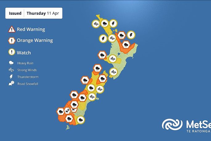
New Zealand is in the grips of a large weather system and multiple warnings are currently in place all over the country.
A heavy rain warning is in place for the Coromandel and Bay of Plenty.
In the Coromandel - locals and those heading away early for the school holidays should be especially careful tomorrow on the roads, says NZTA Waka Kotahi.
Heavy rain is expected from 3am until around 3pm on Friday – with a risk of thunderstorms. Surface flooding and slips are possible and could make driving conditions hazardous, warns the roading agency.
A severe thunderstorm watch is also in place for the Bay of Plenty which could produce localised downpours. Drivers should be prepared for 80 to 140 mm of rain in parts of the region, especially about and east of Rotorua.
"Drive to the conditions – watch following distances – and be prepared that there could be debris or pooling water on the road ahead.
"NZTA is monitoring the conditions closely, receiving regular updates from MetService and working with local authorities.
"Planned works around the Waikato and Bay of Plenty regions are weather dependent, and given the severity of forecast weather, will be deferred to the next suitable day if required. Our crews are proactively monitoring the state highway network and will be ready to respond if needed.
"As we head into the school holidays, expect to see more cars on the road. People are encouraged to keep a close eye on the weather forecast and plan ahead before starting any journeys throughout the region."
The NZTA Journey Planner contains the latest up to date road conditions, including any delays or road closures.
Heading into Friday, the MetService says this weather system also brings thunderstorms, strong winds, and snow over higher parts of the South Island before the end of the working week when the weather starts to settle.
 Image: MetService.
The western South Island is now in the second wave of heavy rain, which is expected for the bulk of Thursday.
An Orange Heavy Rain Warning remains until 3am Friday, with a further 150 to 200 mm of rain expected in the ranges south of Hokitika and lesser amounts near the coast.
The heaviest rain is forecast to ease late Thursday afternoon and evening, however showers and possible thunderstorms continue through into early Friday morning and periods of more intense rainfall are possible.
That is not the only area of concern. Southland, Tasman and inland Marlborough are also expected to be affected by heavy rain from this weather system as it passes through and are under Orange Heavy Rain Warnings until early Friday morning.
“Areas such as Southland and Clutha don’t need very large rainfall amounts to start seeing impacts from that rain, so we are keeping a close eye on developments there. Additionally, the top of the South Island will feel the compound effects of rain and northerly winds, and a Strong Wind Watch is in place there,” says MetService meteorologist Mmathapelo Makgabutlane.
The weather system will also make itself felt over the North Island.
Having started in Northland already this morning, wet weather is expected to move over the rest of the North Island on Thursday night into Friday, and Heavy Rain Watches and Orange Warnings are in place for areas most likely to be affected.
“Of particular concern will be thunderstorm activity, which may bring periods of more intense rainfall. A Severe Thunderstorm Watch is in place for Auckland, Northland, Coromandel, parts of Bay of Plenty and the Waikato where brief, localised surface flooding may be possible.
“Friday morning will likely be the wettest time, and it would be a good idea to factor that into commute plans.”
Stronger winds will also feature on Thursday and Friday across the country. Several Strong Wind Watches are in place, including over Auckland, Northland and the Coromandel Peninsula for strong northeasterly winds that may approach severe gale in exposed areas.
“The combination of very wet roads and gusty winds may make road travel extra challenging.”
Additionally, a rapid cooldown is expected Thursday night into Friday for the eastern and lower South Island, bringing snowfall to elevated areas of Otago and Canterbury above 600 metres.
 Snow is expected to fall in the South Island.
Road Snowfall Warnings have been issued for the Milford Road and the Crown Range Road, with a sharp temperature drop anticipated in eastern areas.
“This is an evolving system. For the latest updates and alerts, people are encouraged to monitor MetService's official channels and heed any directives from local authorities.
“As we move into the weekend, things start to settle down, a trend which continues into next week.”


3 comments
Speed Morons
Posted on 11-04-2024 13:09 | By Yadick
I have literally just come thru Katikati where the weather is closing in big time.
A 30kmh area, with workman, and the traffic is not slowing at all. Morons passing thru the site at a good 100kmh, trucks included, (normal road speed here is 80kmh.
Here's a thought to you moron speedsters, just perhaps these road workers would like to safely go home to their families tonight. SLOW THE . . . . DOWN.
yadick
Posted on 12-04-2024 12:27 | By hexsayer
then they shouldn't close off half of roads when they're not even working on them, leave slow speed/work ahead when there's no reason for that sign to be there. yesterday one of their work trucks was happy to just swing out into traffic on SH2 infront of cars some of which had to take evasive action while braking then drive along at 15-20km in the 30km zone while stopping every 10-20m for no reason. nah fudge em.
@ hexsayer
Posted on 12-04-2024 21:14 | By Yadick
I totally agree with your comment regarding roads not being worked. It is SO annoying.
If what you say is correct about the truck then they were definitely in the wrong but, without excuse, would've been an active site and stopping every 10 - 20mtr would surely have had just cause, however how you can say "nah fudge them" to someone's loved one not returning home outside of a casket beggars belief. What if that was your Mum, Dad, Son, Daughter, loved one . . . heart wrenching.
Leave a Comment
You must be logged in to make a comment.