
Heavy rain and possible heavy snow, along with northwest gales are being forecast for parts of central and southern New Zealand.
A severe weather watch for heavy rain is in place for the Bay of Plenty.
The MetService says an active front, preceded by strong northwesterlies, moves eastwards across New Zealand today, bringing heavy rain to western areas and possible heavy snow to 800 metres to Central Otago and the MacKenzie Basin.
"Warnings and watches for heavy rain, heavy snow, and strong winds are in place for much of the country," says an updated forecast from the weather organisation.
"People are advised to keep up to date with the latest forecasts in case further areas are added, or upgraded to warnings."
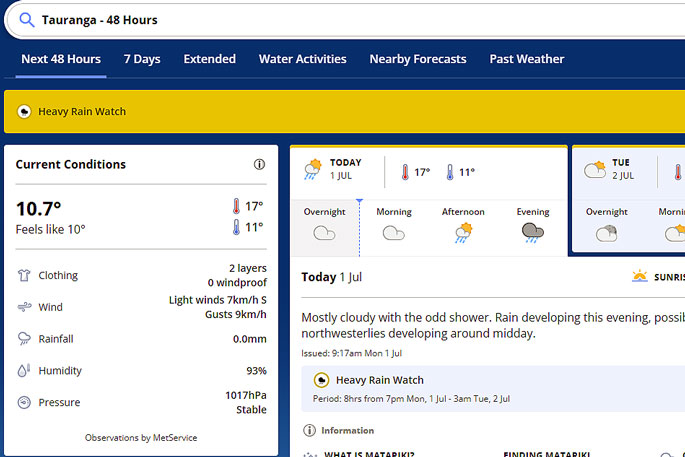 Image: MetService.
Heavy Rain Watch
Area: The eastern ranges of Bay of Plenty and the inland ranges of Gisborne
Period: 8 hours from 7pm Mon 1 Jul to 3am Tue 2 Jul
Forecast: A period of heavy rain, and amounts may approach warning criteria.
Low chance of upgrading to a Warning.
Area: The Tararua Range
Period: 7 hours from 12pm Mon 1 Jul to 7pm Mon 1 Jul
Forecast: A period of heavy rain, and amounts may approach warning criteria.
Low chance of upgrading to a Warning.
Area: Buller District, and Tasman west of Motueka
Period: 6 hours from 9am Mon 1 Jul to 3pm Mon 1 Jul
Forecast: A period of heavy rain, and amounts may approach warning criteria.
Low chance of upgrading to a Warning.
Heavy Snow Watch
Area: Central Otago northwest of Alexandra including the Queenstown Lakes, also the MacKenzie Basin
Period: 6 hours from 9am Mon 1 Jul to 3pm Mon 1 Jul
Forecast: A period of heavy snow above 800 metres, where snowfall amounts may approach warning criteria.
Low chance of upgrading to a Warning.
Strong Wind Watch
Area: Wairarapa south of Carterton
Period: 6 hours from 1pm Mon 1 Jul to 7pm Mon 1 Jul
Forecast: Northwest winds may approach severe gale in exposed places.
Low chance of upgrading to a Warning.
Area: Inland and northern parts of Marlborough
Period: 6 hours from 11am Mon 1 Jul to 5pm Mon 1 Jul
Forecast: Northwest winds may approach severe gale in exposed places.
Low chance of upgrading to a Warning.
Area: Canterbury High Country
Period: 4 hours from 9am Mon 1 Jul to 1pm Mon 1 Jul
Forecast: Northwest winds may approach severe gale in exposed places.
Low chance of upgrading to a Warning.

0 comments
Leave a Comment
You must be logged in to make a comment.