
Today is a fairly calm and dry day for many parts of NZ, ahead of more rain on Friday and potentially severe weather in the northeast of the North Island on Saturday.
Cloudy areas, fog and calm weather or light winds define Thursday - with wettest weather in the east from about Christchurch up to Napier, and then a few showers likely in Northland and the Far North by afternoon or evening, says WeatherWatch in its latest forecast.
“Friday sees rain returning to the north, and the western side of the country - along with a stronger north to northwest breeze to blow morning fog away and improve the weather in the east of both main islands, south of about Gisborne,” says a spokesperson for the weather organisation.
“It will again be warmer than average for most places.
“But from about noon Friday to 6pm Saturday a new low in the subtropics will rapidly deepen, quickly exit the subtropics, and then may bring severe weather to the northeastern North Island [East Cape, Gisborne, Tairāwhiti, Hawke’s Bay]. It’s not yet locked in - and our weather video today will drill down even deeper with the latest updated modelling [from what you see below].
“One positive for those who are concerned is that this storm looks to be very fast moving, gone by Sunday type-of-thing. But again, we’ll have more details in our Thursday weather video.”
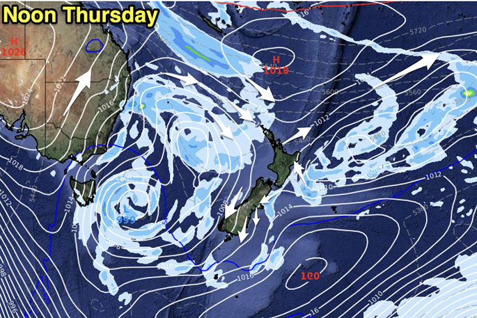
Image: WeatherWatch.co.nz
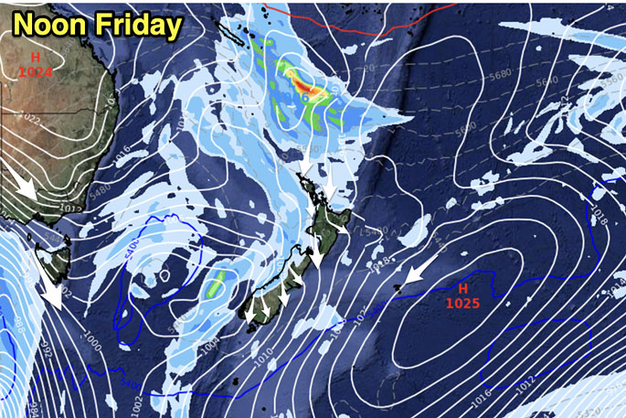 Image: WeatherWatch.co.nz
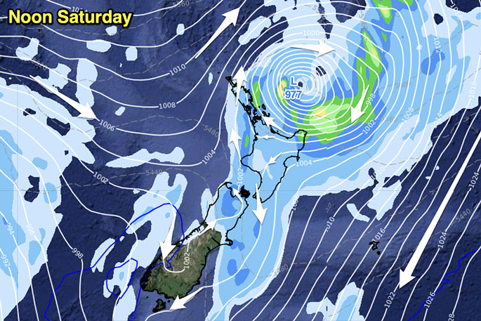 Image: WeatherWatch.co.nz
If this occurs the media have permission to use the term "Weather bomb!".
Technical name: Bombogenesis - Explosive cyclogenesis: https://t.co/xB8Xn53MwW https://t.co/i2QTEFX86j— WeatherWatch.co.nz (@WeatherWatchNZ) July 17, 2024
#Temperatures - Departure from *Normal. With the exception of the eastern North Island, most places are a few to several degrees above average this Friday and Saturday.
— WeatherWatch.co.nz (@WeatherWatchNZ) July 16, 2024
*Normal being what is usually recorded at this time of year over the past few decades. pic.twitter.com/EFwPAtKTHU
The large low in the Tasman Sea collapses on Friday, but then all eyes shift to the north east of #NZ for a potential offshore storm scooting past on Saturday.
— WeatherWatch.co.nz (@WeatherWatchNZ) July 16, 2024
You can see in the final frame that rain & showers cover a large part of the North Island by Friday night. pic.twitter.com/1a4ITq4I9O

0 comments
Leave a Comment
You must be logged in to make a comment.