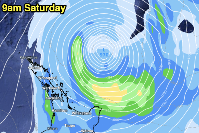
A low pressure zone is this morning peaking in power as it tracks very near the upper to north-eastern side of the North Island, says a WeatherWatch spokesperson.
The centre of the zone is expected to remain offshore.
"The storm formed rapidly overnight and is being described as a 'weather bomb'," says a WeatherWatch spokesperson.
The technical name is bombogenesis, or explosive cyclogenesis.
"This is when a low pressure system drops more than 24 hectoPascals in 24 hours. In simple speak: The air pressure drops fast and a storm forms within a day."
It's also known as an extratropical cyclone or mid latitude cyclone, and means this storm has formed outside of the tropics with gale force winds around the centre.
"However extratropical cyclones don't have a warm core like a tropical cyclone does - and it's this colder setup that means they behave differently to tropical cyclones.
"But in a general sense they look very similar in satellite and isobaric maps - and can produce equally damaging winds."
WeatherWatch says rain in extratropical cyclones is often more broken up than tropical cyclones, and usually often only covers half or even just one quarter of the entire low pressure zone.
"Tropical cyclones usually have rain around the entire centre - the full 360 degrees.
"The air pressure in this storm today is only slightly higher than Gabrielle was last year - which was 965hPa - but overall this storm isn't as powerful as Gabrielle and certainly doesn't pose anywhere near the same risks in this shape and form.
"It's also remaining offshore and is only 'nicking' the tip of East Cape with the worst of the weather, although wind and rain may be felt further away from Northland and Auckland down to Hawke's Bay.
"There's a high chance most of the severe weather will be offshore, but some might brush the north-eastern North Island and the upper North Island."
People are encouraged to keep up to date with the latest MetService warnings and watches here.
A deep subtropical low to the northeast of the country is directing a moist southeasterly flow over the North Island, which is bringing further heavy rain to Tairawhiti/Gisborne until evening.
The MetService says the rain should then ease as the low moves slowly away to the east and winds turn southwest.
The Heavy Rain Warning for Tairawhiti/Gisborne north of Gisborne City is valid for nine hours from 8am - 5pm, Saturday, July 20.
"Expect 40 to 70 mm of rain on top of what has already fallen, with the largest amounts likely north of Tolaga Bay. Peak rates of 10 to 15 mm per hour," says a MetService spokesperson.
"Streams and rivers may rise rapidly. Surface flooding, slips, and difficult driving conditions are possible. Clear your drains and gutters to prepare for heavy rain. Avoid low-lying areas and drive cautiously."
Chatham Islands
Meanwhile, a trough associated with the low, which is preceded by easterly gales, is forecast to move southwards over the Chatham Islands on Sunday morning.
A Strong Wind Watch for the Chatham Islands is valid for 12 hours from 9pm Saturday, July 20 to 9am Sunday, July 21.
People are advised to stay up to date with forecasts in case changes are made.
Watches no longer in Force
A Heavy Rain Watch has been lifted for Northland, Auckland north of Whangaparaoa Peninsula, and Great Barrier Island. Heavy Rain Watches have also been lifted for Coromandel Peninsula, Bay of Plenty west of Whakatane and Tasman west of Motueka.
"The threat of rainfall amounts reaching warning criteria has passed and the Watch is now lifted," says a MetService spokesperson.
Sunday
By Sunday the storm is gone - east of Chatham Island. says WeatherWatch.
"Elsewhere the weather pattern is fairly quiet this weekend but a surge of wind and showers, maybe some isolated thunderstorms too, are possible in the western North Island on Sunday as the next low in the Tasman Sea moves in," says a WeatherWatch spokesperson.

0 comments
Leave a Comment
You must be logged in to make a comment.