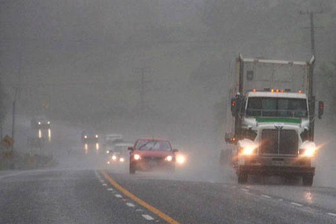
Periods of heavy rain and snow are being forecast for parts of the country.
The MetService says southeasterly gales are also possible for western parts of the South Island.
A severe weather watch for heavy rain is now in place for the Bay of Plenty, including Tauranga.
"A low over the Tasman Sea is forecast to affect the country from Monday to Wednesday," says the MetService is in it's latest weather update.
"Persistent and cold easterlies are expected to develop over the southern South Island, bringing heavy rain and heavy snow above 300 metres."
Mōrena, good morning
— MetService (@MetService) July 28, 2024
Parts of the South Island are waking up to a wet morning, and some spots in the North Island are already seeing a few showers
This wet weather will extend to more areas of the North Island throughout the day, so keep those umbrellas close by pic.twitter.com/6EyMIRt97H
"Southeasterly gales are expected to develop over western parts of the South Island late Monday and Tuesday," says the MetService.
Watches and Warnings are in force for a large part of the country.
"People are advised to keep up to date with the latest forecasts."
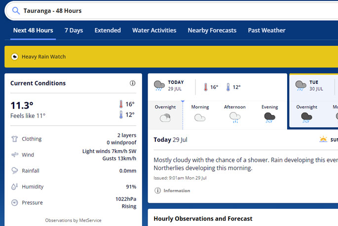 Image: MetService.
Heavy Rain Watch
Area: Bay of Plenty east of Opotiki
Period: 12 hours from 1am Tue 30 Jul to 1pm Tue 30 Jul
Forecast: Period of heavy rain, and amounts may approach warning criteria.
Low chance of upgrading to a Warning.
Area: Mount Taranaki/Taranaki Mounga
Period: 9 hours from 3:00pm Mon 29 Jul to 12:00am Tue 30 Jul
Forecast: Periods of heavy rain, and amounts may approach warning criteria.
Low chance of upgrading to a Warning.
Area: The Bryant and Richmond Ranges, also the Rai Valley
Period: 9 hours from 3pm Mon 29 Jul to 12am Tue 30 Jul
Forecast: Period of heavy rain, and amounts may approach warning criteria.
Low chance of upgrading to a Warning.
Area: The Westland District
Period: 12 hours from 9am Mon 29 Jul to 9pm Mon 29 Jul
Forecast: Periods of heavy rain with possible thunderstorms, and amounts may approach warning criteria, mainly about the ranges.
Low chance of upgrading to a Warning.
Area: Southland and Clutha about and northwest of Raes Junction
Period: 15 hours from 9am Mon 29 Jul to 12am Tue 30 Jul
Forecast: Periods of heavy rain, and amounts may approach warning criteria.
Low chance of upgrading to a Warning.
Heavy Snow Watch
Area: Inland areas of Otago and Southland as well as eastern Fiordland
Period: 33 hours from 9:00am Mon 29 Jul to 6:00pm Tue 30 Jul
Forecast: Periods of heavy snow above 800 metres during Monday morning, where snowfall amounts may approach warning criteria.
Note, snow level is expected to lower to 300 metres Monday night.
Moderate chance of upgrading to a Warning.
Area: North Canterbury high country and the foothills north of the Rangitata River
Period: 26 hours from 10:00am Tue 30 Jul to 12:00pm Wed 31 Jul
Forecast: Rain is expected to gradually turn to snow above 400 metres during Tuesday where heavy snowfall is possible. Amounts may approach warning criteria.
Moderate chance of upgrading to a Warning.

0 comments
Leave a Comment
You must be logged in to make a comment.