
After a wet and wild start to the week, calmer conditions are being forecast for most as we reach the weekend.
A ridge of high pressure is set to build over much of the country, ushering in fine weather, while a low pressure centre brings rain to northern regions.
“Northland, and potentially Auckland and the Coromandel, can expect strengthening winds and some wet weather for the next few days, so keep an eye out for severe weather information,” says MetService meteorologist Alwyn Bakker.
Elsewhere, the building ridge will bring clear skies and frosty starts. Temperatures are set to drop, with much of the country forecast to be colder than usual overnight.
Nearly all of the South Island main centres can expect freezing nights, with only Dunedin and Westport remaining above zero for the next few days.
Kaikōura will have a particularly chilly time overnight Saturday into Sunday.
“While Kaikōura’s forecast minimum temperature of -2°C isn’t the lowest around, that’s eight degrees lower than its average at this time of year,” Bakker notes.
It will be a little warmer up in the North Island, however, most locations south of Auckland will see low single digits overnight.
It will also be a cold start for those participating in the Taupo Marathon on Saturday, with temperatures dropping to -1°C the night before. Luckily, the clear conditions should give excellent views of the Lake.
The low temperatures are good news for some.
Many ski fields saw a decent dumping of snow earlier in the week, and as the ridge builds and winds ease, conditions are looking good for a day on the slopes this weekend. However, take care on the journey there.
“Road conditions may be hazardous in some locations, as those lower temperatures allow existing ice to stick around for longer,” cautions Bakker.
Towards the end of the weekend, the ridge starts to move away, and a band of rain will approach the South Island from the west.
Meanwhile, the low affecting the upper North Island will gradually head east, but at this stage its exact path is still up in the air.
“We advise people keep up to date with the latest forecasts over at metservice.com.” says Bakker.
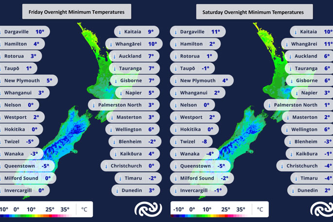 Image: MetService.

0 comments
Leave a Comment
You must be logged in to make a comment.