
After a spell of mid-week sunshine across New Zealand, MetService is predicting a weekend of wet and windy weather, quickly followed by snowfall in inland parts of the South Island and a shift to colder temperatures.
This change comes as a northwesterly flow brings warmer conditions to the east of the country over the next few days.
Saturday is expected to get wetter as the day goes on for the North Island as a weather system connected to a low pressure system in the Tasman Sea approaches.
"Any outdoor activities would be best done in the morning. By the afternoon and evening, rain will spread across the island, reaching Tairāwhiti/Gisborne, Hawke’s Bay, and Wairarapa in the evening. While the rain will be widespread, the heaviest accumulations are expected in localised, mostly elevated areas," says MetService meteorologist Mmathapelo Makgabutlane.
"The top of the South Island is also set to receive rain as the weather system advances.
"How far south the rain reaches will depend on the movement of the low pressure system. Tasman, Buller, and Marlborough look likely to see rain, and anything further south is still to play for."
Thursday and Friday will see breezy westerlies across much of the country, but by Saturday afternoon, these will shift to blustery northerly winds.
The eastern, central, and lower North Island, in particular, can expect a gusty weekend.
"Keep an eye out for any further Watches or Warnings in the coming days, in addition to the Heavy Rain Watches currently in place."
After a brief reprieve early Sunday morning, another pulse of rain is expected to sweep across the North Island, with rain extending to parts of the South Island as well.
From Sunday afternoon and into Monday, colder, showery southwesterlies bring the possibility of snowfall to inland areas of the South Island.
"This is an early heads up to farmers with young stock, as well as road users who might be traveling along some of those elevated roads and mountain passes.
"Into next week, however, there is a chance the snow could go down to lower levels for places like Southland and Otago."
While the South Island gets plunged back down to cold temperatures by the end of the weekend, the east of the North Island will see a period of warmer-than-average temperatures from Thursday to Sunday, ranging from 17 to 21°C.
"Although these temperatures are reminiscent of warmer seasons, the combination of cloud, rain, and wind will remind us that winter isn't over just yet."
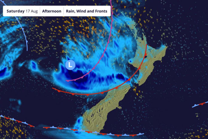 Image: MetService.

0 comments
Leave a Comment
You must be logged in to make a comment.