
Rain and strong winds are being forecast for many parts of New Zealand, with a more widespread weather system bringing wet weather, possible snow and a drop in temperatures later in the week.
However, brighter conditions are in store for Wednesday.
The last few weeks have been characterised by wet weather moving furiously across the country.
On Sunday, thunderstorms swept across parts of the North Island, resulting in over 22,000 lightning strikes, 7000 of these over land, and power outages. This trend of rapidly-moving bands of rain is set to continue.
On Monday, rain was expected over the western South Island with showers in other areas of the South Island and western North Island.
However, many regions can look forward to some blue skies as the rain tracks north. This respite will be short-lived, as another round of wet weather is expected on Tuesday, accompanied by thunderstorms, hail and possible snowfall in inland Southland and Otago, along with gusty westerly to southwesterly winds across both islands.
“The strongest winds will be felt in Central Hawke’s Bay, the Tararua District, and the Wairarapa, where an Orange Strong Wind Warning is in place for Tuesday, with gusts of 120 km/h possible," said MetService meteorologist Mmathapelo Makgabutlane.
"Strong Wind Watches are also in effect for much of the South Island. Thunderstorms in the western and lower South Island may bring additional gusty winds as they pass through.”
The most widespread rain of the week is expected on Thursday and Friday, as a large weather system moves over the country.
While the largest rainfall accumulations are expected in the western South Island, most reaches of Aotearoa can expect a decent bout of rain, first for the South Island on Thursday, extending to the North Island on Friday.
Other hazardous conditions are expected with this weather system.
":In addition to rainfall, strong winds will sweep across the country, affecting the South Island and lower North Island. Snowfall makes a return, mainly for inland parts of the South Island, which may impact road travel on high-level roads and mountain passes.
"This will also have a flow-on effect on temperatures as they take a dip, especially over the South Island. In a nutshell, almost all of Aotearoa will see something from this weather system.”
While the week begins and ends with active weather, Wednesday brings a brief respite.
“Sunnier and drier conditions will give those umbrellas a much-needed break, offering an opportunity to get some laundry dried. The only trade-off will be a chillier start to the day with many low single-digit minimum temperatures, and some parts of the South Island even dipping below zero."
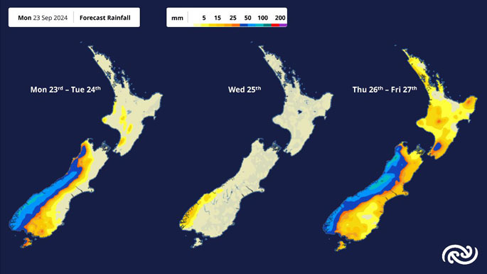 Image: MetService.

0 comments
Leave a Comment
You must be logged in to make a comment.