Power is out to 100 homes in Whitianga, a tree is blocking State Highway 25, and there is minor flooding and debris on other roads in the Coromandel area following heavy rain overnight.
Thames-Coromandel District Council said 100mm of rain fell across the peninsula overnight, and it was still raining at 7am.
"High tide is at 8.30am this morning, meaning that all streams and rivers are running high until later in the morning.
"Take extreme care if travelling or walking the dog this morning," the council advised.
Have you been affected by the weather? Share your stories and pictures with us at newsroom@thesun.co.nz
About 100 homes in Whitianga were without power on Thursday morning, with reports of surface flooding and debris on roads in the area, a tree was blocking SH25 at Kūaotunu.
It said, PowerCo was working to restore power.
Thames Coromandel civil defence controller Gary Towler told Morning Report the rain and wind had caused "minor" issues.
"It was a good overnight delgue, 100mm of rain is normal for Coromandel, but it was testy.
"Typical spring for us."
He said the rebuild done after Cyclone Gabrielle meant things were more resiliant than they were and there wasn't the "carnage" there may have been in the past.
Towler said power was expected to be back mid-morning.
There were "debris around the (roading) network" and drivers should take care, he said.
Rain elsewhere too
After a night of heavy rain in much of the country, Thursday was promising another day of severe weather with thunderstorms, wind and snow forecast.
Coromandel and the Bay of Plenty had the worst of the weather overnight, MetService Duty forecaster Heath Gullery said.
Taranki had 100-150mm of rain while Tasman had up to 250mm in some areas.
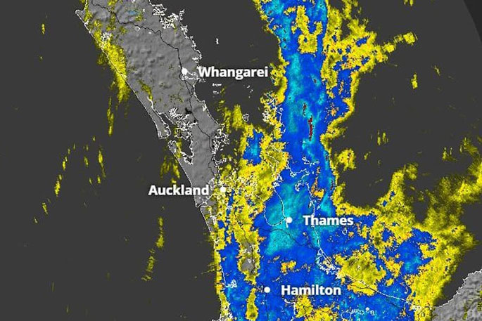
MetService's rain radar showed the rain band moving across the upper North Island and the centre of the country early Thursday morning.
MetService meteorologist John Law told Morning Report the "band of rain" was likely to be stuck over the country for a few days.
The wet weather was taking it's time moving on from Coromandel and Bay of Plenty but in general things would clear up in the North Island during Thursday, he said.
However things would ramp up in the southeast of the South Island, Law said.
"It's an incredibly wet situation down across the likes of Otago."
But he said there were "plenty of severe weather watches and warnings" nationwide.
And it was likely to remain wet over the weekend, Law said Northland, Auckland, and Waikato should expect more showers then.
In the afternoon, up to two months' worth of rainfall could hit in parts of the South Island, National Institute of Water and Atmospheric Research (NIWA) said .
NIWA forecaster Seth Carrier said Thursday would see "a plume of moisture coming down from the north", carrying heavy rain that could impact the Bay of Plenty and East Cape, before the heavier rain crops up in the South Island.
Warnings and watches
The MetService has issued a swath of warnings and watches.
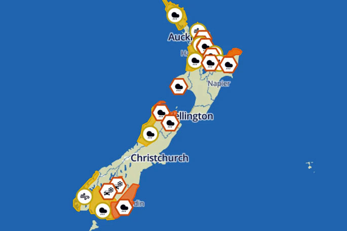 Photo: MetService/screenshot.
Northland, Waikato and Waitomo, Southland were under yellow heavy rain watches
Orange heavy rain warnings were in place for Coromandel Peninsula, Mount Taranaki, Bay of Plenty, North Otago, Dunedin and Clutha.
A severe thunderstorm watch runs until 11am for Coromandel Peninsula, Bay of Plenty, Rotorua, and Gisborne.
A strong wind watch was in place for Great Barrier Island, Coromandel Peninsula, Bay of Plenty, and northern Tairawhiti.
There was a road snowfall warning for Lindis Pass (SH8) and Crown Range Road.

0 comments
Leave a Comment
You must be logged in to make a comment.