Thames-Coromandel District Council (TCDC) has released its flood map of Whangamatā, showing which areas were likely to be inundated at different levels of rainfall.
A spokesperson for the council said the modelled stormwater flooding map would inform a programme of infrastructure work to mitigate flooding and help property owners better manage associated risks.
More than $9 million has been budgeted for stormwater improvement work in the town over the next six years, with the council now implementing a communication plan.
The council approved the floodwater modelling study at its meeting on Tuesday last week and the digital map showing the modelling and supporting information went live on Friday.
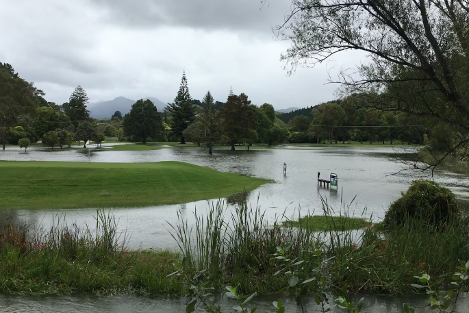 Whangamatā Golf Course after Cyclone Hale in January last year. Photo / Lynley Ward.
The model was developed using National Institute of Water and Atmospheric Research (Niwa) data and was based on a stormwater flooding event with a 1% annual exceedance probability (a one-in-100 chance of happening in any year).
“The information provided by the flood model allows us to understand geographic areas that are likely to be affected by this type of flooding and associated risks,” the spokesperson said.
“It also helps our community to be better prepared and become more resilient to potential future flooding events.”
Whangamatā property owners would soon receive a letter, with drop-in sessions confirmed to allow them to speak to staff and get more detailed information.
Whangamatā resident and Thames-Coromandel Deputy Mayor Terry Walker said the flood map would inform residents about how the town would hold up during various levels of rainfall.
“It is telling us that Whangamatā is like a big sand dune; it goes up and it goes down. You will have a big swale effect.”
Walker said the $9m figure was just a starting point.
“It will be a lot more; that [$9m] will do 11 hot spots to increase pipe sizes to assist with run-off so water doesn’t pond.
“When we get into this project, we will find other things – we want to get this right.”
Walker said stormwater management in the town had long been a contentious issue.
“One of the advantages in Whangamatā is there is no velocity, our water comes straight from the sky. It’s just dealing with water when it hits the ground.
“This is a project we have worked on since 2018 and it will be a benefit for the future.”
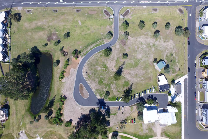 A view of Williamson Park from the air shows the pond to the left, which was drained and backfilled earlier this year.
Physical works got under way in June at Williamson Park to improve water flow in the Williamson and Ocean Roads stormwater pipe network.
A crucial element of the project had been to model flooding in Whangamatā to guide decision-making on new developments in order to gauge where infrastructure investments were needed to mitigate flooding risk for existing properties and inform property owners of the potential risk.
An insurance perspective had been applied to the flood inundation mapping exercise, and from an insurer’s perspective, four important messages for the council had been consolidated into its thinking about the planned actions it took and its approach.
Insurers expected the council to act as “prudent uninsured”, as the council owed a duty of care to the community. Insurers could view things dimly if available information was not acted upon. By acting on the information it now had, the council was acting in a reasonable manner and needed to know and consider its statutory obligations.
Whangamatā had experienced significant stormwater flooding due to weather events over the past 20 years, including during the severe storms in January and February last year.
The proposal to improve the town’s stormwater kicked off in 2017 following flooding and it was presented to the Long-Term Plan (LTP) in 2018.
In 2021, $1.2 million was earmarked for a working plan, then in 2022 the council began the multi-year Whangamatā Stormwater Improvements project with the aim of expanding the capacity of infrastructure so it could handle increased amounts of stormwater generated by weather events.
An integral aspect of the model had been the development of floodplain mapping, dividing the township into 16 grid sections to overlay flood inundation data.
The mapping highlighted the “susceptibility” of many properties to flooding under different recurrence intervals.
Drop-in sessions at the Whangamatā TCDC meeting room, 620 Port Road:
- Wednesday, November 6: 10am-2pm
- Monday, November 11: 10am-1pm
- Friday, November 15: 3-6pm
- Tuesday, November 19: 10am-1pm

0 comments
Leave a Comment
You must be logged in to make a comment.