Cyclone Pam is expected to track down the East Coast of New Zealand on Sunday and Monday, according to the latest forecast from Metvuw.com.
Currently the cyclone is sitting in the Pacific Island region and is expected to shift towards New Zealand.
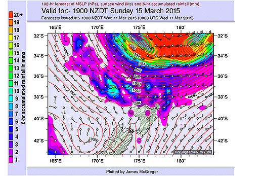
Cyclone Pam is predicted to side-swipe the east coast of New Zealand as it passes the country on Sunday and Monday. Image: Metvuw.com.
Heavy rain and strong winds are predicted to hit the North Island from about 1pm on Sunday and last for around 24 hours as the edge of the storm skirts past the country.
Before then, the MetService is forecasting a moderate risk of thunderstorms for Auckland and the Coromandel today.
A combination of warm, converging winds this afternoon and cooling is expected to produce scattered showers, some heavy at times, with possible thunderstorms for most of the North Island.
There are currently no weather warnings in place for the Bay of Plenty, but the MetService says there is a chance of severe weather as systems move over the country and Cyclone Pam edges closer.
The MetService says: 'Pam is expected to remain east of New Zealand, but parts of the North Island are likely to be affected by severe weather on Monday, especially Gisborne and northern Hawke's Bay, where there is a high confidence of heavy rain and severe southeast gales, possibly starting late Sunday,”
For Northland, northern Auckland and the Coromandel Peninsula there is a low confidence that rain could become heavy late Sunday and southeast gales could become severe.
'However, the confidence increases to moderate on Monday, for both warning amounts of heavy rain in these areas and also severe gales,” they add.
'Southeasterlies are expected to turn southwest as the low tracks further south on Monday and there is also a risk of severe southwest gales.”
Further south, there is a low confidence of rainfall accumulations reaching warning criteria in central and southern Hawkes Bay and also Wairarapa on Monday.
In addition, strong southeasterlies are likely to affect the remainder of the North Island and there is a moderate confidence that these could become severe around Auckland City, Waikato and the Bay of Plenty.
Winds may turn southwest later on Monday around Auckland, and these southwest gales could also be severe.
'There is a low confidence of severe southeast gales for the rest of the North Island and the Marlborough Sounds on Monday,” says the MetService.
'There is still considerable uncertainty regarding the track of Pam and severe weather watches and warnings will be issued as the situation evolves.”

1 comment
Maybe.......
Posted on 13-03-2015 06:22 | By Jimmy Ehu
but be warned there will be enough of it to put the wind up your skirt, and I wonder how many "dumb arses" will think its a good time to go fishing?.
Leave a Comment
You must be logged in to make a comment.