A severe weather watch is in place for northern and eastern parts of the North Island as Tropical Cyclone Pam tracks southeast towards New Zealand.
And a statement from Bay of Plenty Civil Defence says that while not enough detail is known yet about how the cyclone will track, it's expected to bring high winds, heavy rain and very large swells - particularly in the eastern part of the region.
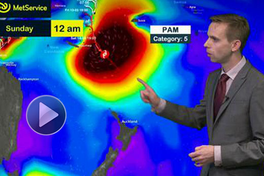
Tropical Cyclone Pam is expected to pass east of the country on Monday and hit the Chatham Islands on Monday night.
At 1pm today, the cyclone was located 220 kilometres northeast of the capital of Vanuatu, Port Vila, and moving slowly southwards.
Now a category five storm, it carrying winds of up to 220 kilometres per hour near the centre, with gales extending out to 300 kilometres or so from the centre.
A Tropical Cyclone Warning is in force for Vanuatu where destructive winds, torrential rain and phenomenal seas are expected until Saturday morning as the system passes just to the east of the island group.
TC Pam is expected to move out of the tropics on Sunday morning and continue on a southeast track towards New Zealand.
Based on the latest forecast, it is expected to be just to the east of East Cape on Monday before passing near the Chatham Islands on Monday night.
The MetService issued a severe weather watch for northern and eastern parts of the North Island, where heavy rain and south to southeast gales are expected from Sunday evening through to Tuesday.
MetService Meteorologist Peter Little says Tropical Cyclone Pam remains an extremely deep low as it passes east of New Zealand.
'So it is likely that parts of the watch will be upgraded to a warning over the weekend,” he says.
Aside from the heavy rain and gales that Tropical Cyclone Pam is expected to bring, heavy swells are likely to affect much of the east coast early next week.
Regional Harbour Master Peter Buell says boat owners should check their moorings and ensure their boats are secure, with hatches closed and sails tied down before the storm arrives.
Loose equipment needs to be stored securely and gas bottles closed. Boaties should also make sure they have a current mooring certificate for insurance purposes in case their boat is torn from its mooring in the storm.
Homeowners are being advised to clear their gutters and secure outdoor furniture and rubbish bins, while farmers should ensure equipment is safely stored and animals are in a safe place or moved to higher ground if necessary.
Keep up-to-date with the latest forecasts at: www.metservice.com or: www.m.metservice.com on mobile devices.
MetService TV can also be followed on the MetService New Zealand Facebook page, @metservice on Twitters or at: www.blog.metservice.com

0 comments
Leave a Comment
You must be logged in to make a comment.