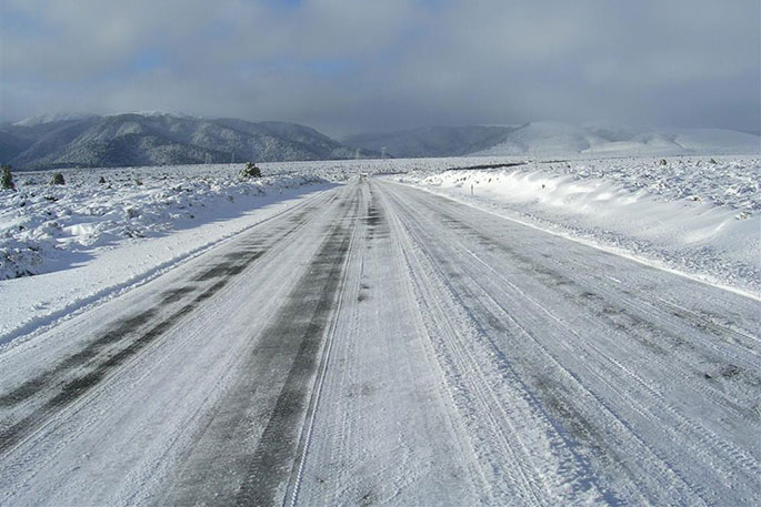
New Zealand is into the depths of winter now with moisture meeting the cold next week creating heavy snow in both islands.
'Southland and Otago may see snow falling as low as around Dunedin and near/around Invercargill.
'At this early stage WeatherWatch.co.nz believes the snow won't be reaching sea level, or at least not settling there and causing issues.
'However the low level and heaviness of this snow may cause travel problems through the South Island and central North Island and, depending on timing, there is certainly the risk snow cause transport issues in Dunedin, even to sea level (again, timing will be key for that).”
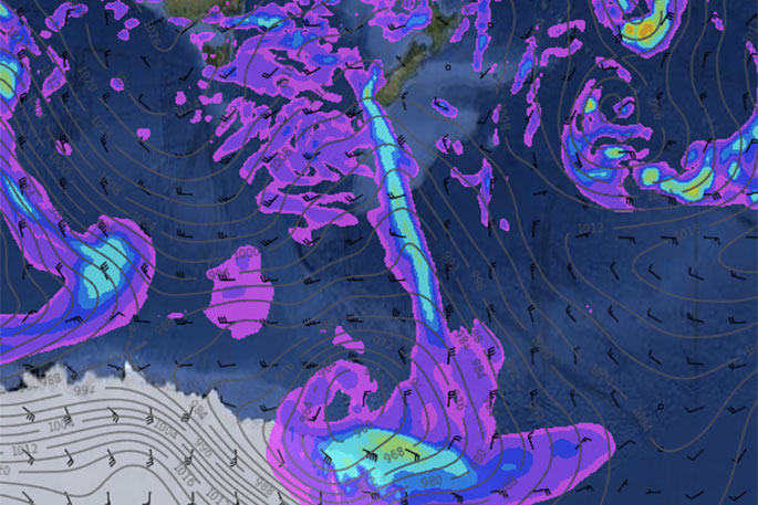
 Tuesday's Future Rain/Snow Radar shows a low hugging the Antarctic coastline and sending a cold front into the lower South Island, eventually reaching the North Island Weds/Thurs (at this stage).
Frequently Asked Questions (FAQs)
What is happening and when?
On Tuesday a deep low a few thousand kilometres south of the South Island will send a burst of moisture and cold air from over the Southern Ocean into the South Island. This will push snow to very low levels in the lower half of the South Island and produce widespread heavy snow above 200m.
It will spread into the North Island on Wednesday and Thursday where it will push into a low centred over the North Island bringing moisture rich air from just north of the country back down and into the colder air. This rain will be fed in via an easterly quarter flow, placing the Hawke's Bay ranges and Central Plateau areas at risk of heavy snow for a couple of days where the southerly meets.
Where will the snow fall?
Please note snow may be brief and not even settle for some, for others it may be heavier and settle for days. Just like with rain and showers, snow can be patchy and therefore heavier for some while others nearby may completely miss out. This is not a major storm - but it is possibly the lowest snow fall of the year so far. Snow at higher altitudes (ie above 200 or 300m) may be quite widespread in the South Island and above 400 or 500m in the North Island.
Which main centres will get snow?
At this stage WeatherWatch.co.nz believes the following main centres may get snow for a time on Tuesday: South Island: Dunedin, Gore, Alexandra, Queenstown, Cromwell, Arrowtown, Wanaka and possibly Ashburton overnight Tuesday and into Wednesday AM. (We may not have listed all towns, but if you live in the area no doubt you get the idea).
Christchurch - at this stage - is unlikely to get snow, but we'll monitor it. Snow in Canterbury may be down to 200m but again, like rain, amounts and snow levels will vary across regions due to the mountains and ranges, coastal conditions and wind/air flows at the time...and timing will matter too, overnight has a higher chance of pushing snow down to lower levels.
North Island: Waiouru, Ohakune, Taihape are all highly likely to receive snow, so too National Park. Stratfordand Eketahuna both have some chance. Taupo is not expected to get snow but it will be nearby and low on Mt Tauhara and surrounding plateau/hills.
Which highways may be affected?
Many South Island highways will be affected around Southland, Otago, Canterbury and through/over the Southern Alps for a time.
ALL ALPINE HIGHWAYS are likely to get snow at some point and some may be closed. State Highways and side roads in Dunedin may be impacted for a time but it's unclear how heavy it will be and at what altitude - we will really need to wait until Monday to lock that in. Dunedin, being coastal and hilly is always a tricky place to lock in for these borderline sea-level snow events (and this is borderline for sea level by about a degree or two).
In the North Island SH2 over the Rimutaka Ranges is likely to be impacted, perhaps on Wednesday night.
SH1 the Desert Road is HIGHLY LIKELY to receive snow, as too are ALL HIGHWAYS AROUND MT RUAPEHU. If snow closes the Central Plateau highways lengthy detours will go via Hawke's Bay or Taranaki. SH5 from Napier to Taupo will also likely be impacted by snow on Wednesday or Thursday with snow expected to fall down to Rangitaiki.
Which airports may be impacted?
Hard to say as airlines, airports and pilots make decisions on whether they will fly or not, but it's fair to say the weather could impact flights/airports at Dunedin, Invercargill and Queenstown. This may therefore impact some other flights/airports anywhere in NZ, especially if snow grounds any planes at an airport.
Which ski fields will get snow?
Every single one of them! Oh, with the exception of Auckland's indoors Snow Planet :)
How far north will the snow fall?
The Gisborne ranges and probably the Coromandel Peninsula and Kaimai Range peaks.
Is it a storm?
No it is not. In the South Island it's a fairly straight forward snowy/cold period of weather for July. It's definitely worth warning about though, especially for farmers and those who need to use the highways and airports. However as the cold change moves into the North Islands things get far more complicated due to a large low expected there mid-next week. This low will be pulling in winds north of the country for a time, this will add moisture (and warmth) into the rain over the North Island - but there will be a line where the colder southerly moves into this moisture and therefore snow could be quite heavy in the North Island ranges and mountains for a couple of days. One to monitor as this is a bit unpredictable, especially 4 or 5 days out.
What's the timing of it again?
Starts Tuesday AM in Southland and Otago. - Reaches Canterbury into Tuesday PM and Wednesday AM. - Wednesday PM, across Thursday and early Friday AM for the North Island ranges and Central Plateau.


1 comment
cold temp.
Posted on 10-07-2017 21:41 | By phoenix
The al gore measure of global warming is definitely,and conclusively alive and well in NZ Maybe?
Leave a Comment
You must be logged in to make a comment.