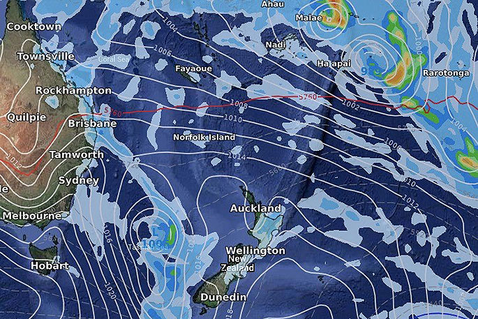
UPDATED 11:01AM: A new tropical cyclone has formed north west of New Zealand and east of Queensland over the Coral Sea and has already reached Category 2 status - with another cyclone likely to form north east of New Zealand and Fiji later this week.
Cyclone Uesi was named by the Fiji Met Service overnight and as of 11am Monday NZDT it had grown to a Category 2 tropical storm near Vanuatu to the west. It's far enough away from VANUATU to minimise serious impact at this stage.
Instead, it's expected to strengthen in the days ahead and may even reach Severe Category 3 status as it moves southwards near or directly over New Caledonia around Tuesday and Wednesday, says WeatherWatch.co.nz
"The French island may be directly impacted by Uesi with damaging winds, flooding rains and dangerous seas.
"On Friday, Cyclone Uesi - or the remnants of the storm - will be near Eastern Australia and will help feed even more heavy rain into the east from Brisbane and Sydney.
"It will also produce dangerous seas and waves. It will then grow into an extra-tropical storm which could see it intensify - hence why eastern Australia and the South Island of New Zealand should be monitoring."
High pressure looks to remain in place over New Zealand this week with an easterly flow at the top of the country helping to guide this cyclone westwards towards Australia and then southwards down the Tasman Sea by the weekend.
One week from now the remnants of Uesi will likely drop away into the Southern Ocean between Tasmania and Fiordland - but there is a chance it could pull closer to NZ and bring heavy rain to the West Coast in a week from now. Modelling, unfortunately, seems to agree the North Island won't likely be exposed to rain from this event.
ANOTHER BIGGER CYCLONE AFTER:
As the remnants of Uesi drift closer to NZ early next week a much larger tropical cyclone will likely be to our north.
"As early as this Friday the next storm will be forming north to north east of Fiji, " says WeatherWatch.co.nz
"The islands of Tonga look most exposed next Monday, February 17, to a possible direct hit. This second tropical cyclone may also feed very heavy rain into Samoa.
"By next Wednesday (February 19) this second cyclone should be well east of New Zealand, nor bringing much needed rain to the North Island due to high pressure being stuck in place over NZ still."
EARLIER:
A new tropical cyclone has formed north west of New Zealand and east of Queensland over the Coral Sea with another cyclone likely north east of NZ next week.
Cyclone Uesi was named by the Fiji Met Service and as of 8:45am Monday NZDT was a Category 1 tropical storm near Vanuatu to the west.
It is expected to strengthen in the days ahead and reach Category 2, maybe even Severe Category 3 as it moves south towards New Caledonia, then into the Tasman Sea area, says WeatherWatch.co.nz
"It's like Uesi will brush the western side of New Caledonia on Wednesday - or go directly over the French island.
"On Friday this week Cyclone Uesi - or the remnants of the storm - will be near eastern Australia and will help feed even more heavy rain into the east from Brisbane to Sydney.
"High pressure looks to remain in place over New Zealand with an easterly flow at the top of the country helping to guide this cyclone westwards towards Australia and then southwards down the Tasman Sea."
One week from now the remnants of Uesi will likely drop away into the Southern Ocean between Tasmania and Fiordland - but there is a chance it could pull closer to NZ and bring heavy rain to the West Coast in a week from now. Modelling, unfortunately, seems to agree the North Island won't likely be exposed to rain from this event.
ANOTHER BIGGER CYCLONE AFTER:
"As the remnants of Uesi drift closer to NZ early next week a much larger tropical cyclone will likely be to our north. As early as this Friday the next storm will be forming north to north east of FIJI.
"The islands of TONGA look most exposed next Monday, Feb 17, to a possible direct hit. This second tropical cyclone may also feed very heavy rain into SAMOA."
By next Wednesday (Feb 19) this second cyclone should be well east of New Zealand, nor bringing much needed rain to the North Island due to high pressure being stuck in place over New Zealand still.

0 comments
Leave a Comment
You must be logged in to make a comment.