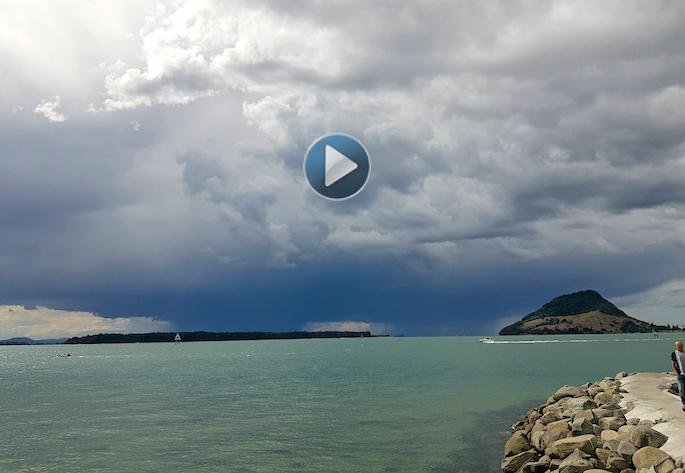
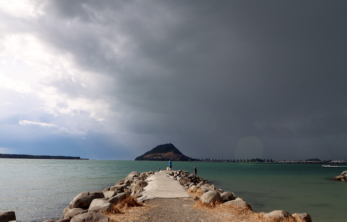
SunLive photographer Daniel Hines has captured a time lapse of the thundery storm clouds as they passed across the Tauranga harbour late this afternoon.
The spectacular sight lasted about an hour and was caught on camera by Daniel, who was filming at Sulphur Point.
"It was like two fronts that joined together," says Daniel.
The storm clouds passing overhead moved quickly from west to east from about 4pm to 5pm.
"The thunder was constantly rumbling, with a heavy downpour at the end."
Following the stormy burst, which also caused some flash flooding and hail, it was reported that there had been some damage to trees in the area.
WeatherWatch report that for the week ahead, it's a case of yin and yang across New Zealand on Monday with cloud along the North Island's eastern side while the east of the South Island is mostly sunny, report WeatherWatch.
Meanwhile the North Island's western side will be sunny also, as the West Coast of the South Island becomes cloudier.
'This is the anticylonic flow moving around New Zealand as high pressure moves over the country through central areas,” says a WeatherWatch
A few showers linger around East Cape, Gisborne and maybe northern Hawke's Bay. At the opposite end of the country, in the south west of the South Island, there are also a few showers around Fiordland. It's dry elsewhere.
The next seven days ahead are also drier than average in most places although there will be a few showers here and there this week.
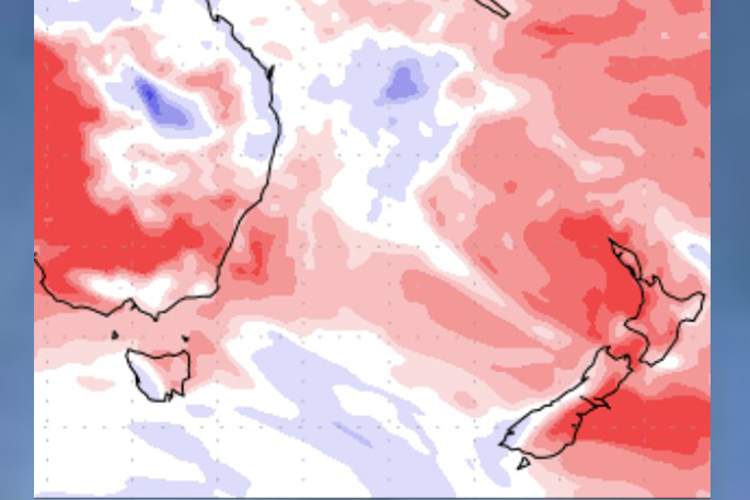
Rainfall for the next seven days compared to normal for this time of year (Red = Drier than average, White=Normal rainfall, Blue= Wetter than usual)
WeatherWatch also report that while it won't be overly warm in the eastern North Island on Monday, at least compared to normal, other regions in NZ may be several degrees above average.
'Hotter weather inland through both islands is quickly returning after a weekend cool down for many,” says a WeatherWatch spokesperson.
'Monday and Tuesday see highs bounce back to the mid to late 20s and some may even be close to 30C on Tuesday, like in Waikato.
'Tuesday's warmer weather is due to high pressure rolling in and the cooler and windier southerly flow we've had in some places over Sunday and Monday gets pushed further out to NZ's east.
'The warmer weather inland in both islands will expand further this week, so those places that are cooler than normal on Monday such as Gisborne, Hawke's Bay and coastal Wairarapa, will have a few degrees back by Tuesday and highs jump back to the mid to late 20s by the end of this week or weekend.”
Later this week more humidity will be increasing in some places with sub-tropical airflows moving to parts of both islands in time for the weekend and the start of next week.
The MetService advise that a ridge of high pressure is expected to dominate much of the country on Tuesday and Wednesday.
'On Thursday, a front should move northeast over the South Island, and may become slow moving over Buller on Friday,” says a MetService spokesperson. 'This front delivers a period of heavy rain to Fiordland, Westland and Buller, and strong north to northwesterly winds.
'Another front then approaches Fiordland from the west late Friday, delivering another period of heavy rain and strong north to northwesterly winds for Fiordland and Southland.”
There is low confidence of rainfall amounts reaching warning criteria in Fiordland and the ranges of southern Westland on Thursday, then for the ranges of northern Westland and Buller on Friday.
Another period of heavy rain is possible in Fiordland late Friday, with low confidence of rainfall amounts reaching warning criteria there, says a MetService spokesperson.
In addition, there is low confidence of north to northwesterly winds reaching severe gale in exposed parts of Fiordland and Southland for a time during Thursday and Friday.
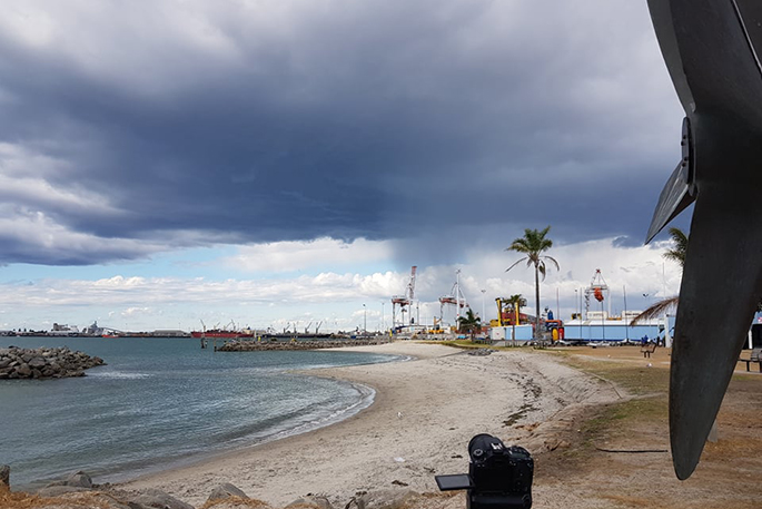
The view from Sulphur Point as the storm clouds passed by on Sunday afternoon. Photo: Daniel Hines/SunLive
Move over Vicky, we now have Cyclone WASI for Samoa and Niue
Vicky is no longer a Cyclone and has been replaced by another storm in the same area - Tropical Cyclone WASI.
It is the third tropical storm to form in a week in the region and the second named tropical cyclone. "The energy in the area has been spread out, each system has been feeding off each other which is why we're seeing a series of storms but nothing yet too major" says WeatherWatch.co.nz head forecaster Philip Duncan.
"However Wasi may be slightly better organised and could deepen into a Category 2 cyclone. The Fiji MetService says it may even get to Category 3 briefly,” says Philip.
But WeatherWatch.co.nz says computer guidance for Wasi is messy and not in agreement making this cyclone potentially harder to accurately forecast.
The US Joint Typhoon Center in Hawaii most accurately picked Vicky's short lived progress for Friday, now JTWC says Wasi has the better chance at becoming a bigger tropical cyclone, but likely out at sea and only briefly. However it's still a serious situation for parts of Samoa and then Niue. Gale force winds, possibly severe, torrential rain, thunderstorms - along with dangerous seas and beaches. With Wasi, JTWC and Fiji Met seem to be more in agreement over Wasi than they were for Vicky.
For Niue, Cyclone Wasi will hopefully be past peak power before it arrives but it's still serious for the very low lying coral island nation, with a population of just over 1600. JTWC says winds could gust to almost 130km per hour at sea and be gale force still when they reach Niue.
Some coastal flooding and sea inundation may also be possible with storm surge on Monday as Wasi moves in - but some positive news is that, like Vicky, Wasi may also have a fairly short life. For those in the area please keep up to date with official weather warnings from local Government forecast authorities.
This second cyclone may also be a little confusing for some after cyclone Vicky (which was named on Friday and gone by Saturday morning) - despite Vicky initially be warned to hit Niue. It's a bit of a messy set up which is why forecasts may change further on Sunday with Wasi and possible impacts in the region.
Wasi will not hit New Zealand, based on any modelling which shows it falling apart south of Niue next week. But the leftover energy may help feed a little more added humidity and increased chance of showers into the upper eastern North Island later next week.

0 comments
Leave a Comment
You must be logged in to make a comment.