Tauranga is awash with worry as thousands of people receive letters telling them of newly defined flood prone areas.
Tauranga City Council has sent letters to about 30,400 properties notifying people about proposed plan change 27, which refers to flooding from intense rainfall events.
The plan change introduces a new rule framework to manage the effects of flooding in intense rainfall events on people, properties and infrastructure.
Welcome Bay resident Elly Maynard received one of the letters and is now worried her property will decrease in value and her insurance premiums will go up.
She has spoken to her insurer and has been told insurance premiums will rise if properties are classed in a 1-in-100-year flood plan.
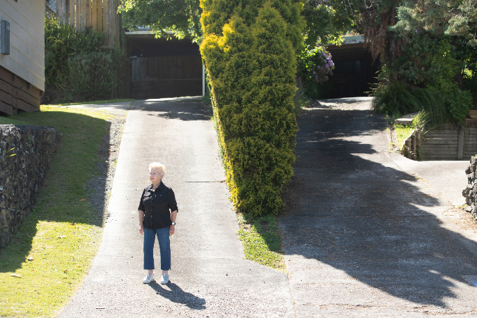
Elly says her property on Meander Drive hasn't flooded in the 30 years since it was built.
According to updated flood hazard mapping from council, her property has been identified as being in a potentially floodable area from an overland flowpath.
She has spoken with council and been told they have identified flooding coming down their driveway.
Her property is above the house in front and she says it its basic physics that water will flow down her drive, but there is no flooding coming from or going into the neighbour's property.
Elly has taken her concerns to social media site Neighbourly and says there are so many upset people with similar views.
'The whole thing is totally unfair and the way the council's handled it is just absolutely beyond belief.”
There are posts on different Facebook groups as well, with the Papamoa Link post attracting 253 comments.
She says the way the information has been communicated by council is poor and the confusion it has caused people is totally unnecessary.
Elly wants to know where council got its information from for the updated flood hazard mapping because if it's from previous flood data then it is inaccurate, she says.
Tauranga City Council strategy and growth general manager Christine Jones says to understand the risk of flooding, council undertook city-wide risk assessments.
These included flood modelling of the likely impacts of a 1-in-100-years rainfall event in Tauranga, taking into account recorded rainfall data and flood levels from past events, the contours of the land and the existing stormwater network.
It also factored in the predicted effects of climate change on rainfall and sea level rise out to the year 2130. This meets the requirements of the Bay of Plenty Regional Policy Statement requiring that the risk is reduced over time, says Christine.
'Plan changes are very technical, especially when it comes to modelling future scenarios.”
Under the plan change some developments and re-developments such as fence or wall that could block an overland flow path will require resource consent.
The plan change impacts properties differently, so council encourages people to head to their open days, book a one-on-one conversation, or call: 07 577 7700.
Elly says people need to take the power back and go to these meetings or contact council armed with information, ask for proof if they're unhappy with the classification and make a submission.
The proposed plan change came into effect from November 16 under the Resource Management Act but is subject to change through the submission process.
Submissions are open until 5pm Friday, December 18.

10 comments
Can't see a problem....
Posted on 04-12-2020 07:40 | By groutby
......in the unlikely event that sea levels will rise signiticantly if at all, and we actually do have a '1 in 100 year rainfall event'...then we can all take shelter in the unused wheelie bins we are (at this stage) going to have forced upon us...see?..no problem, they may well have a use after all !!
same
Posted on 04-12-2020 07:54 | By Kancho
We got a letter too. We received it on 24 November, it was written on the 10 November and became in legal effect on the 15 November. The local meeting dates mentioned had already passed and ringing council no booking were available to meet anyone. So very unhappy with council handling of this in effect debacle. Again water finds its own level so it seems although we live above the road and the extensive storm drains and the slope to lower ground continues across the road limiting any pooling for some reason council think flooding on downward sloping land is possible? Are they working on outdated topography with land contouring ? who knows ?seems everyone is guilty before proving innocent. Badly handled again and no wonder people are angry. Seems the meetings are for information on their methodology not on any redress. Frustration with council won't be going away
Late
Posted on 04-12-2020 08:21 | By waiknot
My notice was dated 10 Nov. it arrived on the 18th. To late for me to go to the meeting.
Make sure you make a submission
Posted on 04-12-2020 08:31 | By Womby
Elly do it ASAP I have no confidence in the system, I live up on high ground too but had water issues noted on my Lim report after I believe a drone was used to scope mine and neighbouring properties. After submitting our concerns it was reviewed and an actual property visit showed no such problems and the note was taken off the Lim report. Funny after the stress one of the so called wet areas on our property was actually the swimming pool!!
TCC late again..
Posted on 04-12-2020 10:07 | By inthweedz
Here we go again, another TCC blunder by the looks.. 1. I got the letter a week ago, waaay after the closing date mentioned.. 2. What to do now, rang the contact number, to be told it isn't connected, what the??? 3. I live at the end of a street, when I look over to the West, I am level with the Grace hospital, so if my section is prone to flooding, Tauranga will be totally submerged.. I'm asking ''Tauranga City Council strategy and growth'' general manager Christine Jones, get your staff out of their comfy office chairs, and actually check on what they are doing, and not just taking a guess..
Another stuff-up
Posted on 04-12-2020 11:13 | By Happyday
Good luck Elly, and the rest of you. I wish you all well.
Another half pie effort from the council
Posted on 04-12-2020 12:10 | By jimmyant
Agree with 'INTHWEEDZ' above. Our property borders the estuary and it shows the flooding potential for our property to be in an area that is sloped out to the estuary and from 0.5 up to 2.5 metres above the estuary high tide line. It would be a noahs arc event for our property to flood. Again they need to get off their lazy a,,, and and actually get out and look at when they are doing. Their laziness has a big impact in the REAL world on a lot of people
ANOTHER NOTHING COUNCIL TASK
Posted on 04-12-2020 14:27 | By [email protected]
Once more we are being subjected to Council spending money unnecessarily when they could be improving the city in so many other ways. Our property has never been in a flood area but all of a sudden is.............
Flooding
Posted on 04-12-2020 17:00 | By lynn
I live in Matapihi. I received letter saying I am in flooding area - hell if my place got flooding the whole of Tauranga would be under water first that's for sure. I'm higher than the strand!!!!
Insurance and valuation
Posted on 05-12-2020 11:18 | By Kancho
So we pay rates and now we are paying council to devalue properties make sure them harder to sell and increase insurance cost. Even though no flooding has ever occurred or living on higher ground where water will drain away. All without saying a word until after doing it and then making it impossible to attend meetings already passed or at difficult times. Then not being able to book a meeting at all with someone. ! Big fail again . Worrying and depressing ratepayers. we all want them to come to our houses and explain why when clearly above lower areas
Leave a Comment
You must be logged in to make a comment.