.jpg)
The Tongariro Alpine Crossing is arguably one of the most incredible day walks in the world.
We are warned though, that although beautiful, it can be dangerous if you are not fully prepared to enter an alpine environment.
Extreme weather, terrain and distance have resulted in this track having the highest number of search and rescues for trampers in New Zealand. From November to May, trek across a volcanic alpine landscape of dramatic contrasts. From June to October, snow and ice means alpine skills and experience are essential - it's best to go with guide or choose another track.
The NZ Mountain Safety Council have a free trip planning app, Plan My Walk, to plan for your NZ adventure. Visit https://planmywalk.nz for information on this.
NZ Mountain Safety Council with Quite Nice Films have also produced a video that takes you through the entire track and shows you how to prepare for a successful day out so that you make it home safely.
Track description
From November to May, it's best to plan for the Tongariro Alpine Walk taking between seven to eight hours, while during the wintery months of June to October it's best to allow for around nine hours.
This challenging trip begins at 1120 m above sea level, gradually climbing the Mangatepopo Valley to the saddle between Mount Tongariro and Mount Ngauruhoe, through South Crater before climbing again to Red Crater, the highest point on the crossing at 1886 m.
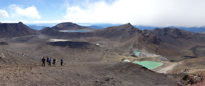
Tongariro Alpine Crossing. Photo: Tom Harris.
You will then descend on a volcanic rock scree track to the vivid Emerald Lakes, known as Nga Rotopounamu (greenstone-hued lakes). After passing Blue Lake, also known as Te Wai-whakaata-o-te-Rangihiroa (Rangihiroa's mirror), the track sidles around the northern slope of Tongariro, then descends in a lengthy and tiring zigzag track down to the road end at 760 m.
Be prepared for a long and challenging day out.
Ensure you take:
- water and food
- a waterproof jacket, hat and gloves, and warm layered clothing (no cotton)
- sunhat and sunscreen
- strong, rigid boots to prevent slips when descending the steep scree slope from Red Crater. Running shoes are not suitable.
- head torch
- mobile phone (cellphone connection is possible for much of the track)
Essential information
The Tongariro Alpine Crossing passes through volcanic hazard zones and regularly experiences geothermal activity – even when the track is open, volcanic risk is present. Steam vents, especially near Emerald Lakes, should not be approached. The steam is very hot, the ground can be unstable and severe burns are possible. Always stay on the marked track to avoid injury.
In winter (June to October), you will need special skills and preparation to complete the Tongariro Alpine Crossing. There are increased hazards from snow, ice, avalanche danger and sub-zero temperatures.
Getting there
From Labour weekend in October to 30 April, parking restrictions (4 hr maximum) are in place at the road-ends – you'll need to either book a shuttle or arrange for someone to drop you off and pick you up.
Use these links to Google Maps to find your way to the start at Mangatepopo, and the end at Ketetahi.
Helpful resources
he NZ Mountain Safety Council encourages people to continue gaining the skills and knowledge required for a safe trip. The council has lots of free resources and information you can use. These can be accessed via www.mountainsafety.org.nz.
The council recommend trying these online learning tools:
Additionally, check out the range of helpful videos available from the NZ Mountain Safety Council YouTube channel.
Notable weather conditions
The track is in an alpine environment with changeable weather conditions at all times of year.
Alpine conditions such as strong winds, cold temperatures and possible snow should be factored into planning. Cold temperatures (especially near the top) are still likely in the warmer months. A fine summers day has the possibility of afternoon convection causing thunderstorms.
If conditions are poor, try alternatives such as Taranaki Falls Walking Track or Tama Lakes Track
The Tongariro Alpine Crossing video
The video has been developed in partnership with Department of Conservation, MetService New Zealand. New Zealand Police, Ngāti Hikairo ki Tongariro, LandSAR, NZ Search and Rescue, TourismNZ, Tourism Industry Aotearoa, Visit Ruapehu, and Love Taupo.
This 2022 updated video version is one of eleven proposed solutions to improve safety on the Tongariro Alpine Crossing made by an independent Issue Specific Advisory Group established in 2018. Led by MSC, with the support of Ngāti Hikairo ki Tongariro and Department of Conservation (DOC), the group suggested that subsequent versions should be translated into other languages.
It also suggested replacing outdated footage and better demonstrating the length of hike, successful descent techniques and reinforcing alternative trip options.
The producers of the video acknowledge that the use of drones on all public conservation land is prohibited without the Department of Conservation's permission.
"All of our filming has been granted this access and we work hard to follow all of the guidelines and requirements associated with that. Visit doc.govt.nz for more information," says a video spokesperson.

0 comments
Leave a Comment
You must be logged in to make a comment.