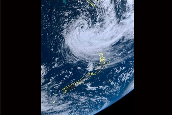
Tropical Cyclone Gabrielle is still heading for New Zealand and is likely to arrive slightly earlier than previously thought in Northland, says MetService. The cyclone is expected to arrive in Northland tonight.
"Independent of the eventual track, there is a very high risk of extreme and impactful weather over the upper North Island late Saturday then spreading south to central New Zealand by Monday," says a MetService spokesperson.
MetService have issued its highest level of warning – a Red Warning for heavy rain for Coromandel Peninsula where 300 to 400mm of rain is expected in the ranges and Tairāwhiti Gisborne north of Tolaga Bay expecting the same numbers throughout the area.
Peak intensities of 10 to 15mm per hour is expected on Sunday and 20 to 30mm per hour on Monday when the most intense rain is expected to fall.
'Central Auckland is still under a Severe Weather Watch," says MetService Head of Weather Communication, Lisa Murray.
"It hasn't been upgraded due to the uncertainty of movement of the cyclone, but it could be in the near future.
'Auckland is already sodden from recent events which could exacerbate impacts of any strong wind and rain.”
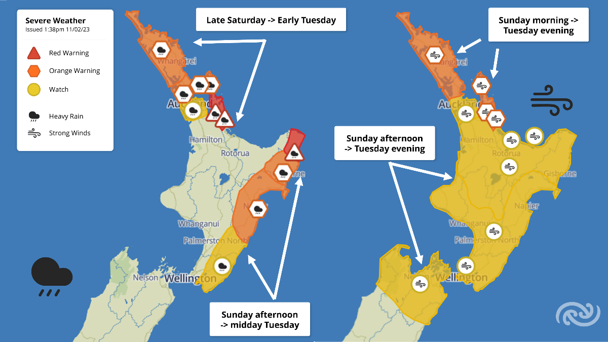
Image: MetService.
MetService Orange Warnings for Heavy Rain have been issued for Northland, north Auckland including Great Barrier Island, Coromandel Peninsula, Tairāwhiti Gisborne, and Hawke's Bay ranging between tonight - Saturday - and Tuesday.
The bulk of the rain is expected on Monday and some areas can expect to see accumulations through this event of 250 plus millimetres of rain.
Orange Wind Warnings have been issued for the Northland, Coromandel Peninsula and Auckland north of Whangaparaoa and including Great Barrier Island, where severe gales with gusts of 120 to 130 km per hour are possible.
'Strong wind gusts could damage trees, powerlines and unsecured structures. These already sodden grounds from recent floods, increases the likelihood of trees being uprooted from that heavy rain and strong winds which adds to the risk of power outages,” says Lisa.
'Heavy rain will likely cause surface flooding and landslips, as well as hazardous road conditions and road washouts. Heavy rain will also cause streams and rivers to rise rapidly.
'When there is a deep low (cyclone) just off the coast of New Zealand we see a rise in ocean level. This along with long with 5-7 metre large waves and onshore wind, may enhance coastal inundation and this effect is worse at high tide,” says Lisa.
MetService advises that the warning period could be extended in future updates, which will be highly dependent on the track of Cyclone Gabrielle. Additional areas may be upgraded to a Red Warning in consultation with Regional Councils and Emergency Management groups.
'During the severe weather from Sunday to Tuesday - depending where in the North Island and top of South Island you are situated, people should hunker down till the severe weather passes, if at all possible.”
Tropical Cyclone Gabrielle is expected to change from a tropical cyclone to a to a sub-tropical low on Sunday.
'This does not mean it weakens, in fact it spreads the strong wind and heavy rain across a wider area," says Lisa.
At this point MetService will refer to weather system Cyclone Gabrielle so there is no confusion.
This is an unfolding event and forecasts will be updated so it is important to stay in the know.
Now is a good time to download the MetService App which includes all safety critical weather information. Details can also be found at MetService.com (http://bit.ly/AllWarnings) and @MetService Facebook and Twitter.
Understanding our Severe Weather Watches and Warnings
Outlooks are about looking ahead:
- To provide advanced information on possible future Watches and/or Warning
- Issued routinely once or twice a day
- Recommendation: Plan
Watches are about being alert:
- When severe weather is possible, but not sufficiently imminent or certain for a warning to be issued
- Typically issued 1 - 3 days in advance of potential severe weather.
- During a Watch: Stay alert
Orange Warnings are about taking action:
- When severe weather is imminent or is occurring
- Typically issued 1 - 3 days in advance of potential severe weather
- In the event of an Orange Warning: Take action
Red Warnings are about taking immediate action:
- When extremely severe weather is imminent or is occurring
- Issued when an event is expected to be among the worst that we get – it will have significant impact and it is possible that a lot of people will be affected
- In the event of a Red Warning: Act now!

0 comments
Leave a Comment
You must be logged in to make a comment.